


The Wine Country wildfires destroyed Coffey Park, a subdivision within the urban boundaries of the Bay Area's fifth largest city, and outside of the state's severe fire hazard zones. But the cause wasn't a mystery to wildland fire scientists.
The Wine Country wildfires began on Sunday night, Oct. 8. One of its first major casualties of the Tubbs Fire was Coffey Park, "a compact subdivision of modest single-family homes built decades ago," reported Robert Digitale for The (Santa Rosa) Press Democrat on Oct. 9. The Associated Press called the neighborhood "Ground Zero for California fire devastation" on Oct. 14.
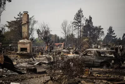
Watch a video taken from the SMART train as it goes through Coffey Park. Note the presence of trees, particularly the ones with their foliage intact, and the absence of structures in the conflagration.
The subdivision's location, within the northern boundaries of Santa Rosa, the county seat of Sonoma County, is outside the fire hazard severity zones mapped by the California Department of Forestry and Fire Protection (CAL FIRE), which made it an odd candidate for such destruction, although it is within the wildland-urban interface as drawn by at least one firm.
"The fire hazard zone shown on city and state maps was to the north and east, on the other side of the 101 Freeway," report Doug Smith and Nina Agrawal for the Los Angeles Times on Oct. 15.
“We live in a subdivision in the middle of freaking Santa Rosa,” said Anna Brooner, whose house still stands on the side of Randon Way that didn’t burn, facing a scene of rubble and ash oddly punctuated by street trees that still have leaves and a plastic recycling bin that didn’t melt.
“I could see living on the outskirts of the mountains, you always have the potential of fire,” Brooner said. “But you would never expect it in a subdivision of this size.”
Those trees help wildland fire scientists understand what made Coffey Park vulnerable to the wild fire. The subdivision was the victim of an urban fire, caused by a wildfire.
They view it as a rare, but predictable, event that has exposed flaws in the way fire risk is measured and mitigated in California. Because it was outside the officially mapped “very severe” hazard zone, more than five miles to the east, Coffey Park was exempt from regulations designed to make buildings fire resistant in high-risk areas.
Though a forensic examination will be required to understand exactly what happened at Coffey Park, the unburned trees still standing in the neighborhood tell wildland fire experts that the cause was not a giant front of flames sweeping out of the nearby hills and fields.
Most likely, the fire was touched off by embers blown from a distance. Firebrands capable of igniting a house can travel more than a mile.
Fire experts surmise that most of the damage was caused by fire spreading from house to house, leaving some parkway trees and things like trash cans oddly unscathed
FULL STORY: Despite clear risks, Santa Rosa neighborhood that burned down was exempt from state fire regulations


Wine Country Wildfires Put Spotlight on Transmission Lines
No cause has yet been attributed to California's deadliest wildfires, but the connections to fallen power lines and exploding transformers, maintained by PG&E, have been exposed in a series of reports by the Bay Area News Group.
Complying With New State Laws on ADUs No Easy Matter
Santa Rosa is struggling to complying with two laws passed last year to encourage construction of inlaw units to increase affordable housing. Council members are concerned that loosened restrictions would degrade neighborhood character.

New Commuter Train Comes Through for Fire-Ravaged Santa Rosa
Sonoma-Marin Rail Transit (SMART) has been operating almost continuously at full schedule, collecting no fares since the epic wildfires began in Sonoma County on Oct. 8. Two stations in the fire-zone are shut down due to lack of access.

Alabama: Trump Terminates Settlements for Black Communities Harmed By Raw Sewage
Trump deemed the landmark civil rights agreement “illegal DEI and environmental justice policy.”

Study: Maui’s Plan to Convert Vacation Rentals to Long-Term Housing Could Cause Nearly $1 Billion Economic Loss
The plan would reduce visitor accommodation by 25% resulting in 1,900 jobs lost.

Planetizen Federal Action Tracker
A weekly monitor of how Trump’s orders and actions are impacting planners and planning in America.

Waymo Gets Permission to Map SF’s Market Street
If allowed to operate on the traffic-restricted street, Waymo’s autonomous taxis would have a leg up over ride-hailing competitors — and counter the city’s efforts to grow bike and pedestrian on the thoroughfare.

Parklet Symposium Highlights the Success of Shared Spaces
Parklets got a boost during the Covid-19 pandemic, when the concept was translated to outdoor dining programs that offered restaurants a lifeline during the shutdown.

Federal Homelessness Agency Places Entire Staff on Leave
The U.S. Interagency Council on Homelessness is the only federal agency dedicated to preventing and ending homelessness.
Urban Design for Planners 1: Software Tools
This six-course series explores essential urban design concepts using open source software and equips planners with the tools they need to participate fully in the urban design process.
Planning for Universal Design
Learn the tools for implementing Universal Design in planning regulations.
Caltrans
Smith Gee Studio
Institute for Housing and Urban Development Studies (IHS)
City of Grandview
Harvard GSD Executive Education
Toledo-Lucas County Plan Commissions
Salt Lake City
NYU Wagner Graduate School of Public Service