


Large, adaptive-reuse projects are all the rage in urban planning today, but absent a fundamentally new approach—with affordability at the center of the process—they are likely to become engines of what's been termed "environmental gentrification."
Large, adaptive-reuse, "sustainable development" projects are all the rage these days in urban planning circles. These are projects where large pieces of abandoned or underutilized infrastructure are repurposed as centerpieces of major urban redevelopment initiatives that are couched in the rhetoric of sustainable development.
They bring positive environmental amenities to an area, including added green space, increased walkability and bicycle-friendliness, and more local shopping and retail services.
These projects are often led by local governments or their affiliate agencies and tend to involve substantial public and/or philanthropic subsidy. Examples range from New York’s High Line, to Washington, DC's 11th Street Bridge project, to Chicago's 606 Trail.
Over the last twelve years, I have studied and closely monitored one such project, the Atlanta BeltLine, and drawn some lessons from the project, particularly for cities or regions where, overall, the housing market is strong. (These lessons do not apply directly to large-scale projects in cities with declining populations or “weak market” cities. In such cities, home values and rents are likely to be stagnant or declining, and large-scale redevelopment projects that improve the desirability of declining neighborhoods are more likely to be handled without large-scale affordability problems. This is not to say that gentrification or displacement cannot occur in pockets of weak-market cities, but the scale and speed of such change is likely to be more limited.)
I have come to the conclusion that, absent a fundamentally new approach to redevelopment planning that places housing affordability at the center of the process, large-scale sustainable development projects are likely to become engines of what has been termed “environmental gentrification.”
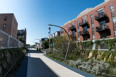
The Atlanta BeltLine will ultimately connect 45 Atlanta neighborhoods via a 22-mile loop of trails, parks, and eventually a planned streetcar, all of which will follow abandoned railroad tracks that encircle Atlanta. According to Atlanta BeltLine, Inc., the quasi-governmental agency that is building and administering the BeltLine, as of 2016 the project consists of “four open trails; two trails under construction; seven parks; intensive planning for modern streetcar expansion; more than $3 billion in private economic redevelopment; hundreds of affordable workforce homes; free fitness classes; a linear arboretum; an urban farm; and the largest temporary public art exhibition in the South.
The BeltLine is being financed by a mix of public sector financing and corporate and foundation philanthropy, at the heart of which lies tax increment financing (TIF). As the BeltLine’s principal funding mechanism, the TIF redirects increases in property tax revenues that arise after its establishment to project-related expenses rather than to the regular general revenue budgets of the city, county, or school district. The duration of the TIF in this case is 25 years, which spans from 2005 when it was adopted to 2030 when the project is expected to be fully completed.
Projects like the BeltLine have the power to transform communities so rapidly and dramatically that they call for a new approach to planning and implementation that I call “Affordability First.”
FULL STORY: Sustainable for Whom? Large-Scale Sustainable Urban Development Projects and “Environmental Gentrification”

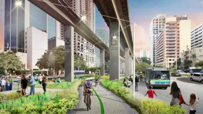
Miami’s Underline and the Threat of Gentrification
The new linear park will use land under the city’s elevated rail tracks. Worries, however, are emerging about the effects the project will have on surrounding communities, particularly related to affordable housing.
Atlanta BeltLine Raises the Specter of 'Environmental Gentrification'
Large-scale adaptive reuse projects like the BeltLine in Atlanta receive praise in many circles. But they can also release a flurry of speculation, severely threatening affordability.

Louisville Launches ‘Anti-Displacement Tool’
After a years-long, tenant-led effort, Louisville will use a new tool to analyze whether a proposed housing development can meet a neighborhood’s housing needs and income levels. If it doesn’t, the city won’t subsidize it.

Study: Maui’s Plan to Convert Vacation Rentals to Long-Term Housing Could Cause Nearly $1 Billion Economic Loss
The plan would reduce visitor accommodation by 25,% resulting in 1,900 jobs lost.

Alabama: Trump Terminates Settlements for Black Communities Harmed By Raw Sewage
Trump deemed the landmark civil rights agreement “illegal DEI and environmental justice policy.”

North Texas Transit Leaders Tout Benefits of TOD for Growing Region
At a summit focused on transit-oriented development, policymakers discussed how North Texas’ expanded light rail system can serve as a tool for economic growth.

Comment: EPA Cuts will Send Atlanta Back to Eye-burning Ozone, Lung-damaging Smog, and Raw Sewage in the Chattahoochee River
A veteran political journalist takes stock of the hard-earned ground Georgia stands to lose with slashed environmental protection.

How Community Science Connects People, Parks, and Biodiversity
Community science engages people of all backgrounds in documenting local biodiversity, strengthening connections to nature, and contributing to global efforts like the City Nature Challenge to build a more inclusive and resilient future.

Alabama: Trump Terminates Settlements for Black Communities Harmed By Raw Sewage
Trump deemed the landmark civil rights agreement “illegal DEI and environmental justice policy.”
Urban Design for Planners 1: Software Tools
This six-course series explores essential urban design concepts using open source software and equips planners with the tools they need to participate fully in the urban design process.
Planning for Universal Design
Learn the tools for implementing Universal Design in planning regulations.
City of Santa Clarita
Ascent Environmental
Institute for Housing and Urban Development Studies (IHS)
City of Grandview
Harvard GSD Executive Education
Toledo-Lucas County Plan Commissions
Salt Lake City
NYU Wagner Graduate School of Public Service