


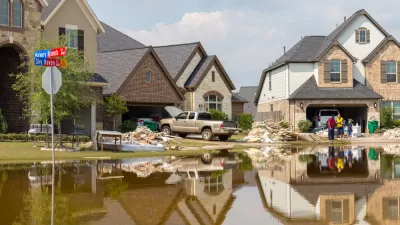
Houston received over 50 inches of rain from Hurricane Harvey in five days. While no city could survive that drenching unscathed, Houston was not prepared to handle the floods due to decades of neglect of stormwater management planning.
"[P]eople care about flooding, because it’s dramatic and catastrophic," writes Ian Bogost, a contributing editor at The Atlantic in an in depth article on the flooding that Houston is experiencing since Aug. 25 due to Hurricane Harvey. "They don’t care about stormwater management, which is where the real issue lies."
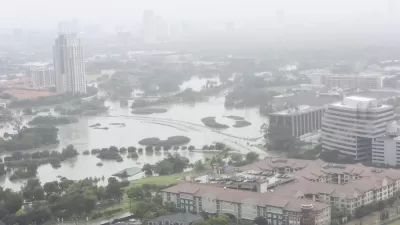
Houston poses both a typical and an unusual situation for stormwater management. The city is enormous, stretching out over 600 square miles. It’s an epitome of the urban sprawl characterized by American exurbanism, where available land made development easy at the edges.
Unlike New Orleans, Houston is well above sea level, so flooding risk from storm surge inundation is low. Instead, it’s rainfall that poses the biggest threat.
"Houston is the most flood-prone city in the United States," said Rice University environmental engineering professor Phil Bedient, in an article by the Associated Press on the city's "obsolete drainage grid." "No one is even a close second — not even New Orleans, because at least they have pumps there."
Bogost offers two different approaches to stormwater management. Once focuses on decreasing impervious surfaces [also see Michael Lewyn's blog post on Aug. 30].
Many planners contend that impervious surface itself is the problem. The more of it there is, the less absorption takes place and the more runoff has to be managed. Reducing development, then, is one of the best ways to manage urban flooding. The problem is, urban development hasn’t slowed in the last half-century.
But Thomas Debo, an emeritus professor of city planning at Georgia Tech who also wrote a popular textbook on stormwater management, takes issue with pavement reduction as a viable cure for urban flooding.
“We focus too much on impervious surface and not enough on the conveyance of water,” he tells me. Even when reduced in quantity, the water still ends up in in pipes and concrete channels, speeding fast toward larger channels. “It’s like taking an aspirin to cure an ailment,” he scoffs. Houston’s flooding demonstrates the impact.
Water conveyance was built into Houston drainage plan. It supplements the "slow-moving rivers, called bayous, (that) provide natural drainage for the area," writes Bogost.
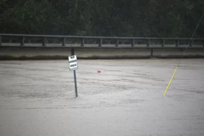
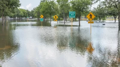
To account for the certainty of flooding, Houston has built drainage channels, sewers, outfalls, on- and off-road ditches, and detention ponds to hold or move water away from local areas. When they fill, the roadways provide overrun. The dramatic images from Houston that show wide, interstate freeways transformed into rivers look like the cause of the disaster, but they are also its solution, if not an ideal one.
And this approach vindicates Houston Mayor Sylvester Turner's decision to not call for a mandatory evacuation, which many have questioned.
This is also why evacuating Houston, a metropolitan area of 6.5 million people, would have been a terrible idea. This is a city run by cars, and sending its residents to sit in gridlock on the thoroughfares and freeways designed to become rivers during flooding would have doomed them to death by water.
Vox's science reporter, Brian Resnick, also investigated Houston's flood-prone geography, and interviewed Rice's Phil Bedient as well. He offered several reasons why the flooding was so severe, among them, urban sprawl contributing to a lack of impervious spaces due to concreting the landscape. Resnick also cited another reason to vindicate Mayor Turner's non-evacuation decision.
In 2005 Houston issued an evacuation order for 2.5 million people for Hurricane Rita. It was chaotic: More than 100 people died while evacuating. People were stuck on the roadways for days.
As of Aug. 30, the death toll from Hurricane Harvey is 30 people. Harvey has made a second landfall and is wreaking havoc in Port Arthur and Beaumont, Texas, as it did Houston.

Houston's Latest Stormwater Project: 'Massive, Underground Tunnels'
The most recent post-Harvey proposal would mean the city could endure enormous rain events, but so far it's not clear who would pay for it.
A Year After Harvey, Homes Still Going Up on Houston Flood Plain
Despite the devastation wrought by Hurricane Harvey, builders and buyers alike are sustaining a market for new construction on land likely to get flooded again.
Houston Seriously Tightens Rules on Floodplain Construction
It was the city's "first major regulatory response" to Hurricane Harvey.

Alabama: Trump Terminates Settlements for Black Communities Harmed By Raw Sewage
Trump deemed the landmark civil rights agreement “illegal DEI and environmental justice policy.”

Study: Maui’s Plan to Convert Vacation Rentals to Long-Term Housing Could Cause Nearly $1 Billion Economic Loss
The plan would reduce visitor accommodation by 25% resulting in 1,900 jobs lost.

Planetizen Federal Action Tracker
A weekly monitor of how Trump’s orders and actions are impacting planners and planning in America.

Wind Energy on the Rise Despite Federal Policy Reversal
The Trump administration is revoking federal support for renewable energy, but demand for new projects continues unabated.

Passengers Flock to Caltrain After Electrification
The new electric trains are running faster and more reliably, leading to strong ridership growth on the Bay Area rail system.

Texas Churches Rally Behind ‘Yes in God’s Back Yard’ Legislation
Religious leaders want the state to reduce zoning regulations to streamline leasing church-owned land to housing developers.
Urban Design for Planners 1: Software Tools
This six-course series explores essential urban design concepts using open source software and equips planners with the tools they need to participate fully in the urban design process.
Planning for Universal Design
Learn the tools for implementing Universal Design in planning regulations.
Caltrans
Smith Gee Studio
Institute for Housing and Urban Development Studies (IHS)
City of Grandview
Harvard GSD Executive Education
Toledo-Lucas County Plan Commissions
Salt Lake City
NYU Wagner Graduate School of Public Service