


Wildfires tend to start at the Wildland-Urban Interface: those border zones between cities and the open land surrounding them. Keeping the lid on sprawl, it can be argued, would tame the inferno.
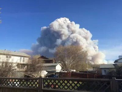
As another summer of wildfires blazes on, it's hard not to notice the types of neighborhoods they regularly threaten. Adam Rogers writes, "The key to how we think about fire's severity [...] is not the number of fires, or even their magnitude, but where they are—and what's near them."
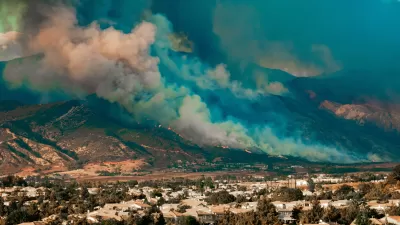
In fire-prone states like California, Texas, and Colorado, suburban sprawl often occupies the Wildland-Urban Interface (WUI) where wildfires often start. "Humans set most wildfires—95 percent of them, according to CalFire. That's a real problem when, as of 2004 in the continental US, the WUI was almost 278,000 square miles and contained 44.8 million housing units."
In a sense, the urban housing crisis exacerbates our risk from fire, and those affected are those priced out. "At a time when cities all over the country are experiencing housing crises, unable or unwilling to build enough units to accommodate growing populations, the greatest expansion of houses is on previously unbuilt spaces at the edges of cities."
FULL STORY: The West Is on Fire. Blame the Housing Crisis

Home Insurers Are Fleeing California
Homeowners in the state are finding it increasingly difficult to secure insurance policies thanks to the growing risks of wildfire, drought, and other climate threats.
As Central Texas Population Grows, So Does Fire Risk
Sprawl in and around Austin is contributing to growing wildfire risks, and local officials worry about a lack of public awareness of the issue.
Between a Rock and a Hard Place: Housing and Fire Safety in California
A proposed development near the site of the devastating Camp Fire highlights the growing tension between building badly needed housing and protecting communities from heightened wildfire risk.

Alabama: Trump Terminates Settlements for Black Communities Harmed By Raw Sewage
Trump deemed the landmark civil rights agreement “illegal DEI and environmental justice policy.”

Planetizen Federal Action Tracker
A weekly monitor of how Trump’s orders and actions are impacting planners and planning in America.

How Atlanta Built 7,000 Housing Units in 3 Years
The city’s comprehensive, neighborhood-focused housing strategy focuses on identifying properties and land that can be repurposed for housing and encouraging development in underserved neighborhoods.

In Both Crashes and Crime, Public Transportation is Far Safer than Driving
Contrary to popular assumptions, public transportation has far lower crash and crime rates than automobile travel. For safer communities, improve and encourage transit travel.

Report: Zoning Reforms Should Complement Nashville’s Ambitious Transit Plan
Without reform, restrictive zoning codes will limit the impact of the city’s planned transit expansion and could exclude some of the residents who depend on transit the most.

Judge Orders Release of Frozen IRA, IIJA Funding
The decision is a victory for environmental groups who charged that freezing funds for critical infrastructure and disaster response programs caused “real and irreparable harm” to communities.
Urban Design for Planners 1: Software Tools
This six-course series explores essential urban design concepts using open source software and equips planners with the tools they need to participate fully in the urban design process.
Planning for Universal Design
Learn the tools for implementing Universal Design in planning regulations.
Jessamine County Fiscal Court
Caltrans
Institute for Housing and Urban Development Studies (IHS)
City of Grandview
Harvard GSD Executive Education
Toledo-Lucas County Plan Commissions
Salt Lake City
NYU Wagner Graduate School of Public Service