


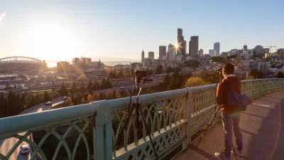
After repainting the lanes on Rainier Avenue in Seattle, the street works better for everyone. If it's that easy, why isn't the model implemented more widely?
"A 2015 safe streets redesign on Rainier Ave is working even better than expected by nearly every measure," according to an article by Tom Fucoloro.
Just by repainting the lines on the major street, the city’s Vision Zero team was able to dramatically reduce the number of dangerous collisions, nearly eliminate high-end speeding, speed up transit, and fully eliminate serious injuries and deaths. Meanwhile, delays for people driving were minimal, clocking in well below pre-construction estimates, according to a new report (PDF).
The article recounts the community-led political effort that produced the changes and also unpacks the data regarding the improvements on the street in a lot more detail.
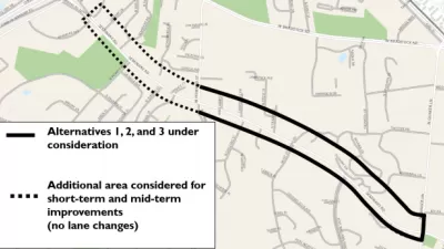
Planetizen picked up on the news about the changes on Rainier Avenue back in January 2016, when the project made news as a solution for Seattle's "most dangerous" street. Part of the reason that the project is back in the news is the Seattle Department of Transportation is starting a public outreach process for a proposed extension of safety project "from the current project boundary south of Hillman City all the way to Rainier Beach."
Hat tip to Streetsblog USA's Twitter feed for the link to the story. Streetsblog USA editor Angie Schmitt added additional commentary on the news about Rainier Avenue's improvements on her Twitter feed, as shown below.
We know how to drastically reduce traffic deaths. We just don't do it https://t.co/ItSritpCwf
— Angie Schmitt (@schmangee) February 24, 2017
FULL STORY: Rainier Ave safety project worked even better than planned, city will extend it south

A Thorough, Mixed Review for a New Protected Bike Lane in Seattle
So many highly anticipated bike facilities finally deliver only to fall short of real game changing status. Seattle provides the latest example of the phenomenon in the wild.
Fixing Seattle's Most Dangerous Road
In-depth coverage of the improvement efforts underway on Seattle's Rainier Avenue.
When it Comes to Road Diets, Evidence Doesn't Matter
Drivers are a powerful enough lobby to overcome all evidence of the need to redesign streets for safety. Examples from Maryland and Virginia provide the latest case studies in Vision Zero futility.

Alabama: Trump Terminates Settlements for Black Communities Harmed By Raw Sewage
Trump deemed the landmark civil rights agreement “illegal DEI and environmental justice policy.”

Study: Maui’s Plan to Convert Vacation Rentals to Long-Term Housing Could Cause Nearly $1 Billion Economic Loss
The plan would reduce visitor accommodation by 25% resulting in 1,900 jobs lost.

Planetizen Federal Action Tracker
A weekly monitor of how Trump’s orders and actions are impacting planners and planning in America.

Waymo Gets Permission to Map SF’s Market Street
If allowed to operate on the traffic-restricted street, Waymo’s autonomous taxis would have a leg up over ride-hailing competitors — and counter the city’s efforts to grow bike and pedestrian on the thoroughfare.

Parklet Symposium Highlights the Success of Shared Spaces
Parklets got a boost during the Covid-19 pandemic, when the concept was translated to outdoor dining programs that offered restaurants a lifeline during the shutdown.

Federal Homelessness Agency Places Entire Staff on Leave
The U.S. Interagency Council on Homelessness is the only federal agency dedicated to preventing and ending homelessness.
Urban Design for Planners 1: Software Tools
This six-course series explores essential urban design concepts using open source software and equips planners with the tools they need to participate fully in the urban design process.
Planning for Universal Design
Learn the tools for implementing Universal Design in planning regulations.
Caltrans
Smith Gee Studio
Institute for Housing and Urban Development Studies (IHS)
City of Grandview
Harvard GSD Executive Education
Toledo-Lucas County Plan Commissions
Salt Lake City
NYU Wagner Graduate School of Public Service