


Comprehensive plans can be big and unwieldy. Luckily for Washington, D.C., there are two maps that unlock of the plan's meaning.
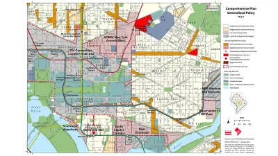
David Whitehead sifts through the 600 pages of the D.C. Comprehensive Plan and identifies the two maps that provide access to the plan's core ideas.
"DC has a giant planning document called the Comprehensive Plan. Most of it is super dense and complicated, but its goal is to lay the foundation for many city-wide decisions, in particular decisions on land use," explains Whitehead. "Partially because of its size and obscurity, many people just focus on two maps that exist as part of the Comp Plan: the Future Land Use Map (FLUM), and the Generalized Policy Map."
Whitehead then digs into both of the two maps, illuminating the key ideas that will help guide an understanding of these already most accessible parts of the D.C. Comprehensive Plan.
But then, there's a caveat. According to Whitehead, "[t]here's one big issue with both of these maps: they tend to preserve the status quo—more specifically, the status quo of 2006, which is when the Comp Plan was created." Luckily, Whitehead reports that the D.C. Office of Planning is "organizing an effort to amend and update the Comprehensive Plan."
FULL STORY: These two maps are the guides to your neighborhood's future. Here's what you should know about them.


D.C. Comprehensive Plan Update Needs Equity Improvements, Report Says
The new D.C. Office of Equity has produced an evaluation of proposed changes to the D.C. Comprehensive Plan.

Comprehensive Plan Update Stokes Controversy in D.C.
Complex political dynamics are mustering for a showdown over D.C.'s comprehensive plan.

Why Have ADUs Proliferated in Portland, Lagged in D.C.?
A new report by the Urban Institute examines the consequences of small differences in land use regulations.

Alabama: Trump Terminates Settlements for Black Communities Harmed By Raw Sewage
Trump deemed the landmark civil rights agreement “illegal DEI and environmental justice policy.”

Study: Maui’s Plan to Convert Vacation Rentals to Long-Term Housing Could Cause Nearly $1 Billion Economic Loss
The plan would reduce visitor accommodation by 25% resulting in 1,900 jobs lost.

Why Should We Subsidize Public Transportation?
Many public transit agencies face financial stress due to rising costs, declining fare revenue, and declining subsidies. Transit advocates must provide a strong business case for increasing public transit funding.

Paris Bike Boom Leads to Steep Drop in Air Pollution
The French city’s air quality has improved dramatically in the past 20 years, coinciding with a growth in cycling.

Why Housing Costs More to Build in California Than in Texas
Hard costs like labor and materials combined with ‘soft’ costs such as permitting make building in the San Francisco Bay Area almost three times as costly as in Texas cities.

San Diego County Sees a Rise in Urban Coyotes
San Diego County experiences a rise in urban coyotes, as sightings become prevalent throughout its urban neighbourhoods and surrounding areas.
Urban Design for Planners 1: Software Tools
This six-course series explores essential urban design concepts using open source software and equips planners with the tools they need to participate fully in the urban design process.
Planning for Universal Design
Learn the tools for implementing Universal Design in planning regulations.
Smith Gee Studio
Alamo Area Metropolitan Planning Organization
City of Santa Clarita
Institute for Housing and Urban Development Studies (IHS)
City of Grandview
Harvard GSD Executive Education
Toledo-Lucas County Plan Commissions
Salt Lake City
NYU Wagner Graduate School of Public Service