


A case study in New York's response to the Hurricane Sandy flooding in the neighborhoods of Coney Island and Gravesend.
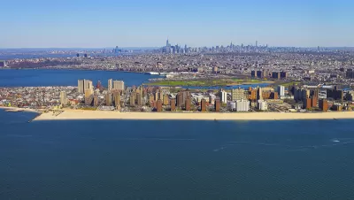
The New York Economic Development Corporation recently announced its release of the Coney Island Creek Resiliency Study, described as "a critical component to resiliency planning for the communities around Coney Island Creek."
"During Hurricane Sandy, Coney Island Creek was the main source of inundation for much of the Gravesend and Coney Island neighborhoods. Low edges and topography contributed to 'backdoor' flooding that caused enormous damage," according to the announcement.
The "study investigated several strategies to mitigate upland flooding, improve waterfront open space, strengthen neighborhood connections, enhance infrastructure, and provide opportunity for economic development around the Creek." A key finding of the study was the tie continued plans to study and plan for flood risk along the creek into broader regional efforts by the city and states of New York, along with the United States Army Corps of Engineers.
FULL STORY: Coney Island Creek Resiliency Study

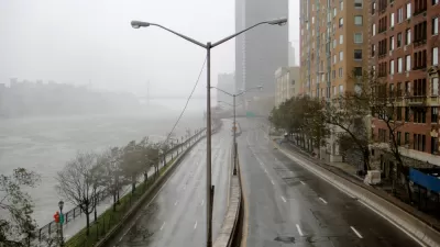
Saving Lower Manhattan
A debate over how to protect the East River waterfront from Sandy-level flooding and storm damage has delayed the project as community activists decry the city's last-minute change of plans.

In Battery Park City, Public Infrastructure Meets Climate Resilience
A massive project underway in Lower Manhattan seeks to protect the shoreline from future flooding and mitigate the effects of climate change and rising sea levels.

Net Zero Development Coming to New York City
The project, which relies largely on geothermal energy to minimize its carbon footprint, will bring affordable housing and boost storm resilience to an area devastated by Hurricane Sandy.

Alabama: Trump Terminates Settlements for Black Communities Harmed By Raw Sewage
Trump deemed the landmark civil rights agreement “illegal DEI and environmental justice policy.”

Study: Maui’s Plan to Convert Vacation Rentals to Long-Term Housing Could Cause Nearly $1 Billion Economic Loss
The plan would reduce visitor accommodation by 25% resulting in 1,900 jobs lost.

Planetizen Federal Action Tracker
A weekly monitor of how Trump’s orders and actions are impacting planners and planning in America.

Waymo Gets Permission to Map SF’s Market Street
If allowed to operate on the traffic-restricted street, Waymo’s autonomous taxis would have a leg up over ride-hailing competitors — and counter the city’s efforts to grow bike and pedestrian on the thoroughfare.

Parklet Symposium Highlights the Success of Shared Spaces
Parklets got a boost during the Covid-19 pandemic, when the concept was translated to outdoor dining programs that offered restaurants a lifeline during the shutdown.

Federal Homelessness Agency Places Entire Staff on Leave
The U.S. Interagency Council on Homelessness is the only federal agency dedicated to preventing and ending homelessness.
Urban Design for Planners 1: Software Tools
This six-course series explores essential urban design concepts using open source software and equips planners with the tools they need to participate fully in the urban design process.
Planning for Universal Design
Learn the tools for implementing Universal Design in planning regulations.
Caltrans
Smith Gee Studio
Institute for Housing and Urban Development Studies (IHS)
City of Grandview
Harvard GSD Executive Education
Toledo-Lucas County Plan Commissions
Salt Lake City
NYU Wagner Graduate School of Public Service