


Georgetown's grid of small blocks is starkly different from the L'Enfant-designed city that surrounds it.
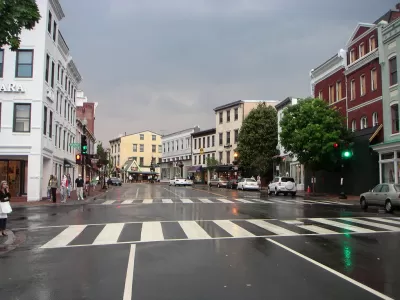
The origins of Washington, D.C.'s Georgetown neighborhood can be traced back to a Scottish man named Ninian Beall, who had the original grant for the land where the neighborhood would develop from a tobacco inspection station to a busy commercial port. Writing in Greater Greater Washington, Topher Mathews traces the history of the neighborhood to its eventual development into a grid comprised of small blocks.
The layout of Georgetown was a typical modest colonial town. The 80 lots were separated by only two streets and two narrow lanes. In the 1780s, several additions were annexed to the town.
...
While the physical structures hadn't filled in the street grid by the 1790s, Pierre L'Enfant nonetheless concluded that Georgetown was too developed with its own town plan to be incorporated into his Baroque plan for the city of Washington.
This design independence has survived to the present day as Georgetown lacks the circles and radials of the rest of downtown Washington.
Matthews notes that while Georgetown's original grid layout survived, many of its street names did not. As Washington, D.C. grew around it and eventually merged with it in 1872, many of the original street names were changed to match the D.C. street system.
FULL STORY: The story behind Georgetown's street grid


Is Washington D.C. Preserving Buildings or Hoarding Them?
A piecemeal, reactive approach to historic preservation in the capital may burden the future with too many buildings of "middling merit."
Georgetown-Rosslyn Gondola Proposal Gets a Funded Study
The idea of a gondola crossing the Potomac might still seem a little pie in the sky, but it has legs.
A New Future Proposed for Georgetown
After announcing its Georgetown 2028 Plan last year, the Georgetown Business Improvement District is continuing its ambitious efforts to bring new facilities and amenities online in Georgetown.

Alabama: Trump Terminates Settlements for Black Communities Harmed By Raw Sewage
Trump deemed the landmark civil rights agreement “illegal DEI and environmental justice policy.”

Study: Maui’s Plan to Convert Vacation Rentals to Long-Term Housing Could Cause Nearly $1 Billion Economic Loss
The plan would reduce visitor accommodation by 25% resulting in 1,900 jobs lost.

Planetizen Federal Action Tracker
A weekly monitor of how Trump’s orders and actions are impacting planners and planning in America.

Waymo Gets Permission to Map SF’s Market Street
If allowed to operate on the traffic-restricted street, Waymo’s autonomous taxis would have a leg up over ride-hailing competitors — and counter the city’s efforts to grow bike and pedestrian on the thoroughfare.

Parklet Symposium Highlights the Success of Shared Spaces
Parklets got a boost during the Covid-19 pandemic, when the concept was translated to outdoor dining programs that offered restaurants a lifeline during the shutdown.

Federal Homelessness Agency Places Entire Staff on Leave
The U.S. Interagency Council on Homelessness is the only federal agency dedicated to preventing and ending homelessness.
Urban Design for Planners 1: Software Tools
This six-course series explores essential urban design concepts using open source software and equips planners with the tools they need to participate fully in the urban design process.
Planning for Universal Design
Learn the tools for implementing Universal Design in planning regulations.
Caltrans
Smith Gee Studio
Institute for Housing and Urban Development Studies (IHS)
City of Grandview
Harvard GSD Executive Education
Toledo-Lucas County Plan Commissions
Salt Lake City
NYU Wagner Graduate School of Public Service