


NextCity surveys a variety of new data-collecting technologies meant to clarify the impacts of bike and pedestrian infrastructure projects.
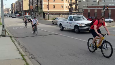
Bike advocates rely on the Census Bureau's American Community Survey to measure demographics and trends in urban cycling. But local conclusions drawn from that big-picture data can be misleading, Next City reports, and more precise strategies are in the works—including "bike-counter totems, GPS-enabled smartphone apps and cameras that use machine learning."
One piece of hardware, Numina, can count the users of a piece of infrastructure and discern patterns in their behavior. It uses a camera programmed to recognize and count moving parts like cyclists or pedestrians.
Others, like Strava and MapMyRide, can track bike routes via GPS and smartphone apps, as well as users' demographic data.
Each approach has its advantages and shortcomings, but advocates hope that together they can contribute to a more robust understanding of the impacts of complete streets infrastructure.
FULL STORY: More Accurate Bicycle Counter Could Give Complete Streets Advocates a Boost


Rochester to Update Bicycle Master Plan with More Multimodal Infrastructure
The new active transportation plan will amend the existing bicycle master plan to include additional safety improvements for pedestrians and other multimodal road users.

New Bikeways Coming to Atlanta This Year
Several new bike projects in the Atlanta area are slated to begin construction this year.
Bay Area Leads the Nation in Reducing Solo Commuters
According to the Census Bureau's American Community Survey on commuting to work, one subregion in the Bay Area can claim accolades for having achieved the largest drop in solo-commuting from 2006, scoring the third lowest drive-alone rate in 2013.

What ‘The Brutalist’ Teaches Us About Modern Cities
How architecture and urban landscapes reflect the trauma and dysfunction of the post-war experience.

‘Complete Streets’ Webpage Deleted in Federal Purge
Basic resources and information on building bike lanes and sidewalks, formerly housed on the government’s Complete Streets website, are now gone.

Downtown Los Angeles on the Rise: A Promising 2025
Fueled by new developments, cultural investments, and a growing dining scene, downtown Los Angeles is poised for significant growth in 2025, despite challenges from recent wildfires and economic uncertainties.

San Francisco Slow Streets Bucks Citywide Trend, Reducing Injuries by 61 Percent
Low-cost interventions aimed at slowing traffic are making a major impact on road safety.

How Single-Family Conversions Benefit Both Homeowners and Cities
Converting single-family homes to triplexes can ease the housing crisis and offer affordable, flexible options for more households. Why is it largely illegal?

Report: Transportation Equity Requires More Than Electrification
Lower-income households often lack the resources to buy electric cars, signaling a need for a more holistic approach to improving mobility and lowering transportation costs.
Urban Design for Planners 1: Software Tools
This six-course series explores essential urban design concepts using open source software and equips planners with the tools they need to participate fully in the urban design process.
Planning for Universal Design
Learn the tools for implementing Universal Design in planning regulations.
Economic & Planning Systems, Inc.
UCLA Lewis Center for Regional Policy Studies
Mpact (formerly Rail~Volution)
Chaddick Institute at DePaul University
City of Piedmont, CA
Great Falls Development Authority, Inc.
HUDs Office of Policy Development and Research