


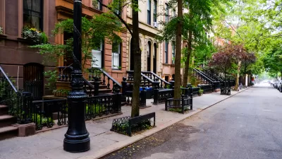
Inside access to a huge volunteer effort underway in New York City to account for the condition of an estimated 600,000 street trees—where every single one of the city's trees counts.
"For the first time ever, the NYC Department of Parks and Recreation is working with thousands of volunteers to measure and map every single street tree on every single block in every single neighborhood in all five boroughs of the city," reports Philip Silva.
The article provides an in-depth look at the mechanics of the effort, dubbed TreesCount! 2015, which has ambitiously deployed 5,000 volunteers (so far) for "old fashioned site-surveying techniques." That means, according to SIlva: "No GPS. No Google Street View. No satellite imagery. Just a $90 measuring wheel, a plastic tape measure, and a meticulously designed data logging website filled to the brim with sophisticated geometry, cartography, and code."
The effort has already mapped 100,000 of the estimated 600,000 trees that call New York City home since it launched in May.
Also explained by Silva is the larger purpose of the census, namely: "NYC Parks, the department that oversees street trees in the Big Apple, wants to know what kinds of challenges each tree is facing and how much effort neighborhood volunteers are putting into keeping trees alive."
FULL STORY: Mapping the Forest for the Trees: A Census Grows in the Five Boroughs


Tree Folio NYC Aims to Monitor Urban Forest in Real Time
A new tool could help the city reach its goal of planting up to 250,000 new trees by 2035.
Looking to Add More Trees? Mind the 'Sidewalk Gray Zone'
A case study provided by the MillionTreesNYC program offers insight into complicated territorial boundaries that can challenge urban greening projects.

Invasive Beetles Put Oregon Forests at Risk
Two recently discovered borer beetles could lead to a significant loss of tree canopy.

Alabama: Trump Terminates Settlements for Black Communities Harmed By Raw Sewage
Trump deemed the landmark civil rights agreement “illegal DEI and environmental justice policy.”

Planetizen Federal Action Tracker
A weekly monitor of how Trump’s orders and actions are impacting planners and planning in America.

How Atlanta Built 7,000 Housing Units in 3 Years
The city’s comprehensive, neighborhood-focused housing strategy focuses on identifying properties and land that can be repurposed for housing and encouraging development in underserved neighborhoods.

In Both Crashes and Crime, Public Transportation is Far Safer than Driving
Contrary to popular assumptions, public transportation has far lower crash and crime rates than automobile travel. For safer communities, improve and encourage transit travel.

Report: Zoning Reforms Should Complement Nashville’s Ambitious Transit Plan
Without reform, restrictive zoning codes will limit the impact of the city’s planned transit expansion and could exclude some of the residents who depend on transit the most.

Judge Orders Release of Frozen IRA, IIJA Funding
The decision is a victory for environmental groups who charged that freezing funds for critical infrastructure and disaster response programs caused “real and irreparable harm” to communities.
Urban Design for Planners 1: Software Tools
This six-course series explores essential urban design concepts using open source software and equips planners with the tools they need to participate fully in the urban design process.
Planning for Universal Design
Learn the tools for implementing Universal Design in planning regulations.
Caltrans
Smith Gee Studio
Institute for Housing and Urban Development Studies (IHS)
City of Grandview
Harvard GSD Executive Education
Toledo-Lucas County Plan Commissions
Salt Lake City
NYU Wagner Graduate School of Public Service