


Many places are statistically diverse, but their inhabits can be worlds apart. A local perspective (and finer data) is needed to fully appreciate how different races and classes inhabit a neighborhood.
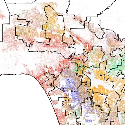
While the 98118 zip code near Seattle gained some fame in 2010 for its statistical diversity, University of Washington researchers Ryan Gabriel and Tim Thomas weren't so sure. They decided to take a closer look. Said Gabriel, "'It's a highly-diverse city in some ways, but as you kind of walk the city, you experience a real sense of separation between racial groups and class levels as well.'"
There can be cultural and economic gulfs between communities only minutes apart. From the article: "In Columbia City, for example, the researchers found the west side of the tract had lots of immigrant markets and fast food restaurants. On the predominantly white side of the tract near the bay were five-star restaurants serving $60 entrees."
In that example, even a physical barrier separated white from black, rich from poor. "A steep north-south ridge that can't be crossed by foot divides the tract. More than 78 percent of black residents life on the west side of the ridge, where most homes are run down and few new homes exist [...]"
The researchers found similar results in cities across the United States. The racial dot map, a version of which appears in the article, is an invaluable tool to appreciate finer degrees of segregation. The map uses 2010 census data and includes Hawaii and Alaska.
FULL STORY: When “diverse” neighborhoods are more segregated than they appear


How Cities Can Avoid Perpetuating Segregation
Residents of big cities, known as the ‘melting pots’ of America, have fewer interactions with people outside their socioeconomic group than those in smaller communities, according to new research.

What We Really Mean When We Say Gentrification
The focus on gentrifying communities has, in many cases, eclipsed the similar problems facing more stagnant neighborhoods.
What Trump Gets Wrong About America’s Suburbs
The Trump administration’s talk about protecting the suburbs is based on misrepresentations of who really lives in suburbs and what these communities need.

Alabama: Trump Terminates Settlements for Black Communities Harmed By Raw Sewage
Trump deemed the landmark civil rights agreement “illegal DEI and environmental justice policy.”

Study: Maui’s Plan to Convert Vacation Rentals to Long-Term Housing Could Cause Nearly $1 Billion Economic Loss
The plan would reduce visitor accommodation by 25% resulting in 1,900 jobs lost.

Why Should We Subsidize Public Transportation?
Many public transit agencies face financial stress due to rising costs, declining fare revenue, and declining subsidies. Transit advocates must provide a strong business case for increasing public transit funding.

Paris Bike Boom Leads to Steep Drop in Air Pollution
The French city’s air quality has improved dramatically in the past 20 years, coinciding with a growth in cycling.

Why Housing Costs More to Build in California Than in Texas
Hard costs like labor and materials combined with ‘soft’ costs such as permitting make building in the San Francisco Bay Area almost three times as costly as in Texas cities.

San Diego County Sees a Rise in Urban Coyotes
San Diego County experiences a rise in urban coyotes, as sightings become prevalent throughout its urban neighbourhoods and surrounding areas.
Urban Design for Planners 1: Software Tools
This six-course series explores essential urban design concepts using open source software and equips planners with the tools they need to participate fully in the urban design process.
Planning for Universal Design
Learn the tools for implementing Universal Design in planning regulations.
Smith Gee Studio
Alamo Area Metropolitan Planning Organization
City of Santa Clarita
Institute for Housing and Urban Development Studies (IHS)
City of Grandview
Harvard GSD Executive Education
Toledo-Lucas County Plan Commissions
Salt Lake City
NYU Wagner Graduate School of Public Service