


Private, crowdsourced mobile phone applications addressing urban mobility collect troves of data on how cities flow. So how can municipalities tap into these databases to accurately understand the movement of their citizens?

Imagine a municipality totally in tune with the demand and behaviors of its populace. It understands how people move in the city, their preferences, and how outside factors like weather, time of day, and season, augment their movements. The city can adjust transit service frequency based on a weather forecast, implement bicycle infrastructure per actual demand as opposed to loudest voice, and prioritize repaving projects based on travel demand and stress, all with the utmost of precision and accuracy.
Although cities are beginning to utilize big data to inform operations with quantitative insight, it is difficult and expensive for municipalities to create comparable databases to private crowdsourcing applications due to bureaucracy and budget restrictions. Behind these applications lie extensive cyber infrastructure, large marketing campaigns, and investment funding that are years in the making by savvy and well-connected entrepreneurs. Municipalities simply do not have the same resources (namely, money and time) at their disposal.
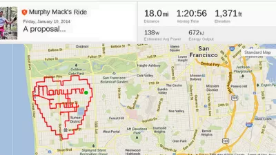
The rise in smart phone applications addressing mobility has conspicuously targeted drivers, but cyclists, pedestrians, and public transit users are also benefitting from a growing collection of mobility-enhancing apps. Applications such as Waze, Strava, and RideScout cover the full spectrum of modes available to urbanites trying to get from point A to point B. As they route people, these applications simultaneously amass huge troves of anonymized information on the flow of transportation systems within cities.
So, how do such private crowdsourcing applications share data with city municipalities? What are their terms of exchange? How do cities apply these information troves? Some cities are already forging these partnerships, but there are still steps to take before realizing a fully-optimized reality.
Waze is a popular free social mobile application that allows drivers to create and utilize live maps, real-time traffic updates and turn-by-turn navigation. With over ten million active users each day in the United States, Waze anonymizes its data, then stores the date, time of day, speed, origin and destination, routing preferences, and crowdsourced road conditions (e.g., accident reports, congestion, police traps) for all users.
According to Julie Mossler, the senior director of communications at Waze, these aggregated trips can be compiled into a large database tracking city flows, travel trends, updated traffic conditions, and congestion. So far, Rio de Janeiro Brazil (Centro de Operaciones or COR), the Florida Department of Transportation (DOT), and the city of Jakarta have entered into data sharing agreements with Waze. These cities combine their own traffic data and information with Waze, and in exchange, these municipalities receive incident data (e.g., accidents, traffic jams, weather reports) and road closure data as reported by their citizens. Because Waze generates revenues from their advertising platform, the company is free to, "make decisions around the partner program that are in the best interest of users and cities, not motivated by financial gain," said Mossler, adding "[improving] city efficiency and emergency response is in itself incredibly rewarding."
Mossler shared that Florida's DOT wanted to obtain live, pinpointed, traffic condition reports. For this partnership, Waze aggregates, "all traffic information as reported by the DOT, combine[s] it with Waze reports, and send[s] them a condensed summary." Without the aid of a fast-moving private company outside the bounds of government bureaucracy, the Florida DOT would not accomplish such a feat at this scale and speed.
While Waze reports on automobile traffic and conditions, Strava allows cyclists, runners, and athletes to track and record data and interact with other users. Strava users upload about 2.5 million activities (cycling or running) every week, from hundreds of countries. Strava allows users to track their performance metrics (e.g., routes, speed, elevation, frequency) and time of day and activity dates.
The aggregated information (like Waze, Strava anonymizes its data before distributing it) is gathered in a database, marketed toward municipalities. This program, called StravaMetro, contains GPS points, cyclists and pedestrian counts, origin-destination matrixes, and the routes chosen (and not chosen) by cyclists and runners.
According to Strava co-founder Michael Horvath, StravaMetro aims to "improve the quality of the data [municipalities] use and allows them to advocate for more money towards the cycling infrastructure or alternative transportation infrastructure." Indeed, the municipality of Brisbane, Australia, after partnering with StravaMetro, "showed that within two weeks of putting in a new bike path, they were able to move bike traffic from the previous road to the bike path and almost 95 percent of the new traffic was going along the bike path within two weeks." Providing historic counts, StravaMetro has so far partnered with Oregon DOT; Toronto, Canada; London, England; Brisbane, Australia; Orlando, Florida; Baltimore, Maryland; Evanston, Illinois; and 15 other metros around the world.
The program's pioneer, Oregon DOT, paid $20,000 for a yearlong license to receive StravaMetro data, ranging from January 2013 until December 2013, tracking 35,000 cyclists and over 400,000 trips. According to telephone conversation with Margi Bradway, former ODOT Active Transportation Project Manager and current Portland Bureau of Transportation Active Transportation Division Manager, ODOT is assessing seasonal and time of day discrepancies and distance at the macro level, as well as cyclist behavioral patterns, level of bike stress, and verification of infrastructure use at the micro or street level.
However, unlike Waze, Strava mostly targets hardcore athletes rather than the general commuter cyclist population, skewing its population representation. To assess the validity of the data, ODOT compared the Strava database to its existing ridership counts and found that "[Strava users] ride like the general public." With Strava's data, Oregon DOT is working to create a multimodal travel demand forecasting model, including transit, vehicles, freight, bicycling, and pedestrians.
Come December, ODOT will publish a white paper detailing StravaMetro's utility and shortcomings. With that report, ODOT can hopefully, "push the private market— whether it's Strava or another innovator— to design an app with a broader scope, or include kids, etc," shared Bradway.
An application still in its infancy compared to Strava and Waze, the free application RideScout launched in November 2013. For every city where RideScout is available, users can compare location, scheduling, and pricing for aggregated public and private transportation options based on their trip. RideScout utilizes GPS points, fostered partnerships with 350+ ride organizations, and pools available public transit information. In December, RideScout will begin beta testing in-application triggers to verify which mode the user actually ended up taking.
While RideScout does not have an official city partnership program, the secure, anonymized database is under construction. "The mechanics are in place, but the storage hasn't been turned on yet," according to RideScout CEO Joseph Kopser. Rachel Charlesworth, RideScout communications director, adds that the proposed database would be a paid, outward-facing dashboard, made accessible to municipalities. This dashboard would show where people are, where they want to go, and what mode shares they are opting to take, according to Kopser.
Using RideScout's potential database, cities would access, in real-time, information regarding which mode shares are chosen and not chosen, flows through the city via public and private transportation networks, and aggregated transit preferences in relation to weather, time of day, and trip distance. Kopser shared that, "the idea [behind this database is] to show mode share, and have municipalities accommodate cyclists, ridesharers, transit users better based on these available metrics."
Public or private solicitation fostered these public-private partnerships (PPPs). On behalf of ODOT, Bradway proposed the relationship to Strava, which the company later developed into the marketable StravaMetro program. According to Bradway, her negotiations focused on the privacy, scope, and the limitations of sharing Strava's raw data. While negotiating their PPPs, Waze discusses with each client how to tailor the data. RideScout representatives have been meeting with interested city officials to understand their needs and desires while building their transportation dashboard. These PPPs allow municipalities to see flows and forecast behavior in their city for modes beyond car and freight—ability previously unattainable without traditional data collection methodology.
To ensure a successful PPP, cities should evaluate a few critical considerations. First, municipalities must assess the validity of the data collection method of the application. As Robert Goodspeed wrote in his piece on big data, "too many private data sources are rife with variables derived from 'proprietary methodologies,' which public clients can and should demand explanations about." In addition, the city must ensure they are using an anonymized and secure database, perhaps even using a less exact start and end location to protect privacy. Finally, these applications should include an "opt out" option so users preferring not to be tracked are omitted from the municipal database.
Cities take a risk when relying entirely on these smart phone applications, however, as ownership of smart-phones, let alone the downloaded application, is not ubiquitous. For example, the Oregon DOT found that only two percent of total bicycle commuters logged their performance using Strava, which limited the applications of the dataset. Nonetheless, private companies innovate more quickly than city governments, and competition can push the market to develop better technology to suit the needs of clients (in this case, municipalities).
Technology is providing opportunities for municipalities to make improvements and modifications in their cities with more precision and assurance due to these troves of crowdsourced data. As cities emphasize data-driven solutions, to save time and money, municipalities should utilize these existing troves since data collected by mobile phones is among the most time and cost-efficient option around the globe today. It is time for city governments to think outside their traditional tool box and tap into the agility of the private market's innovation.
Ma'ayan Dembo is a former contributor and manager of a student-run blog and community radio station, and a volunteer at the San Francisco Bicycle Coalition. She is a recent graduate of Stanford University's Program on Urban Studies, with a focus in Urban Society and Social Change. Ma'ayan's Planetizen bio.

Fitness Apps Are the New Planning Tool
Many smartphone users have a fitness app that they use to track their routes and progress on fitness goals. The data in these apps is a gold mine for planners, helping lead to better infrastructure investments.

There's No App for Silver Bullets
Two planning researchers, one a professor at Tufts and another independent, make the case against apps as a panacea for urban problems.
Tech Trends for Cities and States
Smart cities technology is well behind schedule, but the technology industry hasn’t given up on new digital solutions, self-driving cars, curb management, and AI-powered systems.

Study: Maui’s Plan to Convert Vacation Rentals to Long-Term Housing Could Cause Nearly $1 Billion Economic Loss
The plan would reduce visitor accommodation by 25,% resulting in 1,900 jobs lost.

North Texas Transit Leaders Tout Benefits of TOD for Growing Region
At a summit focused on transit-oriented development, policymakers discussed how North Texas’ expanded light rail system can serve as a tool for economic growth.

Why Should We Subsidize Public Transportation?
Many public transit agencies face financial stress due to rising costs, declining fare revenue, and declining subsidies. Transit advocates must provide a strong business case for increasing public transit funding.

How to Make US Trains Faster
Changes to boarding platforms and a switch to electric trains could improve U.S. passenger rail service without the added cost of high-speed rail.

Columbia’s Revitalized ‘Loop’ Is a Hub for Local Entrepreneurs
A focus on small businesses is helping a commercial corridor in Columbia, Missouri thrive.

Invasive Insect Threatens Minnesota’s Ash Forests
The Emerald Ash Borer is a rapidly spreading invasive pest threatening Minnesota’s ash trees, and homeowners are encouraged to plant diverse replacement species, avoid moving ash firewood, and monitor for signs of infestation.
Urban Design for Planners 1: Software Tools
This six-course series explores essential urban design concepts using open source software and equips planners with the tools they need to participate fully in the urban design process.
Planning for Universal Design
Learn the tools for implementing Universal Design in planning regulations.
Ascent Environmental
Borough of Carlisle
Institute for Housing and Urban Development Studies (IHS)
City of Grandview
Harvard GSD Executive Education
Toledo-Lucas County Plan Commissions
Salt Lake City
NYU Wagner Graduate School of Public Service