


Details are emerging about the proposed Trinity Toll Road in Dallas. The route’s proximity to the Trinity River has provided more fuel for the project’s opponents.
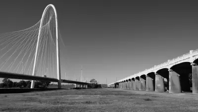
Robert Wilonsky reports on a recent meeting of the Dallas City Council’s Transportation and Trinity Corridor Project Committee, which brought to light new details of a proposal to build a “six-lane toll road the city along the east levee of the Trinity River between Interstate 45/U.S. 175 to the Interstate 35E and State Highway 183 merge.”
The meeting examined the proposed plan's final environmental impact statement, as prepared by the Federal Highway Administration. The crux of the controversy arising from the hearing: the proposed route's proximity to, and protection from, the Trinity River's floodplain. “For much of its nine-mile length, the road will extend around 535 feet into the floodway; there’s a plan for a ‘flood separation wall’ that’s not even as high as the existing levees; and in some instances the road runs almost right next to the river,” writes Wilonsky.
Wilonsky quotes the reaction of Dallas City Council member Scott Griggs, who has this to say about the project’s proposed flood control infrastructure: “This is the first time we got a sense of how far the road goes into the green space…And the flood wall only halfway up the levees. If you live near the levees you know why they’re as tall as they are, and not half their height. It gets up there, like it did in 1990. And now I am concerned about the safety of people using the road during storms.”
And here’s Dallas Morning News Architecture Critic Mark Lamster’s take on Wilonsky’s article and the toll road project, via Twitter:

The project still requires approval by the FHWA and the U.S. Army Corps of Engineers, which will release its own EIS later this week. The Trinity Toll Road project is connected to a plan to create a series of lakes as an open space resource, funded by $31.5 million in voter approved bond money from 1998.
FULL STORY: Trinity River toll road planner to Dallas City Council: Parkway could be swamped in a flood


Alabama: Trump Terminates Settlements for Black Communities Harmed By Raw Sewage
Trump deemed the landmark civil rights agreement “illegal DEI and environmental justice policy.”

Study: Maui’s Plan to Convert Vacation Rentals to Long-Term Housing Could Cause Nearly $1 Billion Economic Loss
The plan would reduce visitor accommodation by 25% resulting in 1,900 jobs lost.

Why Should We Subsidize Public Transportation?
Many public transit agencies face financial stress due to rising costs, declining fare revenue, and declining subsidies. Transit advocates must provide a strong business case for increasing public transit funding.

Paris Bike Boom Leads to Steep Drop in Air Pollution
The French city’s air quality has improved dramatically in the past 20 years, coinciding with a growth in cycling.

Why Housing Costs More to Build in California Than in Texas
Hard costs like labor and materials combined with ‘soft’ costs such as permitting make building in the San Francisco Bay Area almost three times as costly as in Texas cities.

San Diego County Sees a Rise in Urban Coyotes
San Diego County experiences a rise in urban coyotes, as sightings become prevalent throughout its urban neighbourhoods and surrounding areas.
Urban Design for Planners 1: Software Tools
This six-course series explores essential urban design concepts using open source software and equips planners with the tools they need to participate fully in the urban design process.
Planning for Universal Design
Learn the tools for implementing Universal Design in planning regulations.
Smith Gee Studio
Alamo Area Metropolitan Planning Organization
City of Santa Clarita
Institute for Housing and Urban Development Studies (IHS)
City of Grandview
Harvard GSD Executive Education
Toledo-Lucas County Plan Commissions
Salt Lake City
NYU Wagner Graduate School of Public Service