


A new study finds that surface topography, not solely an area's underlying geology, contributes significantly to earthquake intensity. Researchers hope that the new information can be easily factored into local planning and design processes.
By studying the seismic forces and patterns of destruction to the built environment stemming from the magnitude 7.0 earthquake in the Haitian capital of Port-au-Prince ten months ago, a team of researchers has found that certain local surface features of an area's topography can have a substantial effect on an earthquake's intensity. These findings have important implications for planning and design of the built environment, especially in places of high seismic activity that are at high-risk of facing earthquake damage in the future.
The research team, led by Susan E. Hough of the United States Geological Survey, examined relationships between various natural topographical features in Port-au-Prince and the level of destruction to the buildings and other manmade structures sitting atop them. Accompanying computer simulations created from real-world data were also created by the researchers to pinpoint just how much movement can be expected on a ridge or slope of a certain height, for example. The findings should assist planners and scientists working to map out regions of the city that are at a higher level of risk in future quakes. This process has been dubbed 'microzonation.'
"In Haiti specifically, Dr. Hough said, scientists developing microzonation maps can now incorporate the topographic effects seen along the ridge in their work to help the country rebuild properly and better survive the next earthquake. And future earthquakes on or near the same fault are inevitable, seismologists say. "Potentially you can say, 'You should build over here, and not there,' " she said."
FULL STORY: In Studying Haiti, a New Angle on an Earthquake's Intensity

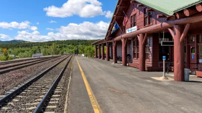
More Passenger Rail Coming to Montana
Planning is underway to restore a 45-year-defunct regional passenger rail line connecting southern Montana to Billings and Amtrak’s east-west Empire Builder line from Seattle to Chicago.

Elevating the ‘Small Stuff’ in Urban Design
Chuck Wolfe recaps arguments in favor of increased attention to incidentals — from benches to bollards — in urban development practices.

Los Angeles County Initiates Effort to Advance Equity in Infrastructure
L.A. County Public Works has launched an initiative to center equity in all of its processes, programming, and services as it plans, designs, builds, and maintains modern infrastructure that uplifts all communities of the county.

Study: Maui’s Plan to Convert Vacation Rentals to Long-Term Housing Could Cause Nearly $1 Billion Economic Loss
The plan would reduce visitor accommodation by 25,% resulting in 1,900 jobs lost.

Alabama: Trump Terminates Settlements for Black Communities Harmed By Raw Sewage
Trump deemed the landmark civil rights agreement “illegal DEI and environmental justice policy.”

Why Should We Subsidize Public Transportation?
Many public transit agencies face financial stress due to rising costs, declining fare revenue, and declining subsidies. Transit advocates must provide a strong business case for increasing public transit funding.

Paris Bike Boom Leads to Steep Drop in Air Pollution
The French city’s air quality has improved dramatically in the past 20 years, coinciding with a growth in cycling.

Why Housing Costs More to Build in California Than in Texas
Hard costs like labor and materials combined with ‘soft’ costs such as permitting make building in the San Francisco Bay Area almost three times as costly as in Texas cities.

San Diego County Sees a Rise in Urban Coyotes
San Diego County experiences a rise in urban coyotes, as sightings become prevalent throughout its urban neighbourhoods and surrounding areas.
Urban Design for Planners 1: Software Tools
This six-course series explores essential urban design concepts using open source software and equips planners with the tools they need to participate fully in the urban design process.
Planning for Universal Design
Learn the tools for implementing Universal Design in planning regulations.
Smith Gee Studio
Alamo Area Metropolitan Planning Organization
City of Santa Clarita
Institute for Housing and Urban Development Studies (IHS)
City of Grandview
Harvard GSD Executive Education
Toledo-Lucas County Plan Commissions
Salt Lake City
NYU Wagner Graduate School of Public Service