


Grist's David Roberts maps out why his neighborhood is not walkable and how it could be greatly improved with just a little extra infrastructural connectivity.
"As you can see it's a fairly discrete area, bounded on four sides by busy arterials. Inside those arterials, there's no reason you couldn't have a thriving community. It already has a decent walkability score. There are a couple of parks; Greenwood boasts several restaurants and cafes; Aurora has an array of big box retailers; there's a great supermarket just a few blocks north of 145th. There are more people coming in, too, as a series of condos are built along Linden.
But despite all the ingredients ... there is no such community. The first and primal cause is that there are no %*#! sidewalks. (You hear me Mayor McGinn? Show me what the new guy can do!) But I think the problems run deeper. Look closely at the map and you'll note that the development pattern is almost aggressively misanthropic. Everyone is isolated from everyone else."
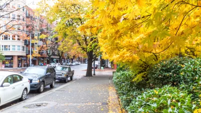
With streets that end just short of linking and few sidewalks, walking around and through the Bitter Lake neighborhood in Seattle is a challenge. Roberts offers a vision of how the street grid could be improved.
FULL STORY: Making my neighborhood more walkable, sociable, sustainable, and safe


Austin Suburb Launches Walkability Study
Kyle, Texas is developing a Sidewalks Master Plan to improve walking facilities.
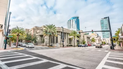
Orlando Pledges to Improve Walkability
A city report highlights successes and failures in building safer transportation infrastructure and reducing VMT in 2023.
Proposal Could Mandate Sidewalks as Part of Seattle Complete Streets
Almost a third of the city’s neighborhood streets lack sidewalks.

Alabama: Trump Terminates Settlements for Black Communities Harmed By Raw Sewage
Trump deemed the landmark civil rights agreement “illegal DEI and environmental justice policy.”

Planetizen Federal Action Tracker
A weekly monitor of how Trump’s orders and actions are impacting planners and planning in America.

How Atlanta Built 7,000 Housing Units in 3 Years
The city’s comprehensive, neighborhood-focused housing strategy focuses on identifying properties and land that can be repurposed for housing and encouraging development in underserved neighborhoods.

In Both Crashes and Crime, Public Transportation is Far Safer than Driving
Contrary to popular assumptions, public transportation has far lower crash and crime rates than automobile travel. For safer communities, improve and encourage transit travel.

Report: Zoning Reforms Should Complement Nashville’s Ambitious Transit Plan
Without reform, restrictive zoning codes will limit the impact of the city’s planned transit expansion and could exclude some of the residents who depend on transit the most.

Judge Orders Release of Frozen IRA, IIJA Funding
The decision is a victory for environmental groups who charged that freezing funds for critical infrastructure and disaster response programs caused “real and irreparable harm” to communities.
Urban Design for Planners 1: Software Tools
This six-course series explores essential urban design concepts using open source software and equips planners with the tools they need to participate fully in the urban design process.
Planning for Universal Design
Learn the tools for implementing Universal Design in planning regulations.
Caltrans
Smith Gee Studio
Institute for Housing and Urban Development Studies (IHS)
City of Grandview
Harvard GSD Executive Education
Toledo-Lucas County Plan Commissions
Salt Lake City
NYU Wagner Graduate School of Public Service