


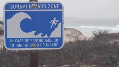
California has just completed a landmark effort to assess the state's worst-case tsunami danger. Now emergency response officials, and even some planners, are considering how to keep the state's coastal populations safe.
"Approximating maximum inundation for a worst-case scenario tsunami, the line washes over all of Newport Bay and Marina del Rey, wipes out parts of downtown Santa Cruz, and makes half of Seal Beach disappear. Some of the state's most fabled real estate from La Jolla to Malibu to Montecito would wash out with the tide. It would yet again pummel Crescent City, itself the victim of the nation's most destructive and deadly recorded tsunami, a 20-foot wave that struck on Good Friday, 1964."
"The maps assign to the tsunami threat a visual element that is absent from the prediction of earthquakes. Contrary to this discomfiting picture, however, researchers and state officials alike caution that the maps' projections in no way mean that the state's coastal communities and nearly 1 million coastal residents should permanently decamp for higher ground."
"Memories of the 2004 south Asian tsunami -- and of the statewide warnings that were sounded after the February 25 Chilean earthquake -- make clear the destructive threat of tsunamis. The maps were prompted by recommendations in a 2005 risk assessment report published by the state Seismic Safety Commission. That report, which was prompted by the south Asian event, noted that roughly 80 tsunamis have struck California over the past 150 years and that two of them were destructive."
Thanks to Josh Stephens
FULL STORY: New Tsunami Maps Depict Extreme High-Water Mark

Washington State Requests Federal Funding for Tsunami Preparedness
The state’s Department of Natural Resources says it needs continued funding to map coastal areas at risk for tsunami impacts and prepare mitigation and evacuation plans.

Austin Text Alert System Caters to Unhoused Residents
A new emergency text message alert system will provide information specific to the needs of homeless people during extreme weather events.

California Regulators Require Parking Replacement for Outdoor Dining Spaces
The city of San Diego’s Spaces as Places outdoor dining program includes a critical parking requirement mandated by the California Coastal Commission.

Alabama: Trump Terminates Settlements for Black Communities Harmed By Raw Sewage
Trump deemed the landmark civil rights agreement “illegal DEI and environmental justice policy.”

Study: Maui’s Plan to Convert Vacation Rentals to Long-Term Housing Could Cause Nearly $1 Billion Economic Loss
The plan would reduce visitor accommodation by 25% resulting in 1,900 jobs lost.

Planetizen Federal Action Tracker
A weekly monitor of how Trump’s orders and actions are impacting planners and planning in America.

Wind Energy on the Rise Despite Federal Policy Reversal
The Trump administration is revoking federal support for renewable energy, but demand for new projects continues unabated.

Passengers Flock to Caltrain After Electrification
The new electric trains are running faster and more reliably, leading to strong ridership growth on the Bay Area rail system.

Texas Churches Rally Behind ‘Yes in God’s Back Yard’ Legislation
Religious leaders want the state to reduce zoning regulations to streamline leasing church-owned land to housing developers.
Urban Design for Planners 1: Software Tools
This six-course series explores essential urban design concepts using open source software and equips planners with the tools they need to participate fully in the urban design process.
Planning for Universal Design
Learn the tools for implementing Universal Design in planning regulations.
Caltrans
Smith Gee Studio
Institute for Housing and Urban Development Studies (IHS)
City of Grandview
Harvard GSD Executive Education
Toledo-Lucas County Plan Commissions
Salt Lake City
NYU Wagner Graduate School of Public Service