


The federal tool used to inform flood protection spending calculates communities' risk by multiplying expected annual loss in dollars by their risk factor. As a result, many rural areas are classified as “low” risk, despite frequent, severe flooding.
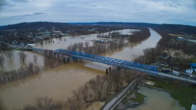
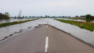
Daily Yonder, in a collaboration with Climate Central, published an article highlighting the “bias” in FEMA’s disaster assistance calculations, which it says could prevent rural regions from benefiting from flood mitigation projects funded by the Bipartisan Infrastructure Bill and future federal infrastructure funding. “FEMA developed its National Risk Index to help local and state officials and residents plan for emergencies through an online tool,” write authors Claire Carlson and Elizabeth Miller. The tool uses historic rainfall and other data to characterize risk and inform its spending decisions. The problem? Many rural communities, even those that have suffered from natural disasters like major flooding in the past, are still classified as “low” risk by the tool, “largely because they have less to lose — financially — compared to more urbanized areas,” according to the article.
The article offers in-depth examples of how this “bias” has played out in Eastern Kentucky, which floods on a regular basis but experienced a catastrophic flooding event two years ago. Despite this fact, FEMA’s National Risk Index classifies the 13 counties declared federal disaster areas two years ago as facing “low” or “very low” risks. That’s because the “National Risk Index multiplies a community’s expected annual loss in dollars by their risk factor,” according to the article, and the median household income and home values in those rural counties is significantly lower, in some cases up to half, of the national average.
“This urban-rural difference matters because FEMA uses the National Risk Index to determine how much money communities should receive to better prepare for natural disasters” the article reads.
Chad Berginnis, executive director of the Association of State Floodplain Managers, also told Daily Yonder and Climate Central: “There’s a bias against, I think, rural communities, especially in the flood dataset,” which he said could “profoundly” confuse or affect emergency managers in those areas. That tool is also “being used to make decisions about spending $1.2 trillion available to lessen future flood risks under the U.S. Infrastructure Investment and Jobs Act,” Carlson and Miller write, which could lead to underinvestment in rural communities.
This is also an important issue in the context of the housing affordability crisis. There is an urgency to build new, affordable housing units, but the cheapest and most readily available land to build on also tends to be the land most vulnerable to flooding and other hazards. Without accurate and unbiased data and risk calculation, there is a potential that a lot of that new housing could end up in areas that are at high-risk for climate-related disasters.
FULL STORY: The Rural Americans Too Poor for Federal Flood Protections

FEMA Extends Deadline for Hazard Mitigation Grant Applications
Tight applications prevented many communities struck by disasters from applying for FEMA resilience grants, so the agency issued a new rule that extended the application window.

From Crisis to Opportunity in Ukraine
Rebuilding in ways that are more environmentally, socially, and economically sustainable in the face of ongoing conflict.

New Data: Rural Remote Workers Concentrate in Recreation Hubs
Remote workers flock to ski towns, hiking spots and other popular recreation hubs.

Alabama: Trump Terminates Settlements for Black Communities Harmed By Raw Sewage
Trump deemed the landmark civil rights agreement “illegal DEI and environmental justice policy.”

Planetizen Federal Action Tracker
A weekly monitor of how Trump’s orders and actions are impacting planners and planning in America.

Why Should We Subsidize Public Transportation?
Many public transit agencies face financial stress due to rising costs, declining fare revenue, and declining subsidies. Transit advocates must provide a strong business case for increasing public transit funding.

Understanding Road Diets
An explainer from Momentum highlights the advantages of reducing vehicle lanes in favor of more bike, transit, and pedestrian infrastructure.

New California Law Regulates Warehouse Pollution
A new law tightens building and emissions regulations for large distribution warehouses to mitigate air pollution and traffic in surrounding communities.

Phoenix Announces Opening Date for Light Rail Extension
The South Central extension will connect South Phoenix to downtown and other major hubs starting on June 7.
Urban Design for Planners 1: Software Tools
This six-course series explores essential urban design concepts using open source software and equips planners with the tools they need to participate fully in the urban design process.
Planning for Universal Design
Learn the tools for implementing Universal Design in planning regulations.
Caltrans
Smith Gee Studio
Institute for Housing and Urban Development Studies (IHS)
City of Grandview
Harvard GSD Executive Education
Toledo-Lucas County Plan Commissions
Salt Lake City
NYU Wagner Graduate School of Public Service