


City Profiles
Explore cities through an urban planning lens.
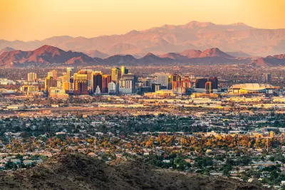
Phoenix: An Urban Planner's Guide to the City
A modern city with an ancient history, Phoenix became a booming desert oasis in the late 20th century. Now, extreme heat and dwindling water supplies require a new path forward.
Basics
- State: Arizona
- Incorporation date: February 25, 1881
- Area: 518.27 square miles
- Statehood: February 14, 1912
- Population*: 1,608,139
- Type of government: Council-manager
- Planning department website: Planning and Development Department
- Comprehensive plan: General Plan
*Current as of 2020 Census.
Phoenix's indigenous occupant history
The area now known as Phoenix, like much of the Southwest, has a rich and complex Native American history dating back thousands of years. The city is home to the largest pre-Columbian irrigation system in the Western Hemisphere. As early as 200 C.E., the Hohokam people built what became roughly 250 miles of irrigation channels to direct water from the Salt River. The Hohokam built villages divided into areas for different uses. They were part of extensive trade networks that reached across the Southwest and Mesoamerica.
The Hohokam abandoned the area around 1400 C.E. and were followed by the Akimel O’odham (or Pima), the Tohono O'odham, and Maricopa. These groups continued to irrigate and farm the area, growing crops such as corn, beans, and squash. The paths of irrigation canals originally built by the Hohokam people were later used for modern canals and aqueducts. Today, Arizona is home to 22 federally recognized tribes.
Colonization, the Mexican-American Civil War, and agriculture
The area became part of the Mexican Republic until the end of the Mexican-American War. The region then became part of the United States’ Arizona Territory. The area grew little until after the Civil War, when westward migration necessitated the construction of forts and settlements.
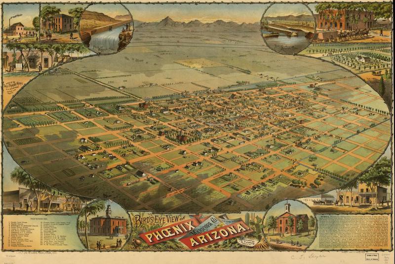
In the late 1860s, Jack Swilling took advantage of the ancient canals, coopting their routes to retrench irrigation systems, leading to an agricultural boom. In 1870, the area now known as the downtown business district became the first official townsite for Phoenix, administered by the Salt River Valley Town Association. The name is thought to come from the mythical beast that rises from its own ashes, implying a nod to the communities that previously lived in the same area. The city was laid out in a one-mile by half-mile grid.
20th century growth: Dams, air-conditioning, and affordability
The construction of dams on the Salt River led to the city’s growth in the early 20th century, and the Salt River Valley Waters Users' Association was established in 1903 to regulate and manage the local water supply. Phoenix became one of the first cities in the nation to adopt a council-manager government in 1913.
Early residents dealt with the extreme summer heat through an innovative technology known as evaporative cooling, a precursor to modern air conditioning. Phoenix touted itself as an ‘air-cooled city’ and became a hub for the air conditioning industry early in the 20th century. The city’s population and area grew exponentially after 1950 with the advent of ‘true’ A/C, more than quadrupling in population size between 1950 and 1960. Affordable housing and the presence of large employers made Phoenix an attractive destination for many American households and it became one of the success stories of the Sun Belt.
21st century concerns: Water demand, drought, and extreme heat
The most urgent challenge Phoenix faces is water management. As population and demand for water grow across the Southwest, states are fighting to retain as much water from the Colorado River and other sources as possible. Meanwhile, intense drought led to perilously low water levels in reservoirs such as Lake Mead and Lake Powell in recent years, posing a threat to hydroelectric production as well as water supplies.
Phoenix is experiencing more intense heat waves. The summer of 2024 set a new heat record for the second year in a row, with 113 straight days with temperatures over 100 degrees Fahrenheit. In 2023 became one of the first U.S. cities to create an Office of Heat Response and Mitigation to develop a strategy for handling extreme heat events.
Key planning milestones in Phoenix
- 1867: Jack Swilling forms the Swilling Irrigation and Canal Company and digs the first modern canal for farming irrigation.
- 1868: Yavapai County Board of Supervisors officially recognizes Phoenix as an election precinct.
- 1870: The Salt River Valley Town Association is formed to administer the new townsite.
- 1881: The city is incorporated under the Phoenix Charter Bill when the population reaches 2,500.
- 1887: First horse-drawn streetcar line is built along Washington Street.
- 1893: horse-drawn streetcars are replaced by electric cars.
- 1903: Salt River Valley Waters Users' Association is established to manage the water supply.
- 1913: The city adopts a new charter, creating a council-manager form of government.
- 1920: The city’s first skyscraper, the Heard Building, is constructed.
- 1948: Citizens vote to strengthen the City Manager position and increase the number of members on the City Council.
- 1979: Phoenix approves the Phoenix Concept Plan 2000, defining the boundaries of nine ‘urban villages.’
- 1985: The Central Arizona Project, a 330-mile canal from the Colorado River, begins delivering water to Phoenix.
- 1985: The Phoenix General Plan is adopted, superseding Phoenix Concept Plan 2000. The Phoenix Urban Village Model refines the original idea, providing guidance for development patterns based on principles that include balancing housing and jobs, concentrating intensity in village cores, and providing for a majority of residents’ needs within each village.
- 2021: Phoenix establishes Office of Heat Response and Mitigation, one of the first municipal departments tasked with addressing the impacts of extreme heat in the country.

They Had No Heat for Months. A New Law Let Them Sue.
In New York state, tenants can now take landlords to court directly to force repairs and get damages, without withholding rent first. Here’s how one of the first tests of the new law worked.
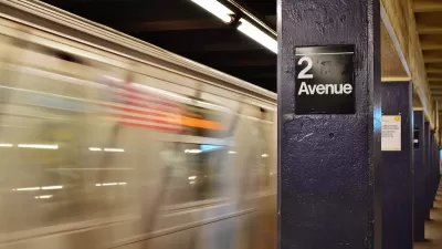
New York Governor Announces 2024 Transportation Plans
Gov. Hochul’s plans include the long-awaited Second Avenue Subway extension.

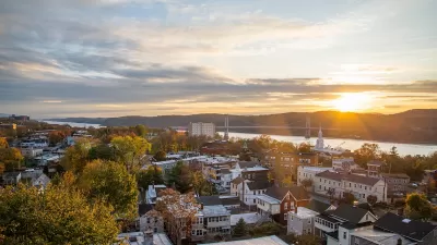
Main Street Redevelopment Hopes To Lure NYC Commuters to Village of Brewster
Officials in the Village of Brewster, a community of just over 2,000 people in New York's Putnam County, hope a redesign of their downtown will attract new residents who want to escape the clamor of the city.

Urban Design for Planners 1: Software Tools
This six-course series explores essential urban design concepts using open source software and equips planners with the tools they need to participate fully in the urban design process.
Planning for Universal Design
Learn the tools for implementing Universal Design in planning regulations.
Clanton & Associates, Inc.
Jessamine County Fiscal Court

Institute for Housing and Urban Development Studies (IHS)
City of Grandview
Harvard GSD Executive Education
Toledo-Lucas County Plan Commissions
Salt Lake City
NYU Wagner Graduate School of Public Service