


A massive effort is underway to compile local zoning regulations and other laws that impact how and where housing is built.
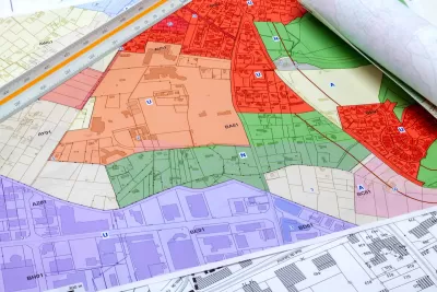
Historically left to local jurisdictions, zoning laws are now being assessed at the state and even national level as the housing crisis reaches all corners of the country. Could a ‘national zoning atlas’ spur change?
Kriston Capps describes the project in an article for Bloomberg CityLab, writing that “when complete, [the project] will offer users a neighborhood-level view of the zoning codes set by some 30,000 different local governments.” Teams in at least 25 states are working to compile this data, inspired by a Connecticut project. “[B]y pairing zoning maps with census data and other sources, researchers can shine a light on specific problems or places — and in at least a couple states so far, mapping out zoning codes has led to real change.”
The atlas could become an important tool because “Most local governments don’t fully understand their own zoning rules, which can be byzantine documents with fragmented, antiquated or contradictory rules accreted over decades.”
FULL STORY: Can a National Zoning Atlas Chart a Way Out of the US Housing Crisis?


California Housing Advocates Closely Watching Bay Area Rezoning Deadline
California’s reaction to cities that fail to submit compliant zoning plans could reverberate across the state as other regions near their deadlines.

The Rise of Zoning Reform
As the housing affordability crisis spread from mainly coastal cities to the rest of the nation, cities and states are taking a serious look at outdated zoning codes that hamper efforts to build more housing.
NYC Rezoning Plans Could Create Thousands of New Housing Units
Zoning changes in Brooklyn, the Bronx, and Midtown Manhattan would allow residential construction in areas previously zoned for light manufacturing.

Alabama: Trump Terminates Settlements for Black Communities Harmed By Raw Sewage
Trump deemed the landmark civil rights agreement “illegal DEI and environmental justice policy.”

Planetizen Federal Action Tracker
A weekly monitor of how Trump’s orders and actions are impacting planners and planning in America.

Why Should We Subsidize Public Transportation?
Many public transit agencies face financial stress due to rising costs, declining fare revenue, and declining subsidies. Transit advocates must provide a strong business case for increasing public transit funding.

Understanding Road Diets
An explainer from Momentum highlights the advantages of reducing vehicle lanes in favor of more bike, transit, and pedestrian infrastructure.

New California Law Regulates Warehouse Pollution
A new law tightens building and emissions regulations for large distribution warehouses to mitigate air pollution and traffic in surrounding communities.

Phoenix Announces Opening Date for Light Rail Extension
The South Central extension will connect South Phoenix to downtown and other major hubs starting on June 7.
Urban Design for Planners 1: Software Tools
This six-course series explores essential urban design concepts using open source software and equips planners with the tools they need to participate fully in the urban design process.
Planning for Universal Design
Learn the tools for implementing Universal Design in planning regulations.
Caltrans
Smith Gee Studio
Institute for Housing and Urban Development Studies (IHS)
City of Grandview
Harvard GSD Executive Education
Toledo-Lucas County Plan Commissions
Salt Lake City
NYU Wagner Graduate School of Public Service