


New research sheds light on how L.A.’s aging and poorly maintained infrastructure is putting hundreds of thousands more residents in flood hazard zones than previously estimated.
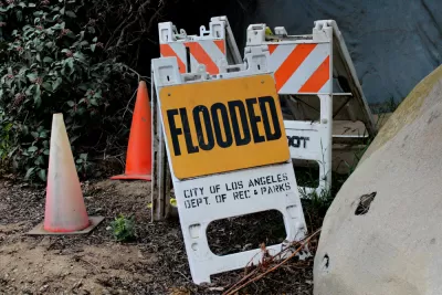
A new study warns that hundreds of thousands of Los Angeles residents are at risk for flooding, in part because of the city’s aging infrastructure, reports Raymond Zhang for the New York Times. The estimate far surpasses federal estimates, Zhong notes, “because the new study takes a more realistic view of the city’s water infrastructure, said the report’s lead author, Brett F. Sanders, a professor of civil and environmental engineering at the University of California, Irvine.”
The research team used lidar data to examine the city’s flood control channels, many of which are clogged with debris, and assess their true stormwater channeling potential. “Let’s not assume perfect performance from our infrastructure; let’s look at the most likely performance,” explained Dr. Sanders. “The researchers studied how water might move through the city by building a high-resolution topographic map, one that could show details as small as three meters across, or about 10 feet.”
Flooding is becoming a bigger threat to Angelenos as warmer air causes more intense winter rainstorms. “Today, California has a roughly 1-in-50 chance each year of experiencing another weekslong megastorm of comparable intensity, scientists estimated recently. Global warming has roughly doubled those odds compared with a century ago, they found.”
According to the article, the city’s low-income communities, many located near the Los Angeles and San Gabriel rivers, face some of the highest risk and costs for rebuilding and replacing damaged property. The mayor’s office says the city is working with the Army Corps of Engineers to update flood risk maps and develop new strategies for improving the city’s resilience to flooding.
FULL STORY: Aging Infrastructure May Create Higher Flood Risk in L.A., Study Finds

L.A. County Calls for Flood Control Improvements
Recently revealed estimates put far more people in the region at risk for catastrophic flooding than previously thought.
FEMA Suspends Flood Rebuilding Standard
The rule was designed to prevent the rebuilding of government-funded projects in areas prone to repeated floods.
FEMA Rule Calls for Updated Flood Modeling
Agency-funded projects will be required to be elevated at least 2 feet above the projected local flood level.

Alabama: Trump Terminates Settlements for Black Communities Harmed By Raw Sewage
Trump deemed the landmark civil rights agreement “illegal DEI and environmental justice policy.”

Study: Maui’s Plan to Convert Vacation Rentals to Long-Term Housing Could Cause Nearly $1 Billion Economic Loss
The plan would reduce visitor accommodation by 25% resulting in 1,900 jobs lost.

Why Should We Subsidize Public Transportation?
Many public transit agencies face financial stress due to rising costs, declining fare revenue, and declining subsidies. Transit advocates must provide a strong business case for increasing public transit funding.

Paris Bike Boom Leads to Steep Drop in Air Pollution
The French city’s air quality has improved dramatically in the past 20 years, coinciding with a growth in cycling.

Why Housing Costs More to Build in California Than in Texas
Hard costs like labor and materials combined with ‘soft’ costs such as permitting make building in the San Francisco Bay Area almost three times as costly as in Texas cities.

San Diego County Sees a Rise in Urban Coyotes
San Diego County experiences a rise in urban coyotes, as sightings become prevalent throughout its urban neighbourhoods and surrounding areas.
Urban Design for Planners 1: Software Tools
This six-course series explores essential urban design concepts using open source software and equips planners with the tools they need to participate fully in the urban design process.
Planning for Universal Design
Learn the tools for implementing Universal Design in planning regulations.
Smith Gee Studio
Alamo Area Metropolitan Planning Organization
City of Santa Clarita
Institute for Housing and Urban Development Studies (IHS)
City of Grandview
Harvard GSD Executive Education
Toledo-Lucas County Plan Commissions
Salt Lake City
NYU Wagner Graduate School of Public Service