


A 1971 effort to quantify the city's values and design goals reflects many of the same priorities that planners and residents face today.
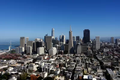
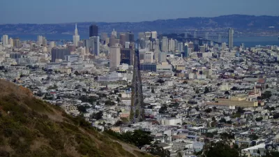
In 1971, San Francisco published its Urban Design Plan, a blueprint for preserving the character of the city and addressing growing concerns about building height and density. John King describes the plan, which warned against "unstructured and unabated growth" and the "jarring disharmony" caused by 'unusual' buildings like the Transamerica Pyramid, approved for construction in 1969.
The plan also acknowledged the role of high-rises in the growing city, "a necessary and expressive form for much of the city’s office, apartment, hotel and institutional development," and encourages 'respectful' new development that fits into the city's unique environment.
The plan includes a wealth of photos, sketches, and maps that illustrate the planners' ideas about creating a pleasant urban environment and their design best-practices.
Notably, the plan calls for reducing traffic in residential areas through what we now call traffic calming measures such as narrowed streets, landscaping, and traffic diversion. Planners in 1971 also suggested "close by and visible" parks, pointing to the city's waterfront as an underused recreational space. As King notes, "This was written 20 years before the Embarcadero Freeway was torn down, and 30 years before Crissy Field opened in the Presidio."
The conclusion we can draw from the plan more broadly, writes King, is the idea that the city's fractious population can come to some agreement on what they value in their built environment—and that San Franciscans love their city enough to fight for it.
FULL STORY: Planners tried to define what makes San Francisco special — in 1971. Here’s how their designs fared

San Francisco Could Strike Deal on New Tower
The city is leveraging height increases and density bonuses to acquire more properties for affordable housing.
How the Built Environment Impacts Public Health
New research sheds light on how the brain responds to urban environments and architecture.
Is it Time to Revive the Pattern Language?
Software and other fields have made brilliant progress with the pattern language methodology, while built environment fields lag badly, mired in parochial debates over the massive book that invented the methodology.

Study: Maui’s Plan to Convert Vacation Rentals to Long-Term Housing Could Cause Nearly $1 Billion Economic Loss
The plan would reduce visitor accommodation by 25,% resulting in 1,900 jobs lost.

North Texas Transit Leaders Tout Benefits of TOD for Growing Region
At a summit focused on transit-oriented development, policymakers discussed how North Texas’ expanded light rail system can serve as a tool for economic growth.

Using Old Oil and Gas Wells for Green Energy Storage
Penn State researchers have found that repurposing abandoned oil and gas wells for geothermal-assisted compressed-air energy storage can boost efficiency, reduce environmental risks, and support clean energy and job transitions.

Santa Barbara Could Build Housing on County Land
County supervisors moved forward a proposal to build workforce housing on two county-owned parcels.

San Mateo Formally Opposes Freeway Project
The city council will send a letter to Caltrans urging the agency to reconsider a plan to expand the 101 through the city of San Mateo.

A Bronx Community Fights to Have its Voice Heard
After organizing and giving input for decades, the community around the Kingsbridge Armory might actually see it redeveloped — and they want to continue to have a say in how it goes.
Urban Design for Planners 1: Software Tools
This six-course series explores essential urban design concepts using open source software and equips planners with the tools they need to participate fully in the urban design process.
Planning for Universal Design
Learn the tools for implementing Universal Design in planning regulations.
Ascent Environmental
Borough of Carlisle
Institute for Housing and Urban Development Studies (IHS)
City of Grandview
Harvard GSD Executive Education
Toledo-Lucas County Plan Commissions
Salt Lake City
NYU Wagner Graduate School of Public Service