


The New York Department of City Planning has taken its open data practices to a new level with the launch of the Capital Planning Explorer.

The New Your City Department of City Planning (DCP) last week launched the Capital Planning Explorer, a new, map-based website aimed at increasing transparency around capital planning, according to a DCP press release. The Capital Planning Explorer website describes the new tool as "a place for the public and planners to access the maps and data that they need to better plan for investments in neighborhoods and collaborate with one another."
The map offers three layers: Capital Projects, Facilities, and New Housing Developments. The Housing Development maps, for example, include all housing permits in all five boroughs, color-coded by new construction, building alterations, or demolitions. "This supplemental information on the number and types of housing units found on any city block is key to the city’s planning processes for capital projects," according to the website.
According to the Capital Planning Explorer website, the tool uses derived from the Capital Commitment Plan published by the city's Office of Management and Budget (OMB), in addition to supporting data from Checkbook NYC, a resource provided by the comptroller, and spatial data from but not limited to data created and published by DDC, DPR,ORR, and DCP. All datasets are available for download.
The press release included soundbites from DCP Director Anita Laremont, who touts the new tool as emblematic of work by the DCP to build more trust and transparency.
FULL STORY: A NEW DIGITAL TOOL FOR THE PUBLIC: DCP Launches Capital Planning Explorer

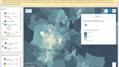
Smart Growth Loves Heatmaps
Smart growth can provide many important benefits that are easy to see using informative and beautiful heatmaps—our complex world as viewed by all-knowing gods.
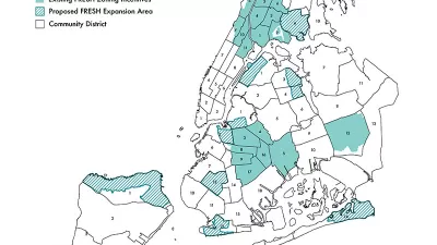
Zoning Incentives for Supermarkets: New York Expands its FRESH Program
The FRESH program, previously offering zoning incentives for grocery store development in 19 districts around New York City, will expand to 11 new locations.

Lawsuit Challenges Zoom Hearings on Gowanus Rezoning Plan
Planning departments relying on online public hearing processes will want to keep monitor this lawsuit in New York City.

Alabama: Trump Terminates Settlements for Black Communities Harmed By Raw Sewage
Trump deemed the landmark civil rights agreement “illegal DEI and environmental justice policy.”

Planetizen Federal Action Tracker
A weekly monitor of how Trump’s orders and actions are impacting planners and planning in America.

Why Should We Subsidize Public Transportation?
Many public transit agencies face financial stress due to rising costs, declining fare revenue, and declining subsidies. Transit advocates must provide a strong business case for increasing public transit funding.

Understanding Road Diets
An explainer from Momentum highlights the advantages of reducing vehicle lanes in favor of more bike, transit, and pedestrian infrastructure.

New California Law Regulates Warehouse Pollution
A new law tightens building and emissions regulations for large distribution warehouses to mitigate air pollution and traffic in surrounding communities.

Phoenix Announces Opening Date for Light Rail Extension
The South Central extension will connect South Phoenix to downtown and other major hubs starting on June 7.
Urban Design for Planners 1: Software Tools
This six-course series explores essential urban design concepts using open source software and equips planners with the tools they need to participate fully in the urban design process.
Planning for Universal Design
Learn the tools for implementing Universal Design in planning regulations.
Caltrans
Smith Gee Studio
Institute for Housing and Urban Development Studies (IHS)
City of Grandview
Harvard GSD Executive Education
Toledo-Lucas County Plan Commissions
Salt Lake City
NYU Wagner Graduate School of Public Service