


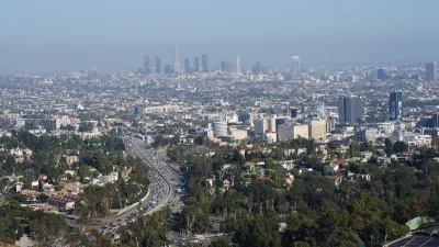
Google has unveiled a new tool called Tree Canopy Lab in an effort to keep cities like Los Angeles cool by helping them to know where to plant more trees.

Many of us would probably agree that planting more trees is a good thing. Cities tend to be warmer than surrounding areas because buildings and asphalt trap heat, resulting in the urban heat island effect. One way to cool urban areas down is to plant more trees in neighborhoods where they are sparse.
The challenge is knowing where to plant trees strategically to benefit those who need them most. As Justine Calma explains in this article, Google has released a tool that can help. Specifically, Google's new Tree Canopy Lab can help cities keep their residents cool by mapping out where trees are needed most.
Tree Canopy Lab uses aerial imagery and Google’s artificial intelligence to figure out where every tree is in a city. The tool then puts that information on an interactive map along with additional data layers on which neighborhoods are more densely populated and are more vulnerable to high temperatures. The idea is that planting new trees in these areas can help cities adapt to a warming world and save lives during heat waves.
Google piloted Tree Canopy Lab in Los Angeles. Data on hundreds more cities is on the way. Tree Canopy Lab found that over half of L.A. residents live in places where trees shade less than 10 percent of their neighborhood. It also found that 44 percent of Angelenos live in places with extreme heat risk. Heat waves in Los Angeles County have gotten longer, more frequent, and more intense over the past 50 years.
FULL STORY: Google launches new tool to help cities stay cool

Updating LA’s Tree Rules Could Bring More Shade to Underserved Neighborhoods
A new USC study finds that relaxing Los Angeles’ outdated tree planting guidelines could significantly expand urban tree canopy and reduce shade disparities in lower-income neighborhoods, though infrastructure investments are also needed.

Improving South Los Angeles Through Strategic Tree Planting
The University of Southern California Urban Trees Initiative is planting 250 trees in South L.A. neighborhoods to improve shade, combat climate change, and enhance community well-being through collaboration and data-driven approaches.
Invasive Beetles Put Oregon Forests at Risk
Two recently discovered borer beetles could lead to a significant loss of tree canopy.

Alabama: Trump Terminates Settlements for Black Communities Harmed By Raw Sewage
Trump deemed the landmark civil rights agreement “illegal DEI and environmental justice policy.”

Planetizen Federal Action Tracker
A weekly monitor of how Trump’s orders and actions are impacting planners and planning in America.

How Atlanta Built 7,000 Housing Units in 3 Years
The city’s comprehensive, neighborhood-focused housing strategy focuses on identifying properties and land that can be repurposed for housing and encouraging development in underserved neighborhoods.

In Both Crashes and Crime, Public Transportation is Far Safer than Driving
Contrary to popular assumptions, public transportation has far lower crash and crime rates than automobile travel. For safer communities, improve and encourage transit travel.

Report: Zoning Reforms Should Complement Nashville’s Ambitious Transit Plan
Without reform, restrictive zoning codes will limit the impact of the city’s planned transit expansion and could exclude some of the residents who depend on transit the most.

Judge Orders Release of Frozen IRA, IIJA Funding
The decision is a victory for environmental groups who charged that freezing funds for critical infrastructure and disaster response programs caused “real and irreparable harm” to communities.
Urban Design for Planners 1: Software Tools
This six-course series explores essential urban design concepts using open source software and equips planners with the tools they need to participate fully in the urban design process.
Planning for Universal Design
Learn the tools for implementing Universal Design in planning regulations.
Jessamine County Fiscal Court
Caltrans
Institute for Housing and Urban Development Studies (IHS)
City of Grandview
Harvard GSD Executive Education
Toledo-Lucas County Plan Commissions
Salt Lake City
NYU Wagner Graduate School of Public Service