


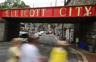
Ellicott City, Maryland, a suburb located 12-miles from Baltimore with a historic Main Street that has experienced catastrophic flooding twice since 2016, offers a case study of the complementary effects of sprawl and climate change.
Two national feature stories explore the sage of Ellicott City, a Maryland suburb that has on several occasions been made into a poster child for the need to prepare for climate change, extreme weather, and the failures of past planning.
Rebecca Hersher and Ryan Kellman report for an interactive feature, published by NPR, with testimonials, maps, and harrowing videos of stormwaters repeatedly flooding down the city's historic Main Street, destroying property and taking lives.
After floods in 2016 and 2018, county officials decided to create a new stormwater plan that would require removing ten buildings on Main Street to make room for floodwaters.
"The original plan, calling for 10 buildings to be removed, would reduce the water level to about 5 feet if a similar flood happened again," according to the article. Eight feet of water had flooded Main Street in 2016.
The idea brought serious blowback on social media and in the town, and the city went back to the drawing board.
"On May 13, 2019, the county announced the final flood plan for Old Ellicott City. It will spend at least $113 million to tear down four buildings on lower Main Street and bore one tunnel," report Hesher and Kellman.
In a separate article by Amy Plitt, published by Curbed, the story focuses a little more on the flooding as a consequence of sprawl and climate change.
First, there's the effect of sprawl in the mix of factors that created the terrible scenes on Main Street in Ellicott City in 2016 and again in 2018:
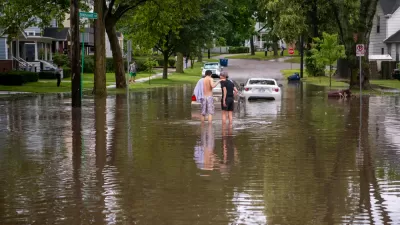
The historic center of Ellicott City was clobbered, in part, because of the suburban developments that sprung up around the town after 1960. Farmland and forests were replaced with housing, driveways, and big-box shopping centers with hundreds of parking spaces, creating geographical conditions that exacerbate the impacts of weather events like severe storms. That suburban sprawl is, on a larger scale, contributing to climate change—and there are some who think Ellicott City needs to do more to curb it.
Then there's a fact that is also true of many other cities in the United States: there's just more rain.
According to the National Climate Assessment, 'heavy rainfall events have increased' in the Northeast—which the assessment defines as the area spanning from Maryland to Maine—more than in any other region in the country. "The amount of rain that falls during these events increased by 70 percent between 1958 and 2010."
FULL STORY: After the Water


Maryland's Floods a Terrible Tragedy, and a Sign of More to Come
The sprawling, asphalt communities of U.S. cities, built as a result of mid-20th century planning, will meet terrible consequences during the extreme weather events of climate change.
A Natural Approach to Stormwater Proposed in Michigan
The realities of climate change have been on full display in Michigan this summer, and a crusading drain commissioner is pushing for stormwater infrastructure that uses natural features to capture and reuse water during extreme weather.
'Zoning for Coastal Flood Resiliency' Wins Planning Commission Approval in NYC
Emergency responses to Hurricane Sandy have turned into long-term lessons in New York City, as the nation's largest city crafts a response to sea-level rise and extreme weather by making changes to the zoning code of coastal areas.

Alabama: Trump Terminates Settlements for Black Communities Harmed By Raw Sewage
Trump deemed the landmark civil rights agreement “illegal DEI and environmental justice policy.”

Planetizen Federal Action Tracker
A weekly monitor of how Trump’s orders and actions are impacting planners and planning in America.

Why Should We Subsidize Public Transportation?
Many public transit agencies face financial stress due to rising costs, declining fare revenue, and declining subsidies. Transit advocates must provide a strong business case for increasing public transit funding.

Blinded by the Light: When Brighter Headlights Decrease Safety
Bright LED headlights can create glare and reduce visibility for other drivers and pedestrians.

Study Links Covid and Poor Driving
The effects of the virus, including ‘brain fog,’ can make driving more difficult and dangerous.

Waymo Gets Permission to Map SF’s Market Street
If allowed to operate on the traffic-restricted street, Waymo’s autonomous taxis would have a leg up over ride-hailing competitors — and counter the city’s efforts to grow bike and pedestrian on the thoroughfare.
Urban Design for Planners 1: Software Tools
This six-course series explores essential urban design concepts using open source software and equips planners with the tools they need to participate fully in the urban design process.
Planning for Universal Design
Learn the tools for implementing Universal Design in planning regulations.
Caltrans
Smith Gee Studio
Institute for Housing and Urban Development Studies (IHS)
City of Grandview
Harvard GSD Executive Education
Toledo-Lucas County Plan Commissions
Salt Lake City
NYU Wagner Graduate School of Public Service