


The San Francisco Bay has 400 miles of shoreline, and a dire need for a new approach to dealing with the effects of rising water levels. An estimated $100 billion in potential property damage is at risk.
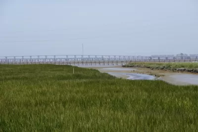
"A blueprint outlining how San Francisco Bay communities should combat sea-level rise was released early Thursday by ecosystem scientists and urban planners who envision a ring of man-made reefs, rocky beaches and graded marshlands around the largest estuary on the Pacific coast," reports Peter Fimrite.
The San Francisco Estuary Institute and SPUR created the San Francisco Bay Shoreline Adaptation Atlas [pdf], proposing major changes to existing seawalls, rip rap, culverts and other fortifications that are unlikely to weather the impacts of rising seas.
"The idea […] is to build eco-friendly features that support wildlife and absorb, rather than repel, the rising tides," explains Fimrite.
"The plan, funded by the San Francisco Bay Regional Water Quality Control Board, is the first attempt in the Bay Area to develop a collaborative regional plan to both enhance the ecosystem and protect cities around the bay from the potential ravages of climate change."

S.F. Plan Amendment to Allow Bay Filling
A revision to the region’s plan for the bay will allow areas to be filled in to create habitats that mitigate the effects of climate change.

Living Shorelines for Storm and Flood Protection
More coastal cities and communities are turning to the "soft" solutions of living shorelines—relying on "a combination of oyster reefs, oyster shells, rocks, marsh plants, and other natural materials can be an effective alternative to seawalls."
Bay Area Election Roundup: Wetlands, Housing, Ballot-Box Planning, Sales Tax
A regional measure to tax all property owners in the 9-county Bay Area to adapt to sea level rise passes; S.F. voters support raising the affordable housing bar; Richmond voters reject ballot-box planning; San José approves sales tax increase.

Alabama: Trump Terminates Settlements for Black Communities Harmed By Raw Sewage
Trump deemed the landmark civil rights agreement “illegal DEI and environmental justice policy.”

Study: Maui’s Plan to Convert Vacation Rentals to Long-Term Housing Could Cause Nearly $1 Billion Economic Loss
The plan would reduce visitor accommodation by 25% resulting in 1,900 jobs lost.

Planetizen Federal Action Tracker
A weekly monitor of how Trump’s orders and actions are impacting planners and planning in America.

Waymo Gets Permission to Map SF’s Market Street
If allowed to operate on the traffic-restricted street, Waymo’s autonomous taxis would have a leg up over ride-hailing competitors — and counter the city’s efforts to grow bike and pedestrian on the thoroughfare.

Parklet Symposium Highlights the Success of Shared Spaces
Parklets got a boost during the Covid-19 pandemic, when the concept was translated to outdoor dining programs that offered restaurants a lifeline during the shutdown.

Federal Homelessness Agency Places Entire Staff on Leave
The U.S. Interagency Council on Homelessness is the only federal agency dedicated to preventing and ending homelessness.
Urban Design for Planners 1: Software Tools
This six-course series explores essential urban design concepts using open source software and equips planners with the tools they need to participate fully in the urban design process.
Planning for Universal Design
Learn the tools for implementing Universal Design in planning regulations.
Caltrans
Smith Gee Studio
Institute for Housing and Urban Development Studies (IHS)
City of Grandview
Harvard GSD Executive Education
Toledo-Lucas County Plan Commissions
Salt Lake City
NYU Wagner Graduate School of Public Service