


Liberty Street was once a narrow, urban street. Now it's seven lanes of unsafe speeds and pedestrian risks. The city has a plan to greatly reduce the number of traffic lanes on the street, or another plan that won't.
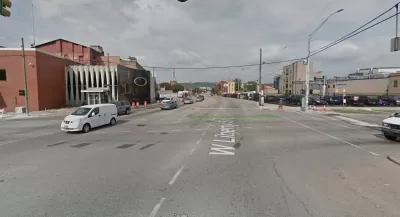
"A years-in-the-making redesign of Liberty Street -- one of Cincinnati's most vital and heavily-traveled roads -- might have taken one step closer to reality this week," reports Pat LaFleur.
Or not. There is plenty of reason to be skeptical about the likelihood of the project ever reaching completion, according to LaFleur. Local residents have been calling for the road diet to reduce speeds and increase safety for all users for years. According to data from the Cincinnati Police Department, Liberty Street has seen 1,700 traffic collisions since 2013, 30 involving pedestrians.
The city is currently considering two plans for the seven-lane street. One is the "road diet" configuration, which would shrink the road to five vehicle travel lanes. That alternative has support from a supermajority of Cincinnati councilmembers. The other planwould preserve all seven vehicle travel lanes, but add bump-outs at six intersections along the street. That plan has the support of Mayor John Cranley.
"The biggest conflict still stirring among lawmakers centers around what is a perpetual challenge for Over-the-Rhine: on-street parking," according to LaFleur. "Cranley's argument -- as well as several speakers at Monday's hearing -- is that the neighborhood cannot afford to lose all-day on-street parking."
FULL STORY: Will Liberty Street ever get its 'road diet'?

Planning for Congestion Relief
The third and final installment of Planetizen's examination of the role of the planning profession in both perpetuating and solving traffic congestion.
How Planning Fails to Solve Congestion
Solutions for congestion are never as simple and easy as armchair planners and engineers would like you to believe—especially those who suggest that congestion can be solved by forever building more roadway capacity.
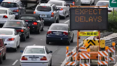
Planning and the Complicated Causes and Effects of Congestion
What do planners know about congestion, and what can they do about it? Explanations and solutions are less obvious than they seem (part one of a three-part series).

Alabama: Trump Terminates Settlements for Black Communities Harmed By Raw Sewage
Trump deemed the landmark civil rights agreement “illegal DEI and environmental justice policy.”

Planetizen Federal Action Tracker
A weekly monitor of how Trump’s orders and actions are impacting planners and planning in America.

How Atlanta Built 7,000 Housing Units in 3 Years
The city’s comprehensive, neighborhood-focused housing strategy focuses on identifying properties and land that can be repurposed for housing and encouraging development in underserved neighborhoods.

In Both Crashes and Crime, Public Transportation is Far Safer than Driving
Contrary to popular assumptions, public transportation has far lower crash and crime rates than automobile travel. For safer communities, improve and encourage transit travel.

Report: Zoning Reforms Should Complement Nashville’s Ambitious Transit Plan
Without reform, restrictive zoning codes will limit the impact of the city’s planned transit expansion and could exclude some of the residents who depend on transit the most.

Judge Orders Release of Frozen IRA, IIJA Funding
The decision is a victory for environmental groups who charged that freezing funds for critical infrastructure and disaster response programs caused “real and irreparable harm” to communities.
Urban Design for Planners 1: Software Tools
This six-course series explores essential urban design concepts using open source software and equips planners with the tools they need to participate fully in the urban design process.
Planning for Universal Design
Learn the tools for implementing Universal Design in planning regulations.
Jessamine County Fiscal Court
Caltrans
Institute for Housing and Urban Development Studies (IHS)
City of Grandview
Harvard GSD Executive Education
Toledo-Lucas County Plan Commissions
Salt Lake City
NYU Wagner Graduate School of Public Service