


Google's Environmental Insights Explorer multiplies the power of Google Maps for the benefit of the planet.

"Looking at a city’s Google Maps data, in combination with other data, a new tool from Google can estimate the carbon footprint of all of its buildings–and the carbon footprint of all the car trips, bus and subway rides, and other transportation used by the people living there," reports Adele Peters.
The new tool, called the Environmental Insights Explorer, launched in beta on September 10, and designed to help cities account for carbon emissions—accounting being an initial step before reductions can be made. The accounting process can be labor intensive and expensive—now Google has covered a large portion of the expense, free of cost.
FULL STORY: A new use for Google Maps: calculating a city’s carbon footprint


One U.S. State Boasts 33% Fewer Carbon Emissions Per Capita Than Any Other
California, the largest state by population in the United States, is responsible for 33% fewer carbon emissions per capita than any other state, according to a new study published in the Proceedings of the National Academy of Sciences.
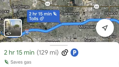
Google Maps Feature Identifies Most Fuel-Efficient Routes
A new feature highlights routes that use the least gas to help users make the most fuel-efficient driving decisions.

Mapping Climate Impact at the Neighborhood Level
A consumption-based analysis illustrates the differences in average household emissions across census tracts.

Alabama: Trump Terminates Settlements for Black Communities Harmed By Raw Sewage
Trump deemed the landmark civil rights agreement “illegal DEI and environmental justice policy.”

Planetizen Federal Action Tracker
A weekly monitor of how Trump’s orders and actions are impacting planners and planning in America.

Why Should We Subsidize Public Transportation?
Many public transit agencies face financial stress due to rising costs, declining fare revenue, and declining subsidies. Transit advocates must provide a strong business case for increasing public transit funding.

Understanding Road Diets
An explainer from Momentum highlights the advantages of reducing vehicle lanes in favor of more bike, transit, and pedestrian infrastructure.

New California Law Regulates Warehouse Pollution
A new law tightens building and emissions regulations for large distribution warehouses to mitigate air pollution and traffic in surrounding communities.

Phoenix Announces Opening Date for Light Rail Extension
The South Central extension will connect South Phoenix to downtown and other major hubs starting on June 7.
Urban Design for Planners 1: Software Tools
This six-course series explores essential urban design concepts using open source software and equips planners with the tools they need to participate fully in the urban design process.
Planning for Universal Design
Learn the tools for implementing Universal Design in planning regulations.
Caltrans
Smith Gee Studio
Institute for Housing and Urban Development Studies (IHS)
City of Grandview
Harvard GSD Executive Education
Toledo-Lucas County Plan Commissions
Salt Lake City
NYU Wagner Graduate School of Public Service