


Across the country, state and local governments have turned to AI to optimize their building permitting processes. The efficiencies they’ve achieved are impressive and welcomed by applicants and government agencies alike.
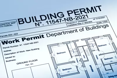
A recent article in GovTech explores how state and local governments are integrating AI and GIS into their permitting systems to expedite the process and improve accountability. According to staff writer Ashley Silver, “GIS- and AI-powered tools are increasingly resolving longstanding issues in state and local government permitting, giving jurisdictions the firepower to do better at automating processes, improving response times and empowering residents to complete their own applications.”
Silver highlights the Honolulu Department of Planning and Permitting, which is working with the CLARITI system to expedite building permit processing inspections and enforcement — which they identified as a bottleneck — via online customer portals and integrated land management tools.” Since the pilot launched in February, Silver reports that the time to complete residential permits have been cut by 70 percent. She adds that HDPP is now exploring a front-end AI component “not unlike TurboTax” that would “ensure permit applications meet all necessary requirements before being transferred into CLARITI for completion.”
Processing time for permits have also fallen by more than 70 percent in Virginia, where the Office of Regulatory Management used AI and GIS to create the Virginia Permit Transparency platform, which allows users to track their permit application status and maps out the timeline of permit steps, both targeted and actual. Maricopa County, Arizona, also launched a Permit Center platform just last June, which consolidates all existing permitting systems from other departments into a central platform for permit reviews, inspections and payments. It’s a “one-stop-shop” that not only offers better visibility into applications but also where residents can “pay fees online, schedule inspections and see what plan modifications are needed.”
AI is rapidly becoming a valuable tool for state and local governments; in addition to fast-tracking permitting, cities are using AI to build predictive models, identify wildfire risks, aid in traffic management, manage utilities, identify homeless camps, analyze public comments, ticket cars parked in bike lanes, and more. But as the adoption of AI technology becomes more widespread, government officials across the country are making plans to ensure it’s done responsibly, particularly given AI’s tendency for bias.
FULL STORY: How Governments Are Using AI and GIS to Fast-Track Permits


Ratepayers Could Be on the Hook for Data Centers’ Energy Use
Without regulatory changes, data centers’ high demand for energy would be subsidized by taxpayers, according to a new study.

Cities and States Taking Action to Limit Rent-Setting AI
Federal prosecutors are charging a software company with using algorithms to artificially inflate rents.

How AI Can Improve Public Transit
Machine learning and AI can transform the way transit agencies operate and make service faster and more comfortable for users.

Study: Maui’s Plan to Convert Vacation Rentals to Long-Term Housing Could Cause Nearly $1 Billion Economic Loss
The plan would reduce visitor accommodation by 25,% resulting in 1,900 jobs lost.

North Texas Transit Leaders Tout Benefits of TOD for Growing Region
At a summit focused on transit-oriented development, policymakers discussed how North Texas’ expanded light rail system can serve as a tool for economic growth.

Using Old Oil and Gas Wells for Green Energy Storage
Penn State researchers have found that repurposing abandoned oil and gas wells for geothermal-assisted compressed-air energy storage can boost efficiency, reduce environmental risks, and support clean energy and job transitions.

Private Donations Propel Early Restoration of Palisades Playground
Los Angeles has secured over $1.3 million in private funding to restore the Pacific Palisades playground months ahead of schedule, creating a modern, accessible space that supports community healing after recent wildfires.

From Blight to Benefit: Early Results From California’s Equitable Cleanup Program
The Equitable Community Revitalization Grant (ECRG) program is reshaping brownfield redevelopment by prioritizing projects in low-income and environmental justice communities, emphasizing equity, transparency, and community benefits.

Planting Relief: Tackling Las Vegas Heat One Tree at a Time
Nevada Plants, a Las Vegas-based nonprofit, is combating the city’s extreme urban heat by giving away trees to residents in underserved neighborhoods, promoting shade, sustainability, and community health.
Urban Design for Planners 1: Software Tools
This six-course series explores essential urban design concepts using open source software and equips planners with the tools they need to participate fully in the urban design process.
Planning for Universal Design
Learn the tools for implementing Universal Design in planning regulations.
Ascent Environmental
Borough of Carlisle
Institute for Housing and Urban Development Studies (IHS)
City of Grandview
Harvard GSD Executive Education
Toledo-Lucas County Plan Commissions
Salt Lake City
NYU Wagner Graduate School of Public Service