


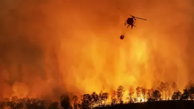
The state is pioneering the use of technology to identify wildfire risks and alert firefighters before blazes get out of control.

California fire officials are using artificial intelligence to get ahead of wildfires and help firefighters identify signs of fires before they rage out of control.
As Carl Smith explains in Governing, “The cameras, trained using artificial intelligence to recognize anomalies that could be signs of wildfire, make up part of an interlinked technology network that is redefining the scope of fire prediction, prevention and response.”
Technology can help officials understand conditions that pose fire risk, identify hazardous spots early, and track fire movement. “California is at the leading edge of implementing and integrating these tools, and officials are eager to share what they’re learning.”
As Smith explains, “It’s too much to ask humans to pay close attention to feeds from a thousand cameras at every hour of every day. If AI could learn what kinds of anomalies in a landscape might signify fire, the network could alert staff at command centers, where experienced firefighters could interpret what it had flagged.”
CAL FIRE’s innovative use of AI could serve as a model for other states. However, “No one thinks AI or other technology alone will provide a complete solution for California’s wildfire problem. Cameras are still being trained. They can spot something that might be a fire, but it takes an experienced firefighter to evaluate what they have flagged. Sightings by firefighters and volunteers in the field and in observation towers, as well as 911 calls from citizens and pilots, remain essential.”
FULL STORY: California's High Tech Approach to Preventing Wildfires

California Fire Dashboard Tracks Statewide Resilience Efforts
The online map builds a comprehensive database of fire prevention and mitigation efforts at every level of government to help agencies coordinate their work and understand the impacts of projects.

The Lesser-Known Programs in the Infrastructure Bill
While the focus has been on flashier components of the infrastructure bill, some smaller initiatives could have outsized impacts by shifting priorities and funding resilience efforts.

Ratepayers Could Be on the Hook for Data Centers’ Energy Use
Without regulatory changes, data centers’ high demand for energy would be subsidized by taxpayers, according to a new study.

Alabama: Trump Terminates Settlements for Black Communities Harmed By Raw Sewage
Trump deemed the landmark civil rights agreement “illegal DEI and environmental justice policy.”

Study: Maui’s Plan to Convert Vacation Rentals to Long-Term Housing Could Cause Nearly $1 Billion Economic Loss
The plan would reduce visitor accommodation by 25% resulting in 1,900 jobs lost.

Planetizen Federal Action Tracker
A weekly monitor of how Trump’s orders and actions are impacting planners and planning in America.

Waymo Gets Permission to Map SF’s Market Street
If allowed to operate on the traffic-restricted street, Waymo’s autonomous taxis would have a leg up over ride-hailing competitors — and counter the city’s efforts to grow bike and pedestrian on the thoroughfare.

Parklet Symposium Highlights the Success of Shared Spaces
Parklets got a boost during the Covid-19 pandemic, when the concept was translated to outdoor dining programs that offered restaurants a lifeline during the shutdown.

Federal Homelessness Agency Places Entire Staff on Leave
The U.S. Interagency Council on Homelessness is the only federal agency dedicated to preventing and ending homelessness.
Urban Design for Planners 1: Software Tools
This six-course series explores essential urban design concepts using open source software and equips planners with the tools they need to participate fully in the urban design process.
Planning for Universal Design
Learn the tools for implementing Universal Design in planning regulations.
Caltrans
Smith Gee Studio
Institute for Housing and Urban Development Studies (IHS)
City of Grandview
Harvard GSD Executive Education
Toledo-Lucas County Plan Commissions
Salt Lake City
NYU Wagner Graduate School of Public Service