


According to AllTrails, a popular fitness and travel mobile app, Topanga State Park has many highly-rated trails, most of which are of moderate difficulty and vary in length from three to seven miles.
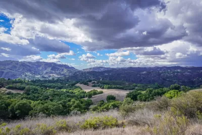
Topanga State Park is a California state park located in the Santa Monica Mountains and is part of the Santa Monica Mountains National Recreation Area. The park is located adjacent to the community of Topanga in the City of Los Angeles. With an area of 11,000 acres and 36 miles of trails and unimproved roads, the park's boundaries stretch from Topanga Canyon to Pacific Palisades and Mulholland Drive.
According to AllTrails, a popular fitness and travel mobile app, Topanga State Park has many highly-rated trails, most of which are of moderate difficulty and vary in length from three to seven miles. Many trails are accessible to hikers, mountain bikers, and horseback riders, and some also serve as fire roads. The primary trailheads are at the Trippet Ranch area passing Eagle Rock. The Backbone Trail System, a multi-use long-distance trail spanning almost 70 miles across the Santa Monica Mountains, passes through Topanga State Park. A few of the most popular trails at the park are:
- Temescal Canyon Trail
- Skull Rock Loop
- Los Leones Trail
- Los Leones Canyon Trail
- Paseo Miramar Trail
For more information, please read the source article. To find out more about trails across Los Angeles County, readers may also check out this website created and maintained by the L.A. County Department of Parks and Recreation.
FULL STORY: This State Park Is The Top Choice For Hikers In California


Advancing Park Equity Through Needs Assessments
City Parks Alliance, in partnership with Prevention Institute, recently hosted a webinar about park equity and collaboration, focusing on the Los Angeles Countywide Parks Needs Assessment.

Diverse Perspectives of America Outdoors
Best-selling writer, podcaster and comedian Baratunde Thurston travels the country to better understand and explain people's complex relationship with the outdoors in a series on PBS.

After the Fires: Challenges and Efforts to Heal LA’s Parks and Trails
The recent LA wildfires have devastated parks and trails, with recovery efforts requiring extended closures, collaborative restoration plans, and community support to address extensive damage and long-term risks like landslides.

Study: Maui’s Plan to Convert Vacation Rentals to Long-Term Housing Could Cause Nearly $1 Billion Economic Loss
The plan would reduce visitor accommodation by 25,% resulting in 1,900 jobs lost.

North Texas Transit Leaders Tout Benefits of TOD for Growing Region
At a summit focused on transit-oriented development, policymakers discussed how North Texas’ expanded light rail system can serve as a tool for economic growth.

Why Should We Subsidize Public Transportation?
Many public transit agencies face financial stress due to rising costs, declining fare revenue, and declining subsidies. Transit advocates must provide a strong business case for increasing public transit funding.

How to Make US Trains Faster
Changes to boarding platforms and a switch to electric trains could improve U.S. passenger rail service without the added cost of high-speed rail.

Columbia’s Revitalized ‘Loop’ Is a Hub for Local Entrepreneurs
A focus on small businesses is helping a commercial corridor in Columbia, Missouri thrive.

Invasive Insect Threatens Minnesota’s Ash Forests
The Emerald Ash Borer is a rapidly spreading invasive pest threatening Minnesota’s ash trees, and homeowners are encouraged to plant diverse replacement species, avoid moving ash firewood, and monitor for signs of infestation.
Urban Design for Planners 1: Software Tools
This six-course series explores essential urban design concepts using open source software and equips planners with the tools they need to participate fully in the urban design process.
Planning for Universal Design
Learn the tools for implementing Universal Design in planning regulations.
Ascent Environmental
Borough of Carlisle
Institute for Housing and Urban Development Studies (IHS)
City of Grandview
Harvard GSD Executive Education
Toledo-Lucas County Plan Commissions
Salt Lake City
NYU Wagner Graduate School of Public Service