


The interactive map details zoning rules along with local services like sanitation, transportation, and more.
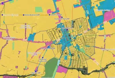
A new interactive ‘zoning atlas’ offers Long Island residents a way to understand the complex web of land use, municipal services, transportation, and zoning districts on the island. As Desiree D'Iorio explains in a piece for WSHU, “It can be filtered to show details like public transportation routes, downtown areas, current land use and special districts for services like sewers, schools, ambulances and sanitation.”
Gwen O'Shea, president of Community Development Long Island, said the tool can help governments and builders understand what type of housing is permitted where and how those regulations intersect with services like transit. “It can help developers see what building opportunities are available, and help officials and housing advocates understand how housing policies impact homeowners and communities.”
FULL STORY: New tool hopes to change how Long Island understands its complex zoning


Barriers to Integration Come Down Slowly in Wealthy, White Suburban Enclaves
Beware of possible code words like "character" and "flavor" when it comes to community resistance to multifamily housing or increased density. Case in point, Garden City, Long Island.

How Atlanta Built 7,000 Housing Units in 3 Years
The city’s comprehensive, neighborhood-focused housing strategy focuses on identifying properties and land that can be repurposed for housing and encouraging development in underserved neighborhoods.

San Antonio Remains Affordable as City Grows
The city’s active efforts to keep housing costs down through housing reforms and coordinated efforts among city agencies and developers have kept it one of the most affordable in the nation despite its rapid population growth.

Study: Maui’s Plan to Convert Vacation Rentals to Long-Term Housing Could Cause Nearly $1 Billion Economic Loss
The plan would reduce visitor accommodation by 25,% resulting in 1,900 jobs lost.

North Texas Transit Leaders Tout Benefits of TOD for Growing Region
At a summit focused on transit-oriented development, policymakers discussed how North Texas’ expanded light rail system can serve as a tool for economic growth.

Using Old Oil and Gas Wells for Green Energy Storage
Penn State researchers have found that repurposing abandoned oil and gas wells for geothermal-assisted compressed-air energy storage can boost efficiency, reduce environmental risks, and support clean energy and job transitions.

Private Donations Propel Early Restoration of Palisades Playground
Los Angeles has secured over $1.3 million in private funding to restore the Pacific Palisades playground months ahead of schedule, creating a modern, accessible space that supports community healing after recent wildfires.

From Blight to Benefit: Early Results From California’s Equitable Cleanup Program
The Equitable Community Revitalization Grant (ECRG) program is reshaping brownfield redevelopment by prioritizing projects in low-income and environmental justice communities, emphasizing equity, transparency, and community benefits.

Planting Relief: Tackling Las Vegas Heat One Tree at a Time
Nevada Plants, a Las Vegas-based nonprofit, is combating the city’s extreme urban heat by giving away trees to residents in underserved neighborhoods, promoting shade, sustainability, and community health.
Urban Design for Planners 1: Software Tools
This six-course series explores essential urban design concepts using open source software and equips planners with the tools they need to participate fully in the urban design process.
Planning for Universal Design
Learn the tools for implementing Universal Design in planning regulations.
Ascent Environmental
Borough of Carlisle
Institute for Housing and Urban Development Studies (IHS)
City of Grandview
Harvard GSD Executive Education
Toledo-Lucas County Plan Commissions
Salt Lake City
NYU Wagner Graduate School of Public Service