


Norwalk, Connecticut is figuring out how to balance the competing interests of development demand, public access, environmental risks, and historic preservation.
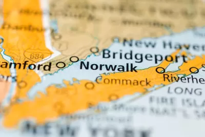
Norwalk, located in Fairfield County, Connecticut, is working on a new waterfront plan that balances the community’s long history and the contemporary risks of sea-level rise and climate change.
According to an article by Katherine Lutge, the city has been planning the future of the waterfront since 2021. Boston-based firm UTILE Architecture & Planning produced the "Norwalk Industrial Waterfront Land Use Study" earlier this year, and now several local organizations are concerned about zoning and other changes proposed by the report.
According to the city, the three primary goals of the plan are to increase public access to the waterfront, retain commercial and industrial water dependent uses, and address environmental concerns through development best practices.
“By proposing zoning that allows for mixed-use development that is water dependent, there is an opportunity to redevelop the sites closest to Washington Street, which may activate the waterfront area for public access. This could potentially include restaurants, boardwalks, boat slips and public open space,” according to a statement from the city quoted in the article.
Lutge also reports, however, that the Harbor Management Commission, Shellfish Commission, and Water Quality Commission are raising concerns about the possibility of new development density on the city’s waterfront, potentially in the 100-year floodplain.
More details about the proposed zoning changes, and the emerging opposition to those changes, are included in the source article below.
FULL STORY: Norwalk debates history, density and future of waterfront due to new plan, zoning rewrite

NYC Zoning Reform: Where Will It Have an Impact?
The zoning reform package dubbed ‘City of Yes’ will likely yield uneven results, with many of the lowest-density neighborhoods exempted from new regulations.

‘Grand Boulevards’ Could Ease Housing Crisis
A prominent urbanist argues that redeveloping commercial corridors with denser housing could bridge the gap between the housing supply and demand.
Boston Moves Zoning Reform Forward
The ‘Squares + Streets’ plan creates form-based zoning templates for neighborhoods that promote mixed use and denser housing near transit.

Alabama: Trump Terminates Settlements for Black Communities Harmed By Raw Sewage
Trump deemed the landmark civil rights agreement “illegal DEI and environmental justice policy.”

Study: Maui’s Plan to Convert Vacation Rentals to Long-Term Housing Could Cause Nearly $1 Billion Economic Loss
The plan would reduce visitor accommodation by 25% resulting in 1,900 jobs lost.

Planetizen Federal Action Tracker
A weekly monitor of how Trump’s orders and actions are impacting planners and planning in America.

Waymo Gets Permission to Map SF’s Market Street
If allowed to operate on the traffic-restricted street, Waymo’s autonomous taxis would have a leg up over ride-hailing competitors — and counter the city’s efforts to grow bike and pedestrian on the thoroughfare.

Parklet Symposium Highlights the Success of Shared Spaces
Parklets got a boost during the Covid-19 pandemic, when the concept was translated to outdoor dining programs that offered restaurants a lifeline during the shutdown.

Federal Homelessness Agency Places Entire Staff on Leave
The U.S. Interagency Council on Homelessness is the only federal agency dedicated to preventing and ending homelessness.
Urban Design for Planners 1: Software Tools
This six-course series explores essential urban design concepts using open source software and equips planners with the tools they need to participate fully in the urban design process.
Planning for Universal Design
Learn the tools for implementing Universal Design in planning regulations.
Caltrans
Smith Gee Studio
Institute for Housing and Urban Development Studies (IHS)
City of Grandview
Harvard GSD Executive Education
Toledo-Lucas County Plan Commissions
Salt Lake City
NYU Wagner Graduate School of Public Service