


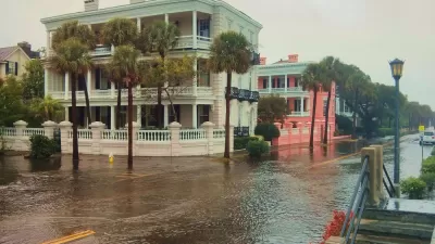
New research shows a 24% increase in people living in flood-prone areas since 2000, prompting calls for increased adaptation measures.

As urban centers around the world grow, sea levels rise, and extreme weather becomes more common, "the proportion of the world’s population living in flood zones has increased exponentially," writes Linda Poon. According to new research published in the journal Nature, "[f]rom 2000 to 2015, the number of people living in flood-prone areas increased by an estimated 58 million to 86 million," a 24% increase.
"The study uses a trove of satellite imagery to map 913 major flood events since 2000, which the flood monitoring startup Cloud to Street says offers planners a more detailed scope than flood projection models of the crisis facing cities." The resulting maps "combine flooding imagery with global human settlement data to show population growth in flooded areas, which the researchers attribute to increased economic development and migration to flood zones."
"Nearly 90% of the floods analyzed occurred in South and Southeast Asia, with high flood exposure in areas that have large river basins and that saw large population growth, like Dhaka and Bangladesh. In 32 countries across four continents, the population exposed to flood is increasing at a rate higher than total population growth, with India and some countries in Africa experiencing particularly large increases in flood exposure."
Flooding also poses a risk to basic infrastructure. "From the recent flooding of New York City’s nearly 120-year-old subway to Zhengzhou’s metro system in China’s Henan province, much of the urban infrastructure built decades ago is not designed to handle the kind of historic rainfall that cities often see today."
The researchers are making the database public "to help policymakers improve the accuracy of global flood risk models, which can be rife with uncertainties," and "improve the quality of vulnerability assessments, which in turn can increase the efficacy of climate adaptation measures."
FULL STORY: More People Live in Flood Zones Than Previously Thought

As Development in Flood-Prone Areas Continues, Cities Are Slow to Respond
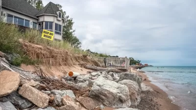
Drawn by affordable property, low taxes, and job opportunities, high numbers of Americans continue to move to flood-prone areas even as the threat of catastrophic flooding grows.

Rising Above: Innovative Solutions for Waikīkī’s Sea-Level Challenges
The University of Hawaiʻi at Mānoa’s award-winning Waikīkī sea-level rise adaptation project combines science, architecture, and community input to create scalable solutions for climate resilience and coastal flood mitigation.
How US Cities Can Prepare for Climate Disasters
Resilience, encompassing infrastructure, governance, economic strength, and social cohesion, is critical for cities to mitigate rising climate risks like flooding, wildfires, and heat, ensuring long-term recovery and adaptability.

Study: Maui’s Plan to Convert Vacation Rentals to Long-Term Housing Could Cause Nearly $1 Billion Economic Loss
The plan would reduce visitor accommodation by 25,% resulting in 1,900 jobs lost.

Alabama: Trump Terminates Settlements for Black Communities Harmed By Raw Sewage
Trump deemed the landmark civil rights agreement “illegal DEI and environmental justice policy.”

Why Should We Subsidize Public Transportation?
Many public transit agencies face financial stress due to rising costs, declining fare revenue, and declining subsidies. Transit advocates must provide a strong business case for increasing public transit funding.

Paris Bike Boom Leads to Steep Drop in Air Pollution
The French city’s air quality has improved dramatically in the past 20 years, coinciding with a growth in cycling.

Why Housing Costs More to Build in California Than in Texas
Hard costs like labor and materials combined with ‘soft’ costs such as permitting make building in the San Francisco Bay Area almost three times as costly as in Texas cities.

San Diego County Sees a Rise in Urban Coyotes
San Diego County experiences a rise in urban coyotes, as sightings become prevalent throughout its urban neighbourhoods and surrounding areas.
Urban Design for Planners 1: Software Tools
This six-course series explores essential urban design concepts using open source software and equips planners with the tools they need to participate fully in the urban design process.
Planning for Universal Design
Learn the tools for implementing Universal Design in planning regulations.
Smith Gee Studio
Alamo Area Metropolitan Planning Organization
City of Santa Clarita
Institute for Housing and Urban Development Studies (IHS)
City of Grandview
Harvard GSD Executive Education
Toledo-Lucas County Plan Commissions
Salt Lake City
NYU Wagner Graduate School of Public Service