


The Metropolitan Atlanta Rapid Transit Authority recently proposed ambitious station design concepts to supplement the Georgia Department of Transportation's plans for a 16-mile express bus lane system on Ga. Highway 400.
The Metropolitan Atlanta Rapid Transit Authority (MARTA) has revealed new station concepts for proposed express bus lanes on Ga. Highway 400 that would add five stops between Sandy Springs and Alpharetta.
Josh Green reports on the newly released station concepts for the project, cautioning that the bus station concepts still have a long way to go, and funding uncertainties to overcome, before coming to fruition.
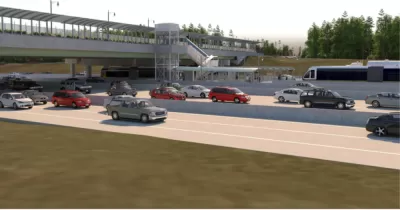
"In a perfect world for MARTA," however, "the Georgia Department of Transportation’s express lanes project on Ga. Highway 400 will open in about six years with efficient bus stops in the middle of highway lanes, dotted from Sandy Springs to the northern reaches of Alpharetta, offering transportation alternatives to thousands of commuters daily."
The bus station concepts are meant to supplement the work done by the Georgia Department of Transportation on the express lanes project. As Green explains, "MARTA’s broader goal is to take advantage of the billion-dollar investment GDOT is making to build about 16 miles of express lanes up Ga. Highway 400 as part of the agency’s Major Mobility Investment Program, which will also see express lanes installed on Interstate 285."
In all, "MARTA hopes to build five BRT stations, with stops at North Springs, Holcomb Bridge Road, North Point Mall, Old Milton Parkway, and Windward Parkway in Alpharetta, near Cumming. Total costs could exceed $176 million." MARTA is suggesting that a tax allocation district (TAD) or a special services district (the latter gaining a new example on the BeltLine earlier this month) to come up with the necessary funding to build the stations.
FULL STORY: Concepts emerge for MARTA's rapid bus system up Ga. Highway 400

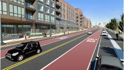
Atlanta Transit Officials Call for Traffic Cameras to Enforce Bus-Only Lanes
MARTA says bus-mounted cameras would be a more effective way to keep bus lanes clear and make upcoming bus rapid transit lines run smoothly and reliably.
BRT Stations Cut, Project Delayed in Atlanta
Inflation is taking a bite out of planned transportation projects in Georgia. The state's first ever bus rapid transit project provides the latest example of scaled back ambitions.

Light Rail Plans Could Become Bus Rapid Transit Plans in Atlanta
Light rail on the Clifton Corridor was once a centerpiece of a $2.7 billion, 40-year transit expansion plans funded by a voter-approved sales tax. Now MARTA is considering using bus rapid transit on the corridor instead.

Alabama: Trump Terminates Settlements for Black Communities Harmed By Raw Sewage
Trump deemed the landmark civil rights agreement “illegal DEI and environmental justice policy.”

Study: Maui’s Plan to Convert Vacation Rentals to Long-Term Housing Could Cause Nearly $1 Billion Economic Loss
The plan would reduce visitor accommodation by 25% resulting in 1,900 jobs lost.

Planetizen Federal Action Tracker
A weekly monitor of how Trump’s orders and actions are impacting planners and planning in America.

Waymo Gets Permission to Map SF’s Market Street
If allowed to operate on the traffic-restricted street, Waymo’s autonomous taxis would have a leg up over ride-hailing competitors — and counter the city’s efforts to grow bike and pedestrian on the thoroughfare.

Parklet Symposium Highlights the Success of Shared Spaces
Parklets got a boost during the Covid-19 pandemic, when the concept was translated to outdoor dining programs that offered restaurants a lifeline during the shutdown.

Federal Homelessness Agency Places Entire Staff on Leave
The U.S. Interagency Council on Homelessness is the only federal agency dedicated to preventing and ending homelessness.
Urban Design for Planners 1: Software Tools
This six-course series explores essential urban design concepts using open source software and equips planners with the tools they need to participate fully in the urban design process.
Planning for Universal Design
Learn the tools for implementing Universal Design in planning regulations.
Caltrans
Smith Gee Studio
Institute for Housing and Urban Development Studies (IHS)
City of Grandview
Harvard GSD Executive Education
Toledo-Lucas County Plan Commissions
Salt Lake City
NYU Wagner Graduate School of Public Service