


The massive River Ring Waterfront Master Plan includes two towers containing 1,050 residential units, a three-acre beach, and 5,000 square feet of community kiosks.
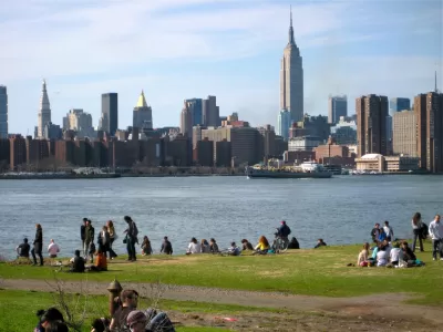
After pandemic-related delays, the developer of a massive project on the Brooklyn waterfront, the River Ring Waterfront Master Plan, is making efforts to get construction back on track, with a few changes. As reported by Diane Pham in Urbanize New York, the revised plan increases the height of the towers by 60 feet each and changes the buildings' facades to "a mix of glass, steel and concrete versus a combo of glass and a terracotta-colored cladding."
The buildings will now accommodate 50 more housing units than previously planned for a total of 1,050, of which "around 25 percent, or 263 units, will be made permanently affordable at 40 and 60 percent AMI." The project also includes a three-acre sandy beach surrounded by a circular esplanade, as well as "tidal pools, a salt marsh, nature trails, a wetland walk, overlooks, seating and picnic areas, a boating cove on North 1st Street, an amphitheater, and 5,000 square feet reserved for community kiosks" for a total of more than six acres of new public space. The plan also calls for the installation of breakwaters to mitigate potential flooding, and "per the River Ring website, the development will be supported by its own microgrid energy system, mitigating demand on the Con Edison system and offloading excess power to neighboring facilities and buildings."
Scheduled to complete construction in seven years, "the development is expected to generate approximately 2,000 construction jobs and more than 500 'well-paying' permanent jobs including building service workers, park employees, YMCA and community facility employees, and retail employees." Local residents have had mixed reactions, with many expressing support for the new park but alarm at "the scale of the towers and the effect so many new residents and waterfront patrons might have on local infrastructure and the economy."
FULL STORY: New look for Two Trees' epic River Ring Waterfront Master Plan in Williamsburg

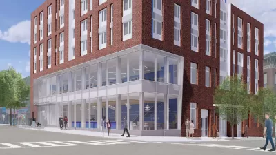
Brooklyn Library Comes With Affordable Housing
Combining affordable housing with a library reduced the cost of the project and gives residents access to essential resources.
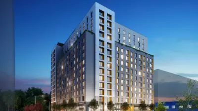
‘Passive House’ Development Brings 275 Affordable, Efficient Units to Brooklyn
A 14-story tower uses the ‘Passive House’ approach to drastically reduce energy use and improve quality of life for residents.
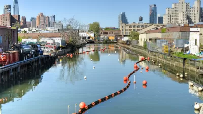
Gowanus Racial Impact Study Predicts Increased Diversity After Rezoning
The report outlines the potential impacts on the neighborhood's racial diversity and the availability of below-market housing units.

Alabama: Trump Terminates Settlements for Black Communities Harmed By Raw Sewage
Trump deemed the landmark civil rights agreement “illegal DEI and environmental justice policy.”

Study: Maui’s Plan to Convert Vacation Rentals to Long-Term Housing Could Cause Nearly $1 Billion Economic Loss
The plan would reduce visitor accommodation by 25% resulting in 1,900 jobs lost.

Planetizen Federal Action Tracker
A weekly monitor of how Trump’s orders and actions are impacting planners and planning in America.

Waymo Gets Permission to Map SF’s Market Street
If allowed to operate on the traffic-restricted street, Waymo’s autonomous taxis would have a leg up over ride-hailing competitors — and counter the city’s efforts to grow bike and pedestrian on the thoroughfare.

Parklet Symposium Highlights the Success of Shared Spaces
Parklets got a boost during the Covid-19 pandemic, when the concept was translated to outdoor dining programs that offered restaurants a lifeline during the shutdown.

Federal Homelessness Agency Places Entire Staff on Leave
The U.S. Interagency Council on Homelessness is the only federal agency dedicated to preventing and ending homelessness.
Urban Design for Planners 1: Software Tools
This six-course series explores essential urban design concepts using open source software and equips planners with the tools they need to participate fully in the urban design process.
Planning for Universal Design
Learn the tools for implementing Universal Design in planning regulations.
Caltrans
Smith Gee Studio
Institute for Housing and Urban Development Studies (IHS)
City of Grandview
Harvard GSD Executive Education
Toledo-Lucas County Plan Commissions
Salt Lake City
NYU Wagner Graduate School of Public Service