


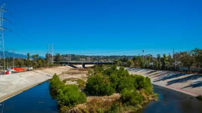
A new draft Los Angeles Master Plan, created by Frank Gehry's firm, lays out a more active, natural vision for the river, in addition to addressing concerns about displacement in communities along the river corridor.

Los Angeles County this week released a draft update to the Los Angeles River Master Plan.
Steven Sharp reports on the document, which is "intended to guide the development of new parks and water quality projects along the 51-mile corridor, while also accounting for potential displacement and equity issues in neighboring communities."
The Los Angeles River was infamously encased in concrete after a series of destructive storms in the early 20th century, but, as Sharp notes, "sparse rainfall in Southern California mean's that the river is only needed for its flood control functions roughly 2 percent of the time [.....] That creates an opportunity for recreational activities and public open space on much of the corridor."
Sharp summarizes some of the plan's approach to development potential along the river thusly:
Although the master plan does not effectuate any specific investments along the river, the document identifies 56 potential projects between the San Fernando Valley and the South Bay. In addition to building off of existing proposals - such as a 42-acre park at the Taylor Yard or the Downtown leg of the L.A. River bike path - the plan includes a "kit of parts" outlining an array of improvements to the channel, ranging from more modest river trails to channel modifications and even flood plain reclamation.
The county hired architect Frank Gehry's firm, working with landscape architect Laurie Olin, to complete the master plan. An article by Louis Sahagún for the Los Angeles Times devotes more ink to the starchitect angle inherent to the release of the draft master plan. Olin's contribution to the plan, according to Sharp, is a vision for "100 miles of public trails along the river, as well as park projects that restore habitats and improve water quality."
Gehry's role on the Los Angeles River has been controversial in the past. Gehry's firm was working in the background without public attention early in the process, but Gehry's initial work focused on hydrology, so the scope of the planning work has clearly expanded since then. At the time, concerns included a lack of understanding about how Gehry's work fit in with the Los Angeles River Revitalization Mater Plan, approved in 2007, and a plan released in 2013 by the U.S. Army Corps of Engineers that shifted the focus of planning and engineering along the river to include habitat restoration in addition to stormwater protection.
FULL STORY: Here's a Look at the Updated L.A. River Master Plan


Los Angeles County: It's Time to Update the Master Plan for the L.A. River
The Los Angeles County Board of Supervisors voted this week to begin the processing of updating the 20-year-old Los Angeles River Master Plan.
A Comment for the L.A. River Master Plan
Five themes proposed to achieve justice and sustainability for the Los Angeles River and its surrounding communities.

Gehry's Plans for Los Angeles River Restoration Gaining Clarity
Details are emerging in the controversial effort by Gehry Partners, LLP to plan a new vision for the Los Angeles River. So far, however, Gehry Partners seems to have been listening more than plotting or drawing.

Study: Maui’s Plan to Convert Vacation Rentals to Long-Term Housing Could Cause Nearly $1 Billion Economic Loss
The plan would reduce visitor accommodation by 25,% resulting in 1,900 jobs lost.

North Texas Transit Leaders Tout Benefits of TOD for Growing Region
At a summit focused on transit-oriented development, policymakers discussed how North Texas’ expanded light rail system can serve as a tool for economic growth.

Why Should We Subsidize Public Transportation?
Many public transit agencies face financial stress due to rising costs, declining fare revenue, and declining subsidies. Transit advocates must provide a strong business case for increasing public transit funding.

How to Make US Trains Faster
Changes to boarding platforms and a switch to electric trains could improve U.S. passenger rail service without the added cost of high-speed rail.

Columbia’s Revitalized ‘Loop’ Is a Hub for Local Entrepreneurs
A focus on small businesses is helping a commercial corridor in Columbia, Missouri thrive.

Invasive Insect Threatens Minnesota’s Ash Forests
The Emerald Ash Borer is a rapidly spreading invasive pest threatening Minnesota’s ash trees, and homeowners are encouraged to plant diverse replacement species, avoid moving ash firewood, and monitor for signs of infestation.
Urban Design for Planners 1: Software Tools
This six-course series explores essential urban design concepts using open source software and equips planners with the tools they need to participate fully in the urban design process.
Planning for Universal Design
Learn the tools for implementing Universal Design in planning regulations.
City of Santa Clarita
Ascent Environmental
Institute for Housing and Urban Development Studies (IHS)
City of Grandview
Harvard GSD Executive Education
Toledo-Lucas County Plan Commissions
Salt Lake City
NYU Wagner Graduate School of Public Service