


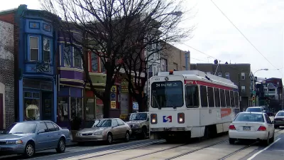
A report from the Brookings Institution shows how planners can use new types of anonymized data to inform mobility planning decisions.

A recently published Brookings Institution report, titled "Connecting people and places: Exploring new measures of travel behavior," uses data derived from geolocation sources to analyze information about patterns of travel in six U.S. metropolitan areas.
Thanks to such sources as cell phone data and shared bike platforms, planners now have access to data that could be used to shed light on mobility, reports Bill Lucia. The researchers responsible for the Brookings report assert that the use of this data in planning practice is not only beneficial on the individual level, but also to society at large.
Lucia writes:
The ideas raised in the report tie back to longstanding, and sometimes contentious, policy issues in areas like housing affordability, racial and income inequality, transit, and the legacy of how America has built and reworked cities and suburbs over decades of time.
But the way the researchers tap into the geolocation data to provide a foundation for their analysis underscores how state and local agencies might use this type of information in similar ways to inform policy decisions and discussions surrounding these issues.
The data used in the report was collected and anonymized by the company Replica. Researchers at the Brookings Institution's Metropolitan Policy Program fellow Adie Tomer is quoted in the article saying that the research reveals the power of location data to inform new choices for mobility planning.
FULL STORY: Geolocation Data Could Help Planners Design Communities that Require Less Driving


A Compact, Connected, Clean, and Inclusive Recovery for Mexico
As the Mexican government charts the country’s recovery from COVID-19, a newly published paper charts national solutions to urban transportation and housing challenges that will put Mexico’s cities on a path to prosperity and resilience.

Austin Strategic Mobility Plan Final Draft Released
The first priority of the draft Austin Strategic Mobility Plan is to reduce single-occupant vehicle trips.
Philadelphia's First Strategic Transportation Plan Released
Getting serious about mobility and traffic safety in the City of Brotherly Love.

Study: Maui’s Plan to Convert Vacation Rentals to Long-Term Housing Could Cause Nearly $1 Billion Economic Loss
The plan would reduce visitor accommodation by 25,% resulting in 1,900 jobs lost.

North Texas Transit Leaders Tout Benefits of TOD for Growing Region
At a summit focused on transit-oriented development, policymakers discussed how North Texas’ expanded light rail system can serve as a tool for economic growth.

Using Old Oil and Gas Wells for Green Energy Storage
Penn State researchers have found that repurposing abandoned oil and gas wells for geothermal-assisted compressed-air energy storage can boost efficiency, reduce environmental risks, and support clean energy and job transitions.

Santa Barbara Could Build Housing on County Land
County supervisors moved forward a proposal to build workforce housing on two county-owned parcels.

San Mateo Formally Opposes Freeway Project
The city council will send a letter to Caltrans urging the agency to reconsider a plan to expand the 101 through the city of San Mateo.

A Bronx Community Fights to Have its Voice Heard
After organizing and giving input for decades, the community around the Kingsbridge Armory might actually see it redeveloped — and they want to continue to have a say in how it goes.
Urban Design for Planners 1: Software Tools
This six-course series explores essential urban design concepts using open source software and equips planners with the tools they need to participate fully in the urban design process.
Planning for Universal Design
Learn the tools for implementing Universal Design in planning regulations.
Ascent Environmental
Borough of Carlisle
Institute for Housing and Urban Development Studies (IHS)
City of Grandview
Harvard GSD Executive Education
Toledo-Lucas County Plan Commissions
Salt Lake City
NYU Wagner Graduate School of Public Service