


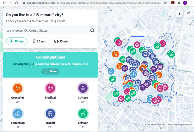
The new 15-Minute City App generates maps which show the number of services and activities within a 15 minute walk, and and therefore whether an area can be considered a 15-minute neighborhood.

A 15-min city, or “la ville du quart d’heure” refers to an urban neighborhood where all the essential needs can be accessed within a 15 minute walk or bike ride. This is a practical way to evaluate multi-modal accessibility, that is, the ease of living without a car, and therefore whether a neighborhood is affordable, equitable, healthy and resource-efficient.
The new 15-Minute City App generates maps for U.S. addresses which show the number of medical centers, grocery stores, cultural attractions, transit stops, education facilities and leisure spots that can be reached within a 15 or 20 minute walk, and therefore whether it can be considered to be in a 15-minute neighborhood.
Real estate agents and developers pay attention: consumer preference surveys indicate that most households want to live in walkable neighborhoods, resulting in a shortage of such housing. Let's build lots more!
FULL STORY: Do you live in a “15-minute” city?


Analyzing Accessibility Disparities
With better planning we can reduce disparities between drivers and non-drivers in their ability to access services and jobs, improving fairness and economic opportunities for disadvantaged groups.

Commentary: Avoiding Ableism in 15-Minute Cities
One author calls on planners to challenge assumptions that exclude people with mobility challenges and other disabilities.

What the ‘Walk Score’ Misses
A popular walkability assessment omits key factors that impact different demographics and can direct development resources to already wealthy neighborhoods.

Alabama: Trump Terminates Settlements for Black Communities Harmed By Raw Sewage
Trump deemed the landmark civil rights agreement “illegal DEI and environmental justice policy.”

Study: Maui’s Plan to Convert Vacation Rentals to Long-Term Housing Could Cause Nearly $1 Billion Economic Loss
The plan would reduce visitor accommodation by 25% resulting in 1,900 jobs lost.

Planetizen Federal Action Tracker
A weekly monitor of how Trump’s orders and actions are impacting planners and planning in America.

Wind Energy on the Rise Despite Federal Policy Reversal
The Trump administration is revoking federal support for renewable energy, but demand for new projects continues unabated.

Passengers Flock to Caltrain After Electrification
The new electric trains are running faster and more reliably, leading to strong ridership growth on the Bay Area rail system.

Texas Churches Rally Behind ‘Yes in God’s Back Yard’ Legislation
Religious leaders want the state to reduce zoning regulations to streamline leasing church-owned land to housing developers.
Urban Design for Planners 1: Software Tools
This six-course series explores essential urban design concepts using open source software and equips planners with the tools they need to participate fully in the urban design process.
Planning for Universal Design
Learn the tools for implementing Universal Design in planning regulations.
Caltrans
Smith Gee Studio
Institute for Housing and Urban Development Studies (IHS)
City of Grandview
Harvard GSD Executive Education
Toledo-Lucas County Plan Commissions
Salt Lake City
NYU Wagner Graduate School of Public Service