


The regions of the United States that have provided the most hospitable to human life and agriculture on the continent will likely be abandoned in a future altered by climate change, according to this interactive mapping project.
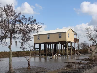
Al Shaw, Abrahm Lustgarten, and Jeremy W. Goldsmith crunch data from a number of recent sources to map out the future of the United States as altered by climate change. "[T]he North American places where humans have lived for thousands of years will shift," according to the authors of the article to introduce the interactive map found at the source link.
The project uses data from a paper published in the Proceedings of the National Academy of Sciences that maps out the shifting future of the human climate "niche," described here at "the regions where temperature and precipitation have been most suitable for humans to live in over the past 6,000 years."
As a result of climate change, "the niche could shift drastically northward. Under even a moderate carbon emissions scenario (known as RCP 4.5), by 2070 much of the Southeast becomes less suitable and the niche shifts toward the Midwest."
Additional research by the Rhodium Group supplies the map's focus on rising temperatures in much of the United States. But there's a catch: "Heat alone, however, won’t determine Americans’ fate. A new climate analysis — presented for the first time here — projects how humidity and heat will collide to form 'wet bulb' temperatures that will disrupt the norms of daily existence."
The outcomes predicted here—including additional factors like sea-level rise, large wildfires, crop yields that will create a cascade of compounding calamities—are nothing short of catastrophic: "profound economic loss" and mass migration in the United States.
Another article by Abrahm Lustgarten supplements the mapping project by exploring in detail the likelihood of a climate migration in the United States within this century. A climate migration is a familiar theme in the news in recent weeks, as fires rage throughout the west and hurricanes stack up in the Atlanta Ocean and Gulf of Mexico.
FULL STORY: New Climate Maps Show a Transformed United States


1.2 Million Climate Refugees and Counting in the United States
Americans are fleeing the effects of climate change by the millions. Expect the number of climate refugees to continue to grow.
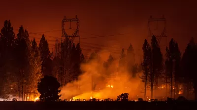
Intense October Heat Wave Raises Fire Risk in California
Unusually high temperatures across the state are prompting power shutoffs and could fuel more destructive wildfires.

California Faces Early Surge in Wildfires
Summer is just beginning, but wildfires in California have already burned more than 90,000 acres.

Alabama: Trump Terminates Settlements for Black Communities Harmed By Raw Sewage
Trump deemed the landmark civil rights agreement “illegal DEI and environmental justice policy.”

Study: Maui’s Plan to Convert Vacation Rentals to Long-Term Housing Could Cause Nearly $1 Billion Economic Loss
The plan would reduce visitor accommodation by 25% resulting in 1,900 jobs lost.

Why Should We Subsidize Public Transportation?
Many public transit agencies face financial stress due to rising costs, declining fare revenue, and declining subsidies. Transit advocates must provide a strong business case for increasing public transit funding.

Paris Bike Boom Leads to Steep Drop in Air Pollution
The French city’s air quality has improved dramatically in the past 20 years, coinciding with a growth in cycling.

Why Housing Costs More to Build in California Than in Texas
Hard costs like labor and materials combined with ‘soft’ costs such as permitting make building in the San Francisco Bay Area almost three times as costly as in Texas cities.

San Diego County Sees a Rise in Urban Coyotes
San Diego County experiences a rise in urban coyotes, as sightings become prevalent throughout its urban neighbourhoods and surrounding areas.
Urban Design for Planners 1: Software Tools
This six-course series explores essential urban design concepts using open source software and equips planners with the tools they need to participate fully in the urban design process.
Planning for Universal Design
Learn the tools for implementing Universal Design in planning regulations.
Smith Gee Studio
Alamo Area Metropolitan Planning Organization
City of Santa Clarita
Institute for Housing and Urban Development Studies (IHS)
City of Grandview
Harvard GSD Executive Education
Toledo-Lucas County Plan Commissions
Salt Lake City
NYU Wagner Graduate School of Public Service