


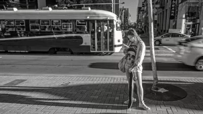
In case you've ever felt like Google Maps isn't as helpful on foot as it is in a car, there's a new technology just for you.

David Nield shares a preview of Google's new Visual Position System (VPS), which uses a variety of augmented reality to help guide pedestrians around the city:
The perfect scenario for Google’s new Visual Position System, or VPS, is one you’ve probably been in already: Emerging from a subway station in a strange city. You’ve got your route planned out on your phone, but you don’t know which way is which, or the names of the roads—if you set off in the wrong direction initially, you can lose a lot of time retracing your steps.
And:
It’s designed to overcome the limitations of GPS in heavily built-up areas and remove confusion when you’re following walking directions. It’s not publicly available yet, but we’ve been able to try it, and here’s what’s coming.
Like any good navigator, the VPS locates the user by using clues from surrounding landmarks, The result is better directions:
VPS pulls its data from the buildings and landmarks around you rather than relying on satellite location alone. By combining VPS with Street View data and some machine learning, Google Maps can work out where you are (and where you should be headed) even if your GPS lock has you placed three blocks north.
Nield provides more explanation and a few helpful images to better illustrate how the technology works.
FULL STORY: I Tried Google Maps' Experimental Walking Directions of the Future

Multi-Modal Directions, Now Available on Google Maps
Under the transit tab on Google Maps, users will now be able to incorporate trips that start on a bike but end on a bus, train, or other mode of transport.
'OK Google, How Crowded is the Number 8 Bus?'
Google Maps will now share data about how crowded buses and trains are likely to be.

Google Inks Nuclear Power Deal
Tech giants are seeking out renewable energy to fuel power-hungry data centers and AI applications.

Alabama: Trump Terminates Settlements for Black Communities Harmed By Raw Sewage
Trump deemed the landmark civil rights agreement “illegal DEI and environmental justice policy.”

Planetizen Federal Action Tracker
A weekly monitor of how Trump’s orders and actions are impacting planners and planning in America.

Why Should We Subsidize Public Transportation?
Many public transit agencies face financial stress due to rising costs, declining fare revenue, and declining subsidies. Transit advocates must provide a strong business case for increasing public transit funding.

Understanding Road Diets
An explainer from Momentum highlights the advantages of reducing vehicle lanes in favor of more bike, transit, and pedestrian infrastructure.

New California Law Regulates Warehouse Pollution
A new law tightens building and emissions regulations for large distribution warehouses to mitigate air pollution and traffic in surrounding communities.

Phoenix Announces Opening Date for Light Rail Extension
The South Central extension will connect South Phoenix to downtown and other major hubs starting on June 7.
Urban Design for Planners 1: Software Tools
This six-course series explores essential urban design concepts using open source software and equips planners with the tools they need to participate fully in the urban design process.
Planning for Universal Design
Learn the tools for implementing Universal Design in planning regulations.
Caltrans
Smith Gee Studio
Institute for Housing and Urban Development Studies (IHS)
City of Grandview
Harvard GSD Executive Education
Toledo-Lucas County Plan Commissions
Salt Lake City
NYU Wagner Graduate School of Public Service