


A Washington Post feature analyzes the changing skylines of cities from the Rocky Mountains to the Pacific Ocean.
Scott Wilson provides the copy and Aaron Steckelberg provides the infographics in a must-read feature planners and urbanists all around the country, but especially in the Western United Stats.
"From the Rockies to the Pacific, cities are seeking to accommodate increasing populations amid housing shortages by growing up instead of out," writes Wilson. "A number of them, including this mile-high city hard against the Front Range, are considering projects that would construct some of the tallest buildings in the West."
According to Wilson, the recent development of taller, centrally located buildings reverses course for these cities, which have sprawled outward, rather than reaching upward, for decades.
"The towers are the showpieces, but across these urban centers, which have sprawled into suburbs for years, new housing and office projects also are being built taller than ever before. The construction is focused around public transportation centers, and, in some cases, cities are allowing heights to rise beyond original zoning rules as a reward for builders who contribute more to affordable housing."
It's a familiar narrative for Planetizen readers—the "return to the city" movement driving the revitalization and redevelopment of once-abandoned urban cores around the country. The new trick with this article is found in the graphics that showcase the buildings redefining height in the cities like Denver (the planned tallest building, 650 17th Street would reach 1,000 feet, far above the current tallest building, Republic Plaza, which reaches 714 feet). Graphics for Seattle, Long Beach, and Sacramento, along with passages of analysis into the land use and zoning changes driving new building heights, are also included in the article.
FULL STORY: The rising Western skyline

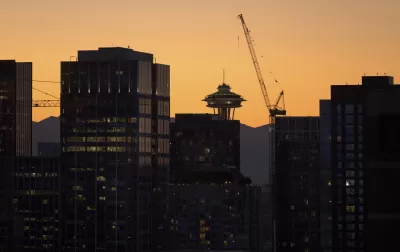
Zoning Changes Bring Good and Bad in Downtown Seattle
Zoning changes in downtown Seattle have created a more dense area, as was intended. But the zoning changes are also bringing some unintended consequences.
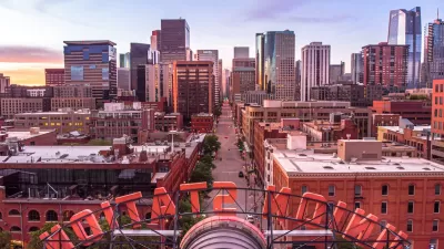
Denver Voters Approve Downtown Revitalization Bonds
The city wants to bring new projects and residents to the downtown core, where 13 million feet of vacant office and retail space await new tenants.
Denver Bans Downtown Food Trucks — Again
City officials say the controversial policy, first enacted in 2022, is an effort to reduce crime in the nightlife district.

Alabama: Trump Terminates Settlements for Black Communities Harmed By Raw Sewage
Trump deemed the landmark civil rights agreement “illegal DEI and environmental justice policy.”

Planetizen Federal Action Tracker
A weekly monitor of how Trump’s orders and actions are impacting planners and planning in America.

Why Should We Subsidize Public Transportation?
Many public transit agencies face financial stress due to rising costs, declining fare revenue, and declining subsidies. Transit advocates must provide a strong business case for increasing public transit funding.

Understanding Road Diets
An explainer from Momentum highlights the advantages of reducing vehicle lanes in favor of more bike, transit, and pedestrian infrastructure.

New California Law Regulates Warehouse Pollution
A new law tightens building and emissions regulations for large distribution warehouses to mitigate air pollution and traffic in surrounding communities.

Phoenix Announces Opening Date for Light Rail Extension
The South Central extension will connect South Phoenix to downtown and other major hubs starting on June 7.
Urban Design for Planners 1: Software Tools
This six-course series explores essential urban design concepts using open source software and equips planners with the tools they need to participate fully in the urban design process.
Planning for Universal Design
Learn the tools for implementing Universal Design in planning regulations.
Caltrans
Smith Gee Studio
Institute for Housing and Urban Development Studies (IHS)
City of Grandview
Harvard GSD Executive Education
Toledo-Lucas County Plan Commissions
Salt Lake City
NYU Wagner Graduate School of Public Service