


Data visualizations illustrate the catastrophic consequences of single-digit global temperature increases.

Emily Cassidy presents a series of dynamic maps showing the effects of climate change on five especially vulnerable cities around the world. “Using Climate Central data hosted on Resource Watch, we can explore areas likely to be flooded by 0.5 and 1.5 meters of sea level rise,” writes Cassidy.
The cities include New Orleans and New York; Guangzhou, China; Mumbia, India; and Osaka, Japan. Each city faces its own challenges and threats. For example, Guangzhou and Osaka are big port cities and Mumbai, with 12 million people, is the most populous city in India.
Cassidy says that these maps show how potentially devastating rises in sea level will be for major cities:
It’s clear from these maps that every foot of sea level rise matters. The next few years are crucial for avoiding catastrophic damage. The good news is we have the tools we need to make far-reaching changes to how we power our homes and businesses, grow our food and design our cities.
Resource Watch also provides a platform for users to create maps related to a number of other climate change effects.
FULL STORY: 5 Major Cities Threatened by Climate Change and Sea Level Rise

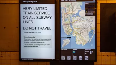
Ida Takes a Deadly Toll in the Northeast
Hurricane Ida passed through New Orleans, knocking out power causing extensive damage along the Gulf Coast. Then it moved to the Northeast, killing dozens of people with flooding caused by heavy rains.
As Sea Levels Rise, Some Cities Will Be Saved While Others Will Be Left Behind
U.S. coastal cities need to prepare for the effects of climate change, but the pot of funding is limited. There’s no way around the fact that there will be winners and there will be losers.

Boston’s Seaport District, Where Building Started Before Flood Preparation
The Boston waterfront has been booming, but the area is extremely vulnerable to climate change and rising sea levels. Measures to address those risks have come just recently.

Study: Maui’s Plan to Convert Vacation Rentals to Long-Term Housing Could Cause Nearly $1 Billion Economic Loss
The plan would reduce visitor accommodation by 25,% resulting in 1,900 jobs lost.

North Texas Transit Leaders Tout Benefits of TOD for Growing Region
At a summit focused on transit-oriented development, policymakers discussed how North Texas’ expanded light rail system can serve as a tool for economic growth.

Using Old Oil and Gas Wells for Green Energy Storage
Penn State researchers have found that repurposing abandoned oil and gas wells for geothermal-assisted compressed-air energy storage can boost efficiency, reduce environmental risks, and support clean energy and job transitions.

Santa Barbara Could Build Housing on County Land
County supervisors moved forward a proposal to build workforce housing on two county-owned parcels.

San Mateo Formally Opposes Freeway Project
The city council will send a letter to Caltrans urging the agency to reconsider a plan to expand the 101 through the city of San Mateo.

A Bronx Community Fights to Have its Voice Heard
After organizing and giving input for decades, the community around the Kingsbridge Armory might actually see it redeveloped — and they want to continue to have a say in how it goes.
Urban Design for Planners 1: Software Tools
This six-course series explores essential urban design concepts using open source software and equips planners with the tools they need to participate fully in the urban design process.
Planning for Universal Design
Learn the tools for implementing Universal Design in planning regulations.
Ascent Environmental
Borough of Carlisle
Caltrans
Institute for Housing and Urban Development Studies (IHS)
City of Grandview
Harvard GSD Executive Education
Toledo-Lucas County Plan Commissions
Salt Lake City
NYU Wagner Graduate School of Public Service