


An intrepid mapmaker has created a stunning map of the Pacific Electric Railway System, the old public transit system for L.A. and surrounding environs, once the largest trolley system in the world.

Erick Galindo shares the work of Jake Berman, who recently posted a map of the historic Los Angeles streetcar network on Reddit. Berman is quoted directly in the article explaining the thinking behind the map:
"I’d like Angelenos to be able to imagine a Los Angeles that wasn’t totally dependent on the car," Berman told L.A. Taco. "Contrary to popular belief, it was the streetcars that originally defined L.A. and you can still see traces of that legacy across the metropolis if you know where to look."
Berman has created a lot more maps, if visualizing a publicly oriented version of Los Angeles isn't enough. Berman's map work on his site fifty-three studio includes historical maps of Caracas, Venezuela and Oakland as well as the light rail system in Wakanda from Black Panther.
FULL STORY: THE GLORY DAYS OF L.A. PUBLIC TRANSIT IN 1926, MAPPED

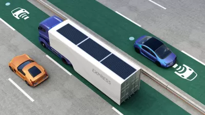
UCLA Will Build California’s First EV Charging Roadway
The ¾-mile segment will allow electric shuttles and buses to charge while driving.

LA’s ‘Car-Free’ Olympic Dream Is in Danger
Can the city fund its ambitious plans to build over $3 billion of public transit and sustainable transportation projects before the 2028 Olympic Games?
Opinion: LA Should Reject ‘Misguided’ Car-Centric Policies
Even as the city highlights clean energy and transportation for the 2028 Olympics, Metro and Caltrans move forward with plans to expand highways.

Alabama: Trump Terminates Settlements for Black Communities Harmed By Raw Sewage
Trump deemed the landmark civil rights agreement “illegal DEI and environmental justice policy.”

Planetizen Federal Action Tracker
A weekly monitor of how Trump’s orders and actions are impacting planners and planning in America.

Why Should We Subsidize Public Transportation?
Many public transit agencies face financial stress due to rising costs, declining fare revenue, and declining subsidies. Transit advocates must provide a strong business case for increasing public transit funding.

Understanding Road Diets
An explainer from Momentum highlights the advantages of reducing vehicle lanes in favor of more bike, transit, and pedestrian infrastructure.

New California Law Regulates Warehouse Pollution
A new law tightens building and emissions regulations for large distribution warehouses to mitigate air pollution and traffic in surrounding communities.

Phoenix Announces Opening Date for Light Rail Extension
The South Central extension will connect South Phoenix to downtown and other major hubs starting on June 7.
Urban Design for Planners 1: Software Tools
This six-course series explores essential urban design concepts using open source software and equips planners with the tools they need to participate fully in the urban design process.
Planning for Universal Design
Learn the tools for implementing Universal Design in planning regulations.
Caltrans
Smith Gee Studio
Institute for Housing and Urban Development Studies (IHS)
City of Grandview
Harvard GSD Executive Education
Toledo-Lucas County Plan Commissions
Salt Lake City
NYU Wagner Graduate School of Public Service