


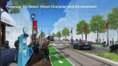
The city of Milwaukee has renderings to illustrate its ambitions for transit oriented development surrounding the streetcar extension into Bronzeville and Walker's Point.

"The City of Milwaukee has released conceptual renderings of how extending the streetcar system to Bronzeville and Walker’s Point could change both neighborhoods," reports Jermey Jannene.
The renderings, released to the public at a recent public hearing, depict streets with a full suite of complete street and traffic calming infrastructure. Jannene summarizes the depictions:
In Walker’s Point, the renderings depict empty lots on a traffic-calmed S. 1st St. being developed into mid-rise buildings and continued activation of S. 2nd St. following the street’s 2010 narrowing. A greenway, a street that encourages cycling over high-speed driving, is proposed for Washington St. that would better connect Walker’s Point and the Harbor District to neighborhoods to the west for cyclists. A similar proposal, sometimes called a bike boulevard, is in the works for Riverwest.
A rendering for Bronzeville depicts N. Martin Luther King Jr. Dr. receiving new development in context with existing buildings on the street. Traffic calming, green-painted bike lanes and medians are all depicted.
Click through to see the full set of renderings and also check out websites for the city's ongoing planning efforts regarding King Drive and the neighborhoods of Bronzeville and Walker's Point as well as the Milwaukee Streetcar.
FULL STORY: Renderings for Streetcar Extensions

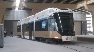
'The Hop' Streetcar Opens to the Public Today in Milwaukee
The Hop will deliver new transit service on the east side of downtown Milwaukee. The Hop comes also serves big development expectations from local officials.
Land Use Planning Precedes Streetcar Extension in Milwaukee
Plans to extend Milwaukee's The Hop streetcar line are still years away from fruition, but the city is already at work on development plans to make the most of the opportunity.

Why Free Rides on the Milwaukee 'Hop' Streetcar Are a Bad Idea
Citing the psychological impact of doughnuts and the American Red Cross, one opinion writer questions the wisdom of a recent sponsorship deal.

Alabama: Trump Terminates Settlements for Black Communities Harmed By Raw Sewage
Trump deemed the landmark civil rights agreement “illegal DEI and environmental justice policy.”

Study: Maui’s Plan to Convert Vacation Rentals to Long-Term Housing Could Cause Nearly $1 Billion Economic Loss
The plan would reduce visitor accommodation by 25% resulting in 1,900 jobs lost.

Planetizen Federal Action Tracker
A weekly monitor of how Trump’s orders and actions are impacting planners and planning in America.

Waymo Gets Permission to Map SF’s Market Street
If allowed to operate on the traffic-restricted street, Waymo’s autonomous taxis would have a leg up over ride-hailing competitors — and counter the city’s efforts to grow bike and pedestrian on the thoroughfare.

Parklet Symposium Highlights the Success of Shared Spaces
Parklets got a boost during the Covid-19 pandemic, when the concept was translated to outdoor dining programs that offered restaurants a lifeline during the shutdown.

Federal Homelessness Agency Places Entire Staff on Leave
The U.S. Interagency Council on Homelessness is the only federal agency dedicated to preventing and ending homelessness.
Urban Design for Planners 1: Software Tools
This six-course series explores essential urban design concepts using open source software and equips planners with the tools they need to participate fully in the urban design process.
Planning for Universal Design
Learn the tools for implementing Universal Design in planning regulations.
Caltrans
Smith Gee Studio
Institute for Housing and Urban Development Studies (IHS)
City of Grandview
Harvard GSD Executive Education
Toledo-Lucas County Plan Commissions
Salt Lake City
NYU Wagner Graduate School of Public Service