


The popularity of crossing New York City's second oldest bridge by foot and pedal is causing friction between the two modes on the promenade above six lanes of motor vehicle traffic. A report released for NYCDOT proposes recommendations.
Pedestrians and cyclists wishing to experience a scenic, but much less crowded river crossing might consider the city's oldest river crossing, which reopened in June 2015, as an alternative not only to the Brooklyn Bridge, which opened in 1883, but the crowded High Line where bikes are prohibited.
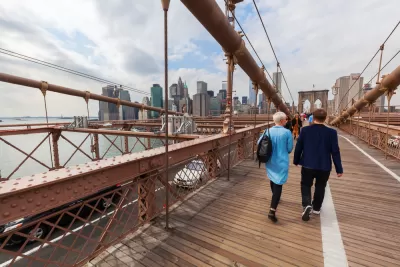
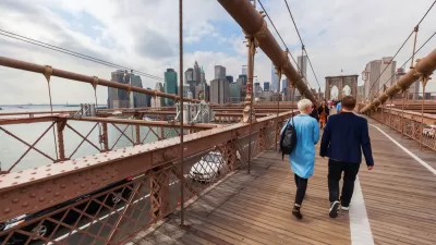
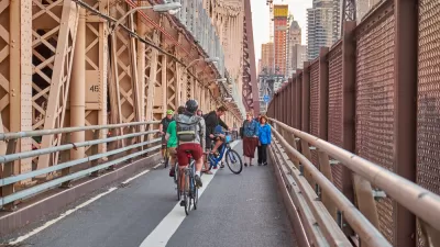
Unlike the High Bridge and the High Line, though, the Brooklyn Bridge serves as a critical commute corridor between two of New York's most populous boroughs, and the limited promenade, 10-feet wide at its narrowest point according to Transportation Commissioner Polly Trottenberg in this August 2016 New York Times video, has created friction between the three users: cyclists, pedestrians, and vendors.
Furthermore, the iconic bridge also doubles as the top tourist attraction in Brooklyn, and ranks fifth in New York City, according to an engineering report released this month, "Brooklyn Bridge Promenade — Recommendation Report" [pdf] for the New York City Department of Transportation, and that has created serious promenade congestion. The report was commissioned in August 2016 in part to see if the promenade could be widened
"From 2008 to 2015 pedestrian volumes increased 275% on weekends and cyclists increased 104%," according to the report by the consulting firm, AECOM.
"In response, the New York City Department of Transportation is taking a series of steps to relieve congestion on the Brooklyn Bridge, including possibly creating a separate bike-only entrance to the bridge on the Manhattan side and limiting the number of vendors and where they can sell on the promenade," reports Winnie Hu for The New York Times on Dec. 8.
The report does not recommend widening the promenade for the same reason many transportation advocates oppose widening freeways – it creates induced demand, "add[ing] more weight to the bridge, which could be a problem," writes Hu.
Aecom recommended an inspection of the bridge’s cables before considering any deck expansion, according to the report. The cables, which are original [including the inferior ones installed by the shady contractor, J. Lloyd Haigh,] had already been scheduled for a full inspection in 2019, the first since the 1980s.
The report did make some near-term recommendations, including a separate bike access [pdf] from Manhattan which "would divert cyclists from the heavily crowded entrance to the bridge...The city would create this bike entrance by converting a vehicle exit ramp on Park Row that was closed after the Sept. 11 terror attacks..."
The report also ruled out a more controversial approach that would turn an existing vehicle lane into a roadway bike lane — something that has been called for by cyclists, transportation advocates and urban planners. The report said that it raised safety concerns, would be difficult to maintain, and would lead to traffic backups.
That recommendation didn't sit well with Paul Steely White, the executive director of Transportation Alternatives, an advocacy group.
“Improving the entrances is welcome, but you’re not doing enough to address the core problem that there is not enough space for pedestrians and bikers on the bridge itself,” he said. “Generally, cars are still coming first and bikers and pedestrians are left to fight over the leftovers.”
In 1950, trolley tracks on the bridge were removed and traffic was restricted to passenger vehicles, notes the history section (page 5) of AECOM's 19-page powerpoint presentation [pdf].
The photos by Edu Bayer that accompany the article allow the reader to visualize the many problems that occur between the three users of the bridge, but it's the friction between pedestrian and cyclists that can be unsettling.
“I’m always looking on the side because I never know when I’m going to get hit by a bike," stated one pedestrian in Hu's earlier article (posted here) on promenade congestion.
FULL STORY: Want Fewer Crowds on the Brooklyn Bridge? You’re Not Alone

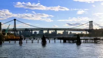
Single-Occupant Vehicles Banned on Williamsburg Bridge During L Train Closure
Solo commuters crossing from Brooklyn to Manhattan on the Williamsburg Bridge are in for a rude awakening on April 27 when the L Train closes. To accommodate more buses and bikes on the 115-year old bridge, cars will need at least 3 people.
First New Bridge to Manhattan in Decades Proposed Just for Pedestrians and People on Bikes
Introducing the proposed Queens Ribbon Bridge, a $100 million idea to connect Manhattan to Long Island City in Queens, by way of Roosevelt Island.
Bike-Centered Brooklyn Bridge Redo Under Consideration
City officials in New York are discussing the possibility of converting a car traffic lane on the Brooklyn Bridge for use by people on bikes.

Study: Maui’s Plan to Convert Vacation Rentals to Long-Term Housing Could Cause Nearly $1 Billion Economic Loss
The plan would reduce visitor accommodation by 25,% resulting in 1,900 jobs lost.

Alabama: Trump Terminates Settlements for Black Communities Harmed By Raw Sewage
Trump deemed the landmark civil rights agreement “illegal DEI and environmental justice policy.”

Why Should We Subsidize Public Transportation?
Many public transit agencies face financial stress due to rising costs, declining fare revenue, and declining subsidies. Transit advocates must provide a strong business case for increasing public transit funding.

Paris Bike Boom Leads to Steep Drop in Air Pollution
The French city’s air quality has improved dramatically in the past 20 years, coinciding with a growth in cycling.

Why Housing Costs More to Build in California Than in Texas
Hard costs like labor and materials combined with ‘soft’ costs such as permitting make building in the San Francisco Bay Area almost three times as costly as in Texas cities.

San Diego County Sees a Rise in Urban Coyotes
San Diego County experiences a rise in urban coyotes, as sightings become prevalent throughout its urban neighbourhoods and surrounding areas.
Urban Design for Planners 1: Software Tools
This six-course series explores essential urban design concepts using open source software and equips planners with the tools they need to participate fully in the urban design process.
Planning for Universal Design
Learn the tools for implementing Universal Design in planning regulations.
Smith Gee Studio
Alamo Area Metropolitan Planning Organization
City of Santa Clarita
Institute for Housing and Urban Development Studies (IHS)
City of Grandview
Harvard GSD Executive Education
Toledo-Lucas County Plan Commissions
Salt Lake City
NYU Wagner Graduate School of Public Service