


Disease mapping made a significant leap forward in the 19th century, and data scientists and geographic information scientists are still contributing to the public health field.
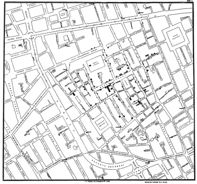
A post on the Sidewalk Labs blog explains an 1854 disease map that "changed the way cities studied public health."
"While many other innovations help keep city residents safe—sewers, fire safety, and vaccines all have more immediately observable effects—the disease map stands out for its ability to change the way we think about population health," according to the post.
Earlier attempts at mapping disease outbreaks failed due to bad assumptions and faulty science, but in 1854 John Snow mapped a London cholera outbreak and totally changed the public health profession's approach to epidemiology—and contributed to a new era of urban growth and industry. (It's no surprise, then, that Snow is often credited as the "father of epidemiology".)
Sidewalk Labs shares Snow's cholera map as the latest installment in the "15 Innovations That Shaped the City" series. According to the post, practices related to data collection and mapping continue to improve, and urban populations can expect even more improvements in public health.
FULL STORY: Disease Mapping: New Technology Meets an Ancient Discipline


Herd Immunity Finds Receptive Audience in White House and Florida
A trio of epidemiologists from Stanford, Harvard, and the University of Oxford have joined the president's new coronavirus medical advisor, Scott Atlas, in promoting an alternative approach to dealing with coronavirus infections.

Study: London ULEZ Rapidly Cleaning up Air Pollution
Expanding the city’s ultra low-emission zone has resulted in dramatic drops in particle emissions in inner and outer London.

London Low-Emissions Zone Prompts Shift to Active Modes
More children are using active transportation modes to get to school in the wake of a policy that charges drivers to enter a low-emissions zone in central London.

Study: Maui’s Plan to Convert Vacation Rentals to Long-Term Housing Could Cause Nearly $1 Billion Economic Loss
The plan would reduce visitor accommodation by 25,% resulting in 1,900 jobs lost.

North Texas Transit Leaders Tout Benefits of TOD for Growing Region
At a summit focused on transit-oriented development, policymakers discussed how North Texas’ expanded light rail system can serve as a tool for economic growth.

Using Old Oil and Gas Wells for Green Energy Storage
Penn State researchers have found that repurposing abandoned oil and gas wells for geothermal-assisted compressed-air energy storage can boost efficiency, reduce environmental risks, and support clean energy and job transitions.

Private Donations Propel Early Restoration of Palisades Playground
Los Angeles has secured over $1.3 million in private funding to restore the Pacific Palisades playground months ahead of schedule, creating a modern, accessible space that supports community healing after recent wildfires.

From Blight to Benefit: Early Results From California’s Equitable Cleanup Program
The Equitable Community Revitalization Grant (ECRG) program is reshaping brownfield redevelopment by prioritizing projects in low-income and environmental justice communities, emphasizing equity, transparency, and community benefits.

Planting Relief: Tackling Las Vegas Heat One Tree at a Time
Nevada Plants, a Las Vegas-based nonprofit, is combating the city’s extreme urban heat by giving away trees to residents in underserved neighborhoods, promoting shade, sustainability, and community health.
Urban Design for Planners 1: Software Tools
This six-course series explores essential urban design concepts using open source software and equips planners with the tools they need to participate fully in the urban design process.
Planning for Universal Design
Learn the tools for implementing Universal Design in planning regulations.
Ascent Environmental
Borough of Carlisle
Institute for Housing and Urban Development Studies (IHS)
City of Grandview
Harvard GSD Executive Education
Toledo-Lucas County Plan Commissions
Salt Lake City
NYU Wagner Graduate School of Public Service