


It's not impossible to reshape the suburbs to be more walkable, but it does require careful planning and design.
Can suburbs be walkable? Absolutely! Do we know how to create complete streets that are designed to be safe and inviting for people, bikes, and cars? Yes. Is it harder to promote walkability in suburbs than in cities? Not necessarily, but it requires careful thinking about how we shape the next era of suburban development.
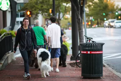
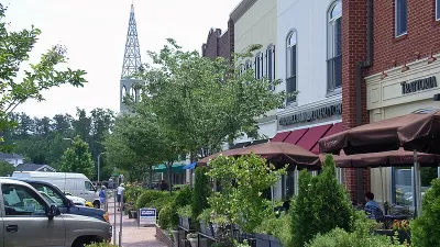
We know the basics. Walkable streets are typically tree-lined and well lit at a pedestrian scale. Walkable streets rarely require pedestrians to cross more than two lanes of traffic at a time. They have sidewalks wide enough for people to pass each other comfortably, for trees, and, ideally, for tables outside a café.
Walkable streets are lined with curbside parking (at least until autonomous mobility renders parking obsolete) and include bike lanes. They allow pedestrians and cyclists to stop and engage a friend, drop into a bakery or bookstore, or hang out in a square. They function as "third places," where people meet, gather, and celebrate in a diverse community.
Still, too many lifeless "Main Streets" check all the boxes without offering real walkability. Creating a great street designed for walking doesn’t necessarily mean people will use it for walking. The arrival of near-universal auto ownership following World War II forced walking into a competition for our time and our hearts. In the 21st century, this competition has grown more complex, with new competitors unleashed by the internet, mobile devices, and corporations fighting relentlessly for our time, attention, and disposable income.
Safety—actual and perceived—plays a key role in making suburbs walkable. Although roughly 30 cities have adopted safety-driven Vision Zero programs, only one suburban jurisdiction had done so as of January: Montgomery County, Maryland.
Walkable Main Streets don’t just accommodate walking; their programming and design actively invite it by following four principles.
- Promote density. Density is a threshold requirement that the subsequent principles can reinforce but not replace. Many suburbs have increased density allowances as a way to satisfy housing demand while bringing long-held community visions to life.Depending on household incomes, 1,000 to 2,000 housing units within a quarter-mile/five-minute walk can support a block of community-oriented Main Street retail—as opposed to chain stores that must draw from an area so large that customers have to drive. If the market can’t fully animate a Main Street with stores, cafés, and restaurants, then artist workspaces, dance studios, cultural amenities, entertainment, and similar active uses can help. Walk-to markets will gain importance as e-retailing continues chipping away at mass market, drive-to retail.As a rule of thumb, two or more square feet of office, research, and hotel space provide the same amount of support for retail as one square foot of housing.
- Connect to the larger community. Bike access continues to gain importance, in part because of its unmatched capacity to move people. Public transit [pdf] plays an even bigger role, boosting both the economic and social quality of residents' lives. Where possible, develop transit-oriented, walkable urban places, ideally within a five-minute walk of a station. A compact, walkable urban place may also provide sufficient ridership to justify extension of a nearby light rail or bus rapid transit line.
- Use parking strategically. A single garage can serve workers during the weekday; residents at night and on weekends; and restaurants, shops, and other uses throughout the week. A garage that requires walking brings life to the blocks around it (but should never sit on a Main Street— nothing kills walkability like hulking blank walls). The walk to or from the garage can showcase everything a neighborhood offers. For example, a new mixed-use "urban village" in the Boston suburb of Newton locates much of its parking in a central garage, wrapped with housing and retail. On their way to or from their cars, people pass shops, restaurants, craft breweries, and cafés.
- Invite walkability in every season. Walkable streets should celebrate regional ecology with native plants and other natural features that underscore the pleasure of being outdoors. Weather and climate can, however, strip away the charm. Enclosed malls solved this problem but their artificial environment lost appeal over time. "Managing" weather today means creating a great place to be outside any day of the year.
- Cold climates: walkable streets in "winter cities" can’t afford to take six months off, and many have devised ways to attract people throughout the year. Proclaiming "climate is our ally," Edmonton treats winter as an opportunity to reconnect with childhood fun and whimsy. Warming huts and pop-up patios appear in parks, where people gather around fires with hot drinks and music. Instead of hauling away cleared snow, the city uses it to fill parks with sledding hills, labyrinths, and walls that kids of all ages paint. Darkness arrives early, so Edmonton uses fire and outdoor lighting to help make even the drabbest block feel enchanted.
- Hot, humid climates: "summer cities" face equal challenges. The narrow passageways and fountains that characterize the historic medinas of North Africa represent centuries-old ways of creating shade and enlisting the cooling effect of water. While misting represents one newer cooling technique, it consumes significant energy; fountains, water courses, and other features that animate as well as cool offer a more sustainable approach and add appealing elements to the public realm. Cities like Miami and Austin have worked to increase tree canopy along streets to cool pedestrians in the hottest months of the year.
The same recipe that creates walkability downtown—density, connectivity, strategic use of parking, and the creative embrace of climate—doesn’t have tostaydowntown. Applied with care, it can bring walkability to the growing group of suburbs that see their future in the creation or extension of walkable urban centers.
Jason Beske AICP, a planner based in Northern Virginia, has played a key role in shaping walkable suburban environments in metro Washington, D.C. David Dixon FAIA, head of planning and urban design for Stantec’s Urban Places, has led planning for significant urban districts in cities and suburbs across North America. They are the co-editors of Suburban Remix: Creating the Next Generation of Urban Places (Island Press, 2018).

Rethinking Suburban Development: New Trends in Creating Livable Communities
Discover new trends in suburban development focused on creating more livable, sustainable communities for future growth.
A ‘New Urbanism’ Travelogue
I visited three New Urbanist developments in North Carolina. Here's what I liked, what I didn't like, and what I learned.

North Texas Transit Leaders Tout Benefits of TOD for Growing Region
At a summit focused on transit-oriented development, policymakers discussed how North Texas’ expanded light rail system can serve as a tool for economic growth.

Alabama: Trump Terminates Settlements for Black Communities Harmed By Raw Sewage
Trump deemed the landmark civil rights agreement “illegal DEI and environmental justice policy.”

Planetizen Federal Action Tracker
A weekly monitor of how Trump’s orders and actions are impacting planners and planning in America.

How Atlanta Built 7,000 Housing Units in 3 Years
The city’s comprehensive, neighborhood-focused housing strategy focuses on identifying properties and land that can be repurposed for housing and encouraging development in underserved neighborhoods.

In Both Crashes and Crime, Public Transportation is Far Safer than Driving
Contrary to popular assumptions, public transportation has far lower crash and crime rates than automobile travel. For safer communities, improve and encourage transit travel.

Report: Zoning Reforms Should Complement Nashville’s Ambitious Transit Plan
Without reform, restrictive zoning codes will limit the impact of the city’s planned transit expansion and could exclude some of the residents who depend on transit the most.

Judge Orders Release of Frozen IRA, IIJA Funding
The decision is a victory for environmental groups who charged that freezing funds for critical infrastructure and disaster response programs caused “real and irreparable harm” to communities.
Urban Design for Planners 1: Software Tools
This six-course series explores essential urban design concepts using open source software and equips planners with the tools they need to participate fully in the urban design process.
Planning for Universal Design
Learn the tools for implementing Universal Design in planning regulations.
Jessamine County Fiscal Court
Caltrans
Institute for Housing and Urban Development Studies (IHS)
City of Grandview
Harvard GSD Executive Education
Toledo-Lucas County Plan Commissions
Salt Lake City
NYU Wagner Graduate School of Public Service