


City Profiles
Explore cities through an urban planning lens.
Philadelphia: An Urban Planner's Guide to the City
One of the nation’s oldest cities, Philadelphia boasts a rich history and a walkable, compact central grid built around public plazas.

Basics
- State: Pennsylvania
- Incorporation date: October 25, 1701
- Area: 46,055 square miles
- Statehood: December 12, 1787
- Population*: 1,603,797
- Type of government: Mayor–council with consolidated city-county
- Planning department website: Department of Planning and Development
- Comprehensive plan: Philadelphia 2035
*Current as of 2020 Census.
Philadelphia's indigenous history
Prior to European colonization, the area now known as Philadelphia was inhabited by the Lenape, or Delaware, people. One of the region’s largest settlements was located in what is now South Philadelphia and was known as Passyunk. Other tribes in the Pennsylvania area included the Susquehannock, Shawnee, and Iroquois. The Lenape subsisted primarily on hunting, fishing, and agricultural cultivation around the Delaware and Schuylkill Rivers.
The first Europeans to acquire land from the Lenape were Dutch and Swedish colonists in 1638. In 1682, King Charles II allocated much of the land to William Penn as a colony for persecuted Quakers. Penn and the Lenape signed the Shackamaxon agreement, which let the tribe retain certain villages and lands. After Penn’s death, his son used a disingenuous new agreement, the Walking Purchase of 1737, to force the Lenape to sell nearly one million acres of land. Tensions grew between Native Americans and the Quakers, leading to a massacre of Conestoga people by a mob in 1763.
Native communities were ultimately scattered by disease and dispossession. As of the 2010 Census, 13,000 Philadelphia residents identified as Native American.
Colonization, trade, and the American Revolution
The region was first explored by Henry Hudson during his Northwest Passage expedition. The first permanent European settlement in the Delaware Valley was Fort Christina, founded in March 1638 by Dutch colonists looking to trade furs and tobacco. Swedish immigrants also staked a claim.
The first English arrived in 1642, sparking conflict with the Dutch and Swedish settlers. In 1664, the English captured New Netherland. After William Penn’s arrival in 1682, the English population grew to a few hundred as the Quakers settled into a comparatively cooperative relationship with the Lenape.
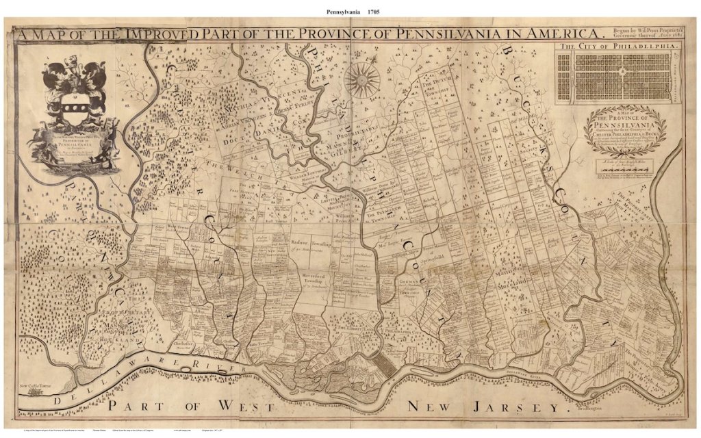
William Penn established Philadelphia as a city with the Charter of 1701, which created the city’s structure and gave its officials the authority to make laws and regulations. Thanks to its location near two rivers, Philadelphia became an important port and trading center.
Known for its religious tolerance thanks to its Quaker roots, the city attracted people of various religions and nationalities, but this also created conflict. Like other colonial cities, Philadelphia experienced growing pains as it dealt with a growing population, inadequate infrastructure, and political corruption.
Philadelphia played a major role in the American Revolution, serving as the meeting place of the First Continental Congress in 1774 and the Second Continental Congress the following year. In July 1776, the Congress met to sign the Declaration of Independence. The city was called “the heart” of the war due to its strategic position, large number of arms manufacturers, and other advantages. After the war, the city served as the temporary capital of the newly formed United States of America from 1790 to 1800.
New immigration and the ‘Great Migration’ of formerly enslaved Black Americans moving from Southern states swelled the city’s population in the mid-1800s, straining resources as neighborhoods grew. By the late 1800s, the city’s main industries were textiles, locomotive factories, shipbuilding, iron and steel manufacturers, and the Pennsylvania Railroad.
From its founding, William Penn insisted that Philadelphia build roads before selling lots for development. The first city plan, created in 1683, included a gridded street pattern, a central public square, various street widths, and open public plazas. The plan also accounted for future growth, including land for future development.
The Philadelphia plan was the first in the United States to design street widths appropriate to their adjacent uses. Major streets were 100 feet wide, riverfront streets were 60 feet wide, and other, smaller streets were 50 feet wide. The design of public squares into the city plan was another innovative idea, with Penn calling for them to remain open to free public recreation.
20th century growth: Immigration, suburbanization, and zoning
During World War I, Philadelphia became an important shipbuilding center. However, the city was devastated by the 1918-1919 flu pandemic, which spread quickly during the Liberty Loan parade of October 1918 and killed some 20,000 residents.
The Great Depression forced the closure of dozens of local banks and decimated the local manufacturing and construction industries. However, immigration continued to diversify the city throughout the mid-20th century, with the population peaking at more than two million residents in 1950. Thereafter, the decline of manufacturing and railroad jobs, white flight, and increased suburbanization drew residents away from the central city, which lost 13 percent of its population in the 1970s. The 1990s saw targeted efforts from city leaders to promote revitalization and boost the central city’s population, which had been in decline for four decades.
Zoning played an important and early role in Philadelphia’s development. The first zoning code, enacted in 1933, created a series of residential, commercial, and industrial classifications that was largely modeled on existing land uses. That code included 20 types of zoning districts including residential, commercial, shopping centers, and parks. The code created a Zoning Board of Adjustment to review zoning application appeals.
The first major overhaul of the zoning code happened in 1962, but changes in the city’s economy and demographics rendered these changes largely obsolete. Fewer multifamily buildings were constructed as industries declined and households fled to the suburbs. In 1988, a plan to overhaul zoning in Center City led to the redevelopment of downtown in the 1990s and 2000s.
As the zoning code grew and became more unwieldy and archaic (for example, one provision stated that one could build a factory to produce rigatoni and ravioli, but not angel hair pasta), roughly half of projects had to go through the ZBA for variances and approvals. In 2011, the city passed a revised zoning code aimed at simplifying regulations and encouraging density and less car-centric development. The new zoning code went into effect in August of 2012.
21st century concerns: Population decline, poverty, aging infrastructure
In 2024, the city has an unemployment rate of 4.2 percent, the lowest in three decades, but more than 1 out of 5 residents live below the poverty line. Immigrants continue to make up a significant segment of the population at 15.7 percent. The median income rose by 19 percent between 2019 and 2022 to $56,517, but remains below the national average ($74,580). Philadelphia also faces a serious opioid crisis and has the highest rate of unintentional drug overdose deaths among major U.S. cities.
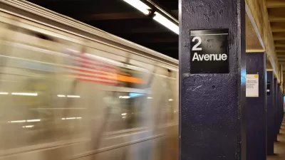
Like other transit agencies in the United States, the Southeastern Pennsylvania Transportation Authority (SEPTA), faces major budget deficits and ridership levels that have been slow to recover after the Covid-19 pandemic. The city’s school system faces similar financial hardships.
In many ways, Philadelphia's original city grid meshes well with New Urbanism concepts that support density and walkability. However, aging infrastructure and narrow streets can pose challenges to redevelopment and Complete Streets efforts.
Philadelphia's key planning milestones
- 1683: First city plan of Philadelphia is published in London to advertise the city to potential immigrants.
- 1854: The Act of Consolidation makes the boundaries of the city and county and Philadelphia coterminous.
- 1907: Philadelphia builds its first subway line. The Market–Frankford Line (MFL), now known as the L, is today the busiest route in the SEPTA system.
- 1933: Philadelphia enacts its first zoning code.
- 1962: The city overhauls its zoning code for the first time.
- 1963: The Southeastern Pennsylvania Transportation Authority (SEPTA) is formed.
- 2011: City Council approves zoning reforms that include reduced minimum parking requirements, smaller minimum lot sizes, and a new Civic Design Review process that applies to large developments and encourages public spaces and community amenities. The city also launches the Philadelphia 2035 Comprehensive Plan.

They Had No Heat for Months. A New Law Let Them Sue.
In New York state, tenants can now take landlords to court directly to force repairs and get damages, without withholding rent first. Here’s how one of the first tests of the new law worked.
New York Governor Announces 2024 Transportation Plans
Gov. Hochul’s plans include the long-awaited Second Avenue Subway extension.

Main Street Redevelopment Hopes To Lure NYC Commuters to Village of Brewster
Officials in the Village of Brewster, a community of just over 2,000 people in New York's Putnam County, hope a redesign of their downtown will attract new residents who want to escape the clamor of the city.

Urban Design for Planners 1: Software Tools
This six-course series explores essential urban design concepts using open source software and equips planners with the tools they need to participate fully in the urban design process.
Planning for Universal Design
Learn the tools for implementing Universal Design in planning regulations.
Caltrans
Smith Gee Studio

Institute for Housing and Urban Development Studies (IHS)
City of Grandview
Harvard GSD Executive Education
Toledo-Lucas County Plan Commissions
Salt Lake City
NYU Wagner Graduate School of Public Service