


Blogger Kayla Matthews examines the many challenges planners face in preparing for the extreme weather and flooding caused by climate change.


As city planners evaluate how to help buildings withstand current environmental conditions, they must also consider how climate-related conditions may worsen over the decades and pose risks that weren’t initially so severe.
One especially prominent concern for urban planners is flood preparation.
Climate Shift Is Already in Effect
Meteorological data indicate climate shift isn't something that'll start decades from now. It's already happening. Scientists say tidal flooding is twice as likely to reach high levels now compared to three decades ago.
Researchers also highlight climate shift as a contributor to higher-than-average snowfall totals and harder-hitting hurricanes.
Understanding Different Types of Flood Risks
In the same way architects and engineers design buildings or bridges tolerate specific weights, city planners design stormwater management systems to accommodate expected environmental behavior such as rainfall totals or riverbank overruns. When the amount of water becomes higher than what’s typical for an area, flooding happens.
In some places, such as Houston, TX, urban planners know flooding is a certainty. They design and build drainage channels, ditches, and detention ponds to either contain water or move it away from areas where people live. When those fill up, water goes onto the roadways.
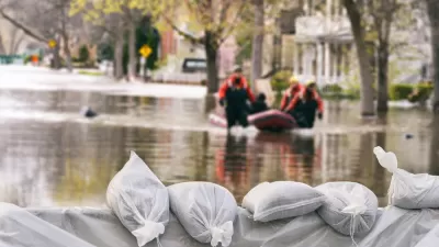
Analysts say Hurricane Harvey proved Houston still has work to do in figuring out how to manage intense flooding. The ideal situation is to create communities where people can stay safe when flooding happens, not discourage development from occurring in those places.
It’s also important for city planners to consider how flooding risks differ in specific areas. In Houston, flooding is most likely to happen due to rainfall. In Hobart, Australia, however, flooding tends to be the result of the lack of green spaces and earthy areas around the city, which traditionally would act a bit like sponges. With much of the city covered by houses, asphalt and buildings today, heavy rainwater has nowhere to go, and so flooding occurs. This makes Hobart’s flooding problems a city planning responsibility.
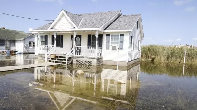
But, in New Orleans, the threat of flooding exists because the city is comparatively much closer to sea level. A decade after Hurricane Katrina, engineers in New Orleans have spent over $1 billion to improve flood control in the city.
Diesel-powered engines pump water out of the area, and investments in better construction materials and computerized storm models have improved floodgates. But, the officials involved in these projects caution that these measures reduce risk, not eliminate it.
Flooding Hinders Commercial Establishments
The restaurant sector, like numerous other industries, was hard-hit by Hurricane Harvey’s Texas floods during September of 2017. Facility owners reported throwing away immense amounts of ruined food and beverages, losing profits due to lengthy closures and spending hundreds of thousands of dollars to repair floors, damaged equipment and more.
In some cases, the problems were especially damaging because establishments had leaky roofs before the flooding. The owners of Reef, a restaurant in the Houston area serving Gulf Coast cuisine, reported noticing roof issues during previous hurricanes that only exacerbated during Hurricane Harvey. They hope to reopen for customers in November 2018.
City planners could help minimize such issues by working with building departments to track and recognize signs of trouble, such as damaged flashing or cracked membranes, and strengthen and enforce existing fire and safety codes.
Some Planners Choose to Develop in Floodplains—After Taking Precautions
Commercial establishments are often located in floodplains categorized by the likelihood of flooding. For example, an area designated as a 500-year floodplain has a 0.2 percent chance of flooding in any given year. After five centuries, the total risk of flooding reaches 100 percent.
Some business owners who operate in areas with a projected low risk of flooding don’t get flood insurance. But, that decision could shutters their establishments for good.
In contrast, Woodward, a manufacturing company intending to build its world headquarters in Fort Collins, CO on a floodplain that was formerly a golf course. It took strategic precautions to reduce risks of future flooding.
For example, people involved in the planning and execution processes elevated all the buildings above ground level and came up with a water management plan that allows the nearby Cache la Poudre River to flow naturally during flooding instead of disrupting the surrounding infrastructure. The latter tactic represents an approach called passive design, which requires incorporating nature’s characteristics into planning and understanding how they interact with human-built aspects of the environment.
Planning For Floods Requires Substantial Funding and Expert Assistance
After hearing the results of a flood risk assessment for Vancouver, Canada, city council officials there learned they needed to provide a total of $1 billion in investment over the next 82 years to handle an anticipated one-meter sea level rise caused by climate shift.
Analysts warned the resulting damage to buildings and land from future floods could be much costlier than that preventive expense. Vancouver already made proactive moves to reduce the risk of flooding, such as increasing the minimum flood construction levels for buildings. However, Vancouver has not yet made a long-term plan for dealing with floods.
Vancouver will take that all-important step with $1 million in funding—with half the amount coming from the local government and the rest from private foundations or upper levels of government—to hire national and international experts and task them with developing solutions for areas in the city most vulnerable to flooding.
Vancouver’s chief city planner expects to create up to eight teams of people with advanced knowledge about how to design and improve infrastructure over time and allocate them to specific areas of the city.
No Quick and All-Encompassing Solution
This overview of urban planning and flood preparation indicates the lack of a single solution that’s effective in every case.
Instead, skilled planners must assess the current infrastructure, known and potential risks and population concentrations while weighing the pros and cons of all possibilities.

A Different Approach to Managing Climate Displacement
As climate-driven flooding and storms put increasing pressure on coastal communities, some say the piecemeal nature of federal recovery and mitigation efforts aren’t cutting it.
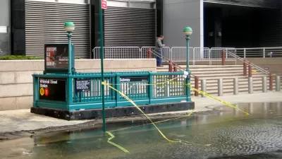
How Extreme Weather Threatens Transit Systems
As weather events become more intense and unpredictable, transit agencies must take steps to protect their aging infrastructure from flooding, storms, and extreme heat.
Infrastructure Must Catch Up With Climate Change
The worsening effects of extreme weather events are accelerating the deterioration of critical infrastructure, leaving communities more vulnerable.

Study: Maui’s Plan to Convert Vacation Rentals to Long-Term Housing Could Cause Nearly $1 Billion Economic Loss
The plan would reduce visitor accommodation by 25,% resulting in 1,900 jobs lost.

North Texas Transit Leaders Tout Benefits of TOD for Growing Region
At a summit focused on transit-oriented development, policymakers discussed how North Texas’ expanded light rail system can serve as a tool for economic growth.

Why Should We Subsidize Public Transportation?
Many public transit agencies face financial stress due to rising costs, declining fare revenue, and declining subsidies. Transit advocates must provide a strong business case for increasing public transit funding.

How to Make US Trains Faster
Changes to boarding platforms and a switch to electric trains could improve U.S. passenger rail service without the added cost of high-speed rail.

Columbia’s Revitalized ‘Loop’ Is a Hub for Local Entrepreneurs
A focus on small businesses is helping a commercial corridor in Columbia, Missouri thrive.

Invasive Insect Threatens Minnesota’s Ash Forests
The Emerald Ash Borer is a rapidly spreading invasive pest threatening Minnesota’s ash trees, and homeowners are encouraged to plant diverse replacement species, avoid moving ash firewood, and monitor for signs of infestation.
Urban Design for Planners 1: Software Tools
This six-course series explores essential urban design concepts using open source software and equips planners with the tools they need to participate fully in the urban design process.
Planning for Universal Design
Learn the tools for implementing Universal Design in planning regulations.
Ascent Environmental
Borough of Carlisle
Institute for Housing and Urban Development Studies (IHS)
City of Grandview
Harvard GSD Executive Education
Toledo-Lucas County Plan Commissions
Salt Lake City
NYU Wagner Graduate School of Public Service