


The U.S. Department of Transit has released its first ever National Transit Map.
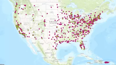
"The U.S. Department of Transportation’s Bureau of Transportation Statistics (BTS) today released National Transit Map data, a geospatial database containing the information submitted by almost 200 transit agencies that provides open, machine-readable data about their stops, routes, and schedules," according to a press release from BTS.
The national, openly available map of fixed-guideway and fixed-route transit service in America will allow the U.S. Department of Transportation (DOT) to demonstrate the importance and role of transit in American society and to identify and address gaps in access to public transportation. It will also support research, planning and analysis on the benefits of transit, such as the economic impacts of transit on a community’s economic development, or on reducing poverty in low-income neighborhoods.
Transportation Secretary Anthony Foxx also penned a blog post for the occasion, including a call for action to fill in some of the gaps in the map.
We have work still to do to ensure that each transit agency has this kind of data so we can make sure the Map represents all transit service. We're taking an iterative approach to building this important asset, and we are looking forward to demonstrating progress in future releases.
The idea for the National Transit Map was announced back in March, and between that time and now, the team behind the map gathered data from 270 transit agencies to map "nearky [sic] 400,000 stops and stations on nearly 10,000 routes."

FULL STORY: National Transit Map Data

U.S. DOT Making a National Transit Map
Transportation Secretary Antony Foxx called on local transit agencies earlier this month to share data to be used in building a comprehensive map of the nation's transit lines.
Transportation Secretary Foxx Wants to Go Out With a Bang
Governing profiles Transportation Secretary Anthony Foxx's ambitious goals to change the way the country thinks about transportation.
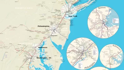
Financing of Hudson River Rail Tunnels in Peril
A funding agreement between New York, New Jersey, and the U.S. DOT for one of the most important rail projects in the nation is in danger of collapsing because of the way the two states are financing their share of the $12.9 billion cost.

Study: Maui’s Plan to Convert Vacation Rentals to Long-Term Housing Could Cause Nearly $1 Billion Economic Loss
The plan would reduce visitor accommodation by 25,% resulting in 1,900 jobs lost.

North Texas Transit Leaders Tout Benefits of TOD for Growing Region
At a summit focused on transit-oriented development, policymakers discussed how North Texas’ expanded light rail system can serve as a tool for economic growth.

Why Should We Subsidize Public Transportation?
Many public transit agencies face financial stress due to rising costs, declining fare revenue, and declining subsidies. Transit advocates must provide a strong business case for increasing public transit funding.

How to Make US Trains Faster
Changes to boarding platforms and a switch to electric trains could improve U.S. passenger rail service without the added cost of high-speed rail.

Columbia’s Revitalized ‘Loop’ Is a Hub for Local Entrepreneurs
A focus on small businesses is helping a commercial corridor in Columbia, Missouri thrive.

Invasive Insect Threatens Minnesota’s Ash Forests
The Emerald Ash Borer is a rapidly spreading invasive pest threatening Minnesota’s ash trees, and homeowners are encouraged to plant diverse replacement species, avoid moving ash firewood, and monitor for signs of infestation.
Urban Design for Planners 1: Software Tools
This six-course series explores essential urban design concepts using open source software and equips planners with the tools they need to participate fully in the urban design process.
Planning for Universal Design
Learn the tools for implementing Universal Design in planning regulations.
Ascent Environmental
Borough of Carlisle
Institute for Housing and Urban Development Studies (IHS)
City of Grandview
Harvard GSD Executive Education
Toledo-Lucas County Plan Commissions
Salt Lake City
NYU Wagner Graduate School of Public Service